Woodbury, Minnesota
| Woodbury, Minnesota | |||
|---|---|---|---|
| City | |||
| City of Woodbury | |||
|
Woodbury City Hall in October 2008 | |||
| |||
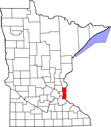
 Location of the city of Woodbury within Washington County, Minnesota | |||
| Coordinates: 44°55′08″N 92°56′12″W / 44.91889°N 92.93667°WCoordinates: 44°55′08″N 92°56′12″W / 44.91889°N 92.93667°W | |||
| Country | United States | ||
| State | Minnesota | ||
| County | Washington | ||
| Incorporated | 1967 | ||
| Government | |||
| • Mayor | Mary Giuliani Stephens | ||
| Area[1] | |||
| • City | 35.56 sq mi (92.10 km2) | ||
| • Land | 34.73 sq mi (89.95 km2) | ||
| • Water | 0.83 sq mi (2.15 km2) 2.33% | ||
| Elevation | 1,063 ft (302 m) | ||
| Population (2010)[2] | |||
| • City | 61,961 | ||
| • Estimate (2015)[3] | 67,855 | ||
| • Rank | US: 517th MN: 9th | ||
| • Density | 1,784.1/sq mi (688.8/km2) | ||
| • Metro | 3,524,583 (US: 16th) | ||
| ZIP codes | 55125, 55129 | ||
| Area code(s) | 651 | ||
| FIPS code | 27-71428 | ||
| GNIS feature ID | 0659734[4] | ||
| Website | www.ci.woodbury.mn.us | ||
.jpg)
Woodbury is a suburb of St. Paul and the largest city in Washington County, Minnesota. It is part of the greater Twin Cities metropolitan area. Woodbury is situated east of Saint Paul along Interstate 94. The population was 61,961 in 2010 but 2015 US Census estimates reveal a population of 67,855, making it Minnesota's ninth largest city.[5]
History


At almost 36 square miles in size, Woodbury is a direct descendant of one of the congressional townships that Minnesota Territory was divided into when the territory was ceded by the Native Americans of the United States and "opened to settlement." Woodbury was originally named Red Rock, but was renamed Woodbury after Levi Woodbury, the first justice of the Supreme Court of the United States to attend law school, realized that another Red Rock existed in Minnesota.[6] When first settled in 1844, the land was mostly wood but was converted to farmland. The township government was organized in 1858.[7] One of the city's few surviving 19th-century farms, the Charles Spangenberg Farmstead, is listed on the National Register of Historic Places.[8]
The first suburban housing development began in 1955, and the city has seen an increasing level of metropolitan expansion as the farmland has given way to developments and shopping malls.
Geography

According to the United States Census Bureau, the city has a total area of 35.56 square miles (92.10 km2), of which, 34.73 square miles (89.95 km2) is land and 0.83 square miles (2.15 km2) is water.[1]
The city is bounded on the northern side by Interstate 94, the south by 60th Street, the west by Century Avenue, and the east by Manning Avenue. The adjoining cities in these directions are, respectively, Oakdale, Landfall, Lake Elmo, Cottage Grove, Maplewood, Newport and Afton.
Woodbury is composed of upland between the valleys of the Mississippi River and St. Croix River. The northeast corner of Woodbury lies within the watershed of Valley Creek, one of the few remaining trout streams in the Twin Cities area. Valley Creek flows eastwards to the St. Croix River at Afton, Minnesota. The city also contains several small lakes, including Powers, Wilmes, Colby, Carver, and Battle Creek. Battle Creek lake is the source of Battle Creek, which flows westwards to the Mississippi River in Saint Paul.
Climate
| Climate data for Woodbury, Minnesota | |||||||||||||
|---|---|---|---|---|---|---|---|---|---|---|---|---|---|
| Month | Jan | Feb | Mar | Apr | May | Jun | Jul | Aug | Sep | Oct | Nov | Dec | Year |
| Average high °F (°C) | 23 (−5) |
30 (−1) |
42 (6) |
58 (14) |
71 (22) |
79 (26) |
83 (28) |
81 (27) |
72 (22) |
59 (15) |
41 (5) |
27 (−3) |
55.5 (13.1) |
| Average low °F (°C) | 6 (−14) |
13 (−11) |
24 (−4) |
36 (2) |
48 (9) |
58 (14) |
63 (17) |
61 (16) |
52 (11) |
40 (4) |
26 (−3) |
12 (−11) |
36.6 (2.6) |
| Average precipitation inches (mm) | 1.02 (25.9) |
0.78 (19.8) |
1.92 (48.8) |
2.54 (64.5) |
3.73 (94.7) |
4.98 (126.5) |
4.41 (112) |
4.37 (111) |
3.20 (81.3) |
2.51 (63.8) |
2.09 (53.1) |
1.04 (26.4) |
32.59 (827.8) |
| Source: http://www.weather.com/outlook/health/fitness/wxclimatology/monthly/graph/USMN0831 | |||||||||||||
Economy
State Farm Insurance was previously a large-scale employer in the city, but the multi-department facility was relocated to Lincoln, Nebraska while retaining a smaller work force at another site in Mendota Heights. There are also many smaller employers, such as the Joint Commission on Allied Health Personnel in Ophthalmology and offices for financial corporations. Many Woodbury residents are employed at 3M, whose headquarters are located a few miles west in Maplewood.
A large portion of the economy is retail. The two largest retail centers are Tamarack Village, near the intersection of Radio Drive and Interstate 94, and Woodbury Village, near the intersection of Valley Creek Road and Interstate 494. Woodbury Lakes, an upscale retail development with an open-air mall layout, was completed in 2005.
Largest employers
According to the City's 2015 Community Development Annual Report.[9]
| Rank | Employer | # of Employees |
|---|---|---|
| 1 | South Washington County Schools | 1,207 |
| 2 | Healtheast | 860 |
| 3 | Summit Orthopedics | 604 |
| 4 | Walmart | 333 |
| 5 | Assurant | 315 |
| 6 | Jerry's Enterprises | 305 |
| 7 | Target | 288 |
| 8 | Woodbury Senior Living | 261 |
| 9 | City of Woodbury | 251 |
| 10 | Allina | 250 |
| 11 | Globe University | 226 |
| 12 | Sam's Club | 218 |
| 13 | Health Partners | 216 |
| 14 | Cabela's | 188 |
| 15 | Northern Tier Energy | 180 |
Other important employers include eFunds, Long Term Care Group and Dean Foods/Land O'Lakes.
Education
Because most of Woodbury is located within the South Washington County School District, the majority of high school students attend either Woodbury High School or East Ridge High School. However, small portions of the city attend Tartan Senior High School in Oakdale and Stillwater Area High School in Stillwater. Some students attend public or private schools in other school districts chosen by their families under Minnesota's open enrollment statute.[10]

In November 2006, School District 833 selected an 80-acre (320,000 m2) site for a third high school, later named East Ridge High School. The site lies between two city-owned properties south of Bailey Road and east of Radio Drive: the 80-acre (320,000 m2) Bielenberg Sports Center and the Danner gravel pit. The city also owns an additional 80 acres (320,000 m2) south of the sports center to allow for expansion.[11] The new school opened in September 2009. The students attending this new High School came from Woodbury and nearby Cottage Grove as well as Newport and Saint Paul Park. Aaron Harper served as the school's principal. For more details on the new High School visit the school's website : http://www.sowashco.k12.mn.us/ERHS
There are two middle schools in Woodbury, Lake Middle School and Woodbury Middle School. Molly Roeske is the principal at Lake Middle School and their mascot is the "Leopards." Dennis Roos (2008) was the principal, now he is assistant principal at East Ridge High School in Woodbury. Kari Lopez (2009) is the principal and Kelli Isakson is the Assistant Principal at Woodbury Middle School and their mascot is the "Wildcats."
Woodbury is also home to the Minnesota Math and Science Academy, a charter school. Saint Ambrose of Woodbury is a Catholic school with Pre-K through 8th grade; and New Life Academy is a private Christian school and both are located within the city limits.
Globe University/Minnesota School of Business, a nationally accredited career college, provides hands-on training and offers master's, bachelor's and associate degree programs in business, information technology, health sciences and legal sciences at its Woodbury campus.
Rasmussen College–Lake Elmo / Woodbury campus serves students in the Woodbury area. Rasmussen College is a regionally accredited, career focused college that offeres bachelor and associate degree programs. Rasmussen College concentrates on programs in the following areas: health sciences, nursing, business, technology and design, criminal justice, and early education.
Recreation


Woodbury contains 45 parks covering approximately 3,000 acres (12 km2) and approximately 100 miles (160 km) of trails. The trails, most of which are paved, connect many of the parks. Three of the largest parks encircle Colby, Wilmes, and Powers lakes, respectively. The indoor Central Park is adjacent to the public library. Bielenberg Sports Center is the primary athletic location, including softball fields, baseball fields, soccer fields, football fields, sand volleyball courts, and an ice arena.
Two golf courses are located in the city: Prestwick (privately owned) and Eagle Valley (publicly owned). There are many local events year-round. A popular summer event named Woodbury Days is held in Ojibway Park each year. Woodbury Days includes a parade, carnival, live music, fireworks, and many booths for the city's shops, churches, and services. Woodbury Days is also known for its Taste of Woodbury tent located in the parking lot behind Woodbury High School and overlooking the Ojibway Park Band Shell. This tent includes many restaurants in the city. There's also a nice outdoor pool available by membership in the summer called Colby lake pool.
Athletics
The Minnesota Sting of the NEFL are a semi-pro football team in Woodbury.
Demographics

| Historical population | |||
|---|---|---|---|
| Census | Pop. | %± | |
| 1960 | 3,014 | — | |
| 1970 | 6,184 | 105.2% | |
| 1980 | 10,297 | 66.5% | |
| 1990 | 20,075 | 95.0% | |
| 2000 | 46,463 | 131.4% | |
| 2010 | 61,961 | 33.4% | |
| Est. 2015 | 67,855 | [12] | 9.5% |
| U.S. Decennial Census[13] 2015 Estimate[3] | |||
2010 census
As of the census[2] of 2010, there were 61,961 people, 22,594 households, and 16,688 families residing in the city. The population density was 1,784.1 inhabitants per square mile (688.8/km2). There were 23,568 housing units at an average density of 678.6 per square mile (262.0/km2). The racial makeup of the city was 81.4% White, 5.6% African American, 0.3% Native American, 9.1% Asian, 1.0% from other races, and 2.5% from two or more races. Hispanic or Latino of any race were 3.8% of the population.
There were 22,594 households of which 42.3% had children under the age of 18 living with them, 61.8% were married couples living together, 8.7% had a female householder with no husband present, 3.3% had a male householder with no wife present, and 26.1% were non-families. 20.4% of all households were made up of individuals and 5.7% had someone living alone who was 65 years of age or older. The average household size was 2.73 and the average family size was 3.20.
The median age in the city was 35.6 years. 29.6% of residents were under the age of 18; 6.2% were between the ages of 18 and 24; 29.6% were from 25 to 44; 26.3% were from 45 to 64; and 8.3% were 65 years of age or older. The gender makeup of the city was 48.2% male and 51.8% female.
2000 census
As of the census of 2000, there were 46,463 people, 16,676 households, and 12,657 families residing in the city. The population density was 1,327.7 people per square mile (512.6/km²). There were 17,541 housing units at an average density of 501.2 per square mile (193.5/km²). The racial makeup of the city was 90.04% White, 2.51% African American, 0.24% Native American, 5.01% Asian, 0.01% Pacific Islander, 0.62% from other races, and 1.56% from two or more races. Hispanic or Latino of any race were 2.14% of the population.
There were 16,676 households out of which 43.8% had children under the age of 18 living with them, 66.8% were married couples living together, 6.9% had a female householder with no husband present, and 24.1% were non-families. 18.8% of all households were made up of individuals and 3.3% had someone living alone who was 65 years of age or older. The average household size was 2.76 and the average family size was 3.20.
In the city the population was spread out with 30.6% under the age of 18, 5.9% from 18 to 24, 36.9% from 25 to 44, 20.5% from 45 to 64, and 6.1% who were 65 years of age or older. The median age was 33 years. For every 100 females there were 94.1 males. For every 100 females age 18 and over, there were 91.4 males.
The median income for a household in the city was $76,109, and the median income for a family was $84,997. Males had a median income of $60,224 versus $37,676 for females. The per capita income for the city was $32,606. About 0.8% of families and 1.7% of the population were below the poverty line, including 1.2% of those under age 18 and 1.2% of those age 65 or over.
References
- 1 2 "US Gazetteer files 2010". United States Census Bureau. Retrieved 2012-11-13.
- 1 2 "American FactFinder". United States Census Bureau. Retrieved 2012-11-13.
- 1 2 "Population Estimates". United States Census Bureau. Retrieved June 2, 2016.
- ↑ "US Board on Geographic Names". United States Geological Survey. 2007-10-25. Retrieved 2008-01-31.
- ↑ "2010 Census Redistricting Data (Public Law 94-171) Summary File". American FactFinder. U.S. Census Bureau, 2010 Census. Retrieved 23 April 2011.
- ↑ http://www.ci.woodbury.mn.us/house-home-and-pets-sp/new-resident-information/history-woodbury
- ↑ Upham, Warren (1920). Minnesota Geographic Names: Their Origin and Historic Significance. Minnesota Historical Society. p. 571.
- ↑ Dabrowski, Mario (1978-05-01). "National Register of Historic Places Inventory -- Nomination Form: Charles Spangenberg Farmstead" (PDF). National Park Service. Retrieved 2013-12-16.
- ↑ http://www.ci.woodbury.mn.us/images/community-development-annual-report-2015.pdf
- ↑ "Open Enrollment". Minnesota Department of Education. Archived from the original on 26 August 2010. Retrieved 19 November 2010.
- ↑ ISD 833 New High School/BSC - Process Update
- ↑ "Annual Estimates of the Resident Population for Incorporated Places: April 1, 2010 to July 1, 2015". Retrieved July 2, 2016.
- ↑ United States Census Bureau. "Census of Population and Housing". Retrieved July 14, 2014.
External links
| Wikivoyage has a travel guide for Woodbury. |
- City website
- Woodbury High School
- East Ridge High School
- South Washington County School District
- Woodbury Public Library (Washington County R.H. Stafford Library)
- Woodbury Athletic Association
- South Washington County Community Education
- Official Woodbury newspaper
- Woodbury Area Chamber of Commerce
Municipalities and communities of Washington County, Minnesota, United States | ||
|---|---|---|
| Cities |
|  |
| Townships | ||
| Unincorporated communities | ||
| Ghost towns | ||
| Footnotes | ‡This populated place also has portions in an adjacent county or counties | |