Faribault County, Minnesota
| Faribault County, Minnesota | |
|---|---|
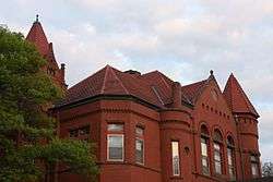 Faribault County Courthouse in Blue Earth | |
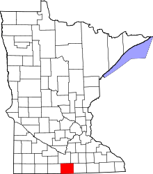 Location in the U.S. state of Minnesota | |
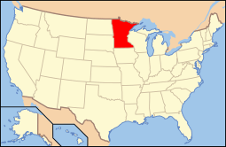 Minnesota's location in the U.S. | |
| Founded | February 20, 1855[1] |
| Named for | Jean Baptiste Faribault |
| Seat | Blue Earth |
| Largest city | Blue Earth |
| Area | |
| • Total | 722 sq mi (1,870 km2) |
| • Land | 712 sq mi (1,844 km2) |
| • Water | 9.4 sq mi (24 km2), 1.3% |
| Population (est.) | |
| • (2015) | 14,050 |
| • Density | 20/sq mi (8/km²) |
| Congressional district | 1st |
| Time zone | Central: UTC-6/-5 |
| Website |
www |
Faribault County /ˈfɛərᵻboʊ/ is a county located in the U.S. state of Minnesota. As of the 2010 census, the population was 14,553.[2] Its county seat is Blue Earth.[3] The county was founded in 1855.[4] It is named for Jean-Baptiste Faribault, a settler and French fur trader among the Sioux Indians.[5]
Geography
According to the U.S. Census Bureau, the county has a total area of 722 square miles (1,870 km2), of which 712 square miles (1,840 km2) is land and 9.4 square miles (24 km2) (1.3%) is water.[6]
Lakes
- Bass Lake: in Delavan Township
- Hart Lake: in Delavan Township
- Minnesota Lake: almost entirely in Minnesota Lake Township, but the extreme northern edge extends into Blue Earth County
- Rice Lake: in Delavan Township
- Rice Lake: there is another, smaller Rice Lake in Foster Township
- South Walnut Lake: almost entirely in Brush Creek Township, but the northern edge extends into Walnut Lake Township
- Walnut Lake: almost entirely in Walnut Lake Township, but the southern edge extends into Brush Creek Township
Major highways
 Interstate 90
.svg.png) U.S. Highway 169
U.S. Highway 169 Minnesota State Highway 22
 Minnesota State Highway 109
 Minnesota State Highway 253
 Minnesota State Highway 254
Adjacent counties
- Blue Earth County (north)
- Waseca County (northeast)
- Freeborn County (east)
- Winnebago County, Iowa (southeast)
- Kossuth County, Iowa (southwest)
- Martin County (west)
Demographics
| Historical population | |||
|---|---|---|---|
| Census | Pop. | %± | |
| 1860 | 1,335 | — | |
| 1870 | 9,940 | 644.6% | |
| 1880 | 13,016 | 30.9% | |
| 1890 | 16,708 | 28.4% | |
| 1900 | 22,055 | 32.0% | |
| 1910 | 19,949 | −9.5% | |
| 1920 | 20,998 | 5.3% | |
| 1930 | 21,642 | 3.1% | |
| 1940 | 23,941 | 10.6% | |
| 1950 | 23,879 | −0.3% | |
| 1960 | 23,685 | −0.8% | |
| 1970 | 20,896 | −11.8% | |
| 1980 | 19,714 | −5.7% | |
| 1990 | 16,937 | −14.1% | |
| 2000 | 16,181 | −4.5% | |
| 2010 | 14,553 | −10.1% | |
| Est. 2015 | 14,050 | [8] | −3.5% |
| U.S. Decennial Census[9] 1790-1960[10] 1900-1990[11] 1990-2000[12] 2010-2015[2] | |||

As of the census of 2000,[13] there were 16,181 people, 6,652 households, and 4,476 families residing in the county. The population density was 23 people per square mile (9/km²). There were 7,247 housing units at an average density of 10 per square mile (4/km²). The racial makeup of the county was 97.11% White, 0.24% Black or African American, 0.19% Native American, 0.36% Asian, 0.04% Pacific Islander, 1.36% from other races, and 0.69% from two or more races. 3.50% of the population were Hispanic or Latino of any race. 45.5% were of German, 21.2% Norwegian and 5.1% Irish ancestry.
There were 6,652 households out of which 28.50% had children under the age of 18 living with them, 57.80% were married couples living together, 6.10% had a female householder with no husband present, and 32.70% were non-families. 29.70% of all households were made up of individuals and 16.80% had someone living alone who was 65 years of age or older. The average household size was 2.36 and the average family size was 2.93.
In the county the population was spread out with 24.40% under the age of 18, 6.70% from 18 to 24, 23.20% from 25 to 44, 23.50% from 45 to 64, and 22.20% who were 65 years of age or older. The median age was 42 years. For every 100 females there were 97.20 males. For every 100 females age 18 and over, there were 92.50 males.
The median income for a household in the county was $34,440, and the median income for a family was $41,793. Males had a median income of $28,990 versus $20,224 for females. The per capita income for the county was $17,193. About 5.50% of families and 8.60% of the population were below the poverty line, including 9.40% of those under age 18 and 10.20% of those age 65 or over.
Communities
Cities
- Blue Earth (county seat)
- Bricelyn
- Delavan
- Easton
- Elmore
- Frost
- Kiester
- Minnesota Lake (partly in Blue Earth County)
- Walters
- Wells
- Winnebago
Townships
- Barber Township
- Blue Earth City Township
- Brush Creek Township
- Clark Township
- Delavan Township
- Dunbar Township
- Elmore Township
- Emerald Township
- Foster Township
- Jo Daviess Township
- Kiester Township
- Lura Township
- Minnesota Lake Township
- Pilot Grove Township
- Prescott Township
- Rome Township
- Seely Township
- Verona Township
- Walnut Lake Township
- Winnebago City Township
Unincorporated communities
See also
References
- ↑ "Minnesota Place Names". Minnesota Historical Society. Retrieved March 18, 2014.
- 1 2 "State & County QuickFacts". United States Census Bureau. Retrieved August 31, 2013.
- ↑ "Find a County". National Association of Counties. Retrieved 2011-06-07.
- ↑ Upham, Warren (1920). Minnesota Geographic Names: Their Origin and Historic Significance. Minnesota Historical Society. p. 183.
- ↑ Gannett, Henry (1905). The Origin of Certain Place Names in the United States. Govt. Print. Off. p. 123.
- ↑ "2010 Census Gazetteer Files". United States Census Bureau. August 22, 2012. Retrieved October 15, 2014.
- ↑ Nelson, Steven (2011). Savanna Soils of Minnesota. Minnesota: Self. pp. 65 - 67. ISBN 978-0-615-50320-2.
- ↑ "County Totals Dataset: Population, Population Change and Estimated Components of Population Change: April 1, 2010 to July 1, 2015". Retrieved July 2, 2016.
- ↑ "U.S. Decennial Census". United States Census Bureau. Retrieved October 15, 2014.
- ↑ "Historical Census Browser". University of Virginia Library. Retrieved October 15, 2014.
- ↑ "Population of Counties by Decennial Census: 1900 to 1990". United States Census Bureau. Retrieved October 15, 2014.
- ↑ "Census 2000 PHC-T-4. Ranking Tables for Counties: 1990 and 2000" (PDF). United States Census Bureau. Retrieved October 15, 2014.
- ↑ "American FactFinder". United States Census Bureau. Retrieved 2008-01-31.
External links
 |
Blue Earth County | Waseca County | | |
| Martin County | |
Freeborn County | ||
| ||||
| | ||||
| Kossuth County, Iowa | Winnebago County, Iowa |
Municipalities and communities of Faribault County, Minnesota, United States | ||
|---|---|---|
| Cities | | |
| Townships | ||
| Unincorporated communities | ||
| Ghost towns | ||
| Footnotes | ‡This populated place also has portions in an adjacent county or counties | |
Coordinates: 43°41′N 93°57′W / 43.68°N 93.95°W