Mitchell Highway
| Mitchell Highway Queensland–New South Wales | |
|---|---|
 | |
| A typical narrow width of the Mitchell Highway in the regional New South Wales village of Nevertire | |
 | |
| General information | |
| Type | Highway |
| Length | 1,105 km (687 mi) |
| Route number(s) |
(Nyngan - Bathurst) |
| Former route number |
|
| Major junctions | |
| North end | |
| South end | |
| Location(s) | |
| Major settlements | Charleville, Cunnamulla, Bourke, Nyngan, Narromine, Dubbo, Wellington, Orange |
| Highway system | |
|
Highways in Australia National Highway • Freeways in Australia Highways in Queensland Highways in New South Wales | |
| |
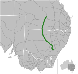
The Mitchell Highway is a state highway located in the central and south western regions of Queensland and the northern and central western regions of New South Wales in Australia. The Mitchell Highway forms part of the National Highway A32 corridor, which stretches from Sydney to Adelaide via Dubbo and Broken Hill. The Mitchell Highway also forms part of the shortest route between Sydney and Darwin, via Bourke and Mount Isa; making it an important road link for the transport of passengers and freight for regional New South Wales and Queensland.[1]
In New South Wales, the Mitchell Highway's south-eastern terminus is at its junction with the Great Western and Mid-Western highways, and it links with the Golden, Newell, Oxley, Barrier and Kamilaroi highways. In Queensland, the Mitchell links with the Balonne and Warrego highways and its northern terminates is at its junction with the Landsborough Highway.
Initially an amalgam of trunk routes, the 1,105-kilometre (687 mi)[2] Mitchell Highway was proclaimed a state highway in New South Wales in 1928 and named as the North Western Highway.[3] On 9 October 1936 the name was changed to the Mitchell Highway, in honour of Lieutenant Colonel Sir Thomas Mitchell, who was Surveyor-General of New South Wales in the 1820s and explored much of inland New South Wales, Victoria and Queensland.[4]
The Mitchell Highway carries the A32 shield from its eastern terminus in Bathurst to Nyngan;[5] thereafter carrying the B71 shield north to the New South Wales and Queensland border; the A71 shield to Charleville;[6] and then to its northern terminus with the Landsborough Highway at Augathella, the Mitchell concurrently carries the A71 and Alt A2 shields.[7]
Route
The Mitchell Highway lies west of the Great Dividing Range and in New South Wales runs generally northwest-southeast and in Queensland, runs generally north-south in the central western and southwest past of that state.
From its northern terminus at a junction with the Landsborough Highway near Augathella, the Mitchell Highway heads south, concurrently carrying both the A71 and Alt A2 shields and continues south through Charleville where the Warrego Highway heads east, carrying the Alt 2 shield. As the A71, the Mitchell continues south through Cunnamulla, forming a junction with the Balonne Highway, and then south to the state border between Queensland and New South Wales where its highway shield changes to B71.[2][6][7]
Approximately 5 kilometres (3.1 mi) north of Bourke it crosses the Darling River before heading into Bourke where it forms junctions with the Kamilaroi Highway heading east and the Kidman Way heading south. From this point the highway generally heads southeast through Nyngan where it forms a junction with the Barrier Highway. From this points until its southern terminus, the Mitchell carries the National Highway A32 shield. At Nevertire the Mitchell forms a junction with the Oxley Highway, before passing through Narromine and then heads generally east to the major rural centre of Dubbo where it meets with the Newell Highway and connects to the Golden Highway before crossing the Macquarie River and heading south towards Wellington, again crossing the Macquarie River. At Molong the Mitchell generally starts to head east towards Orange, where an alternative route diverts many heavy vehicles away from the city centre. The portion of the Mitchell Highway that passes through Orange city centre is known as Summer Street.[8] The Mitchell Highway's southeastern terminus is at a roundabout in Bathurst, at the junction of the Mid-Western Highway to Cowra and the Great Western Highway to Sydney via the Blue Mountains.[2][3][5]
Major intersections
| State | LGA | Location | km[2] | mi | Destinations | Notes |
|---|---|---|---|---|---|---|
| Queensland | Murweh | Augathella | 0 | 0.0 | Route northern terminus; Northern concurrency terminus | |
| Charleville | 78 | 48 | Southern concurrency terminus | |||
| Paroo | Cunnamulla | 278 | 173 | Bulloo Development Road (west) – Lake Bindegolly National Park | ||
| 282 | 175 | |||||
| New South Wales | New South Wales – Queensland state border | 397 | 247 | New South Wales – Queensland state border | Northbound transition as Southbound transition as | |
| Darling River | 528 | 328 | Gateway Bridge | |||
| Bourke | Bourke | 533 | 331 | |||
| 534 | 332 | |||||
| Bogan | Nyngan | 736 | 457 | North-westbound transition as South-eastbound transition as | ||
| Nevertire | 796 | 495 | Nevertire-Bogan Road (west) – Tottenham, Tullamore | |||
| Narromine | Narromine | 863 | 536 | Peak Hill Road (south) – Peak Hill, Parkes | Roundabout | |
| Dubbo | Dubbo | 901 | 560 | – connects at Dubbo to | Roundabout | |
| Macquarie River | 902 | 560 | L H Ford Bridge | |||
| Macquarie River | 951 | 591 | Bridge over the river (unknown name) at Wellington | |||
| Cabonne | Molong | 1,018 | 633 | |||
| Orange | Orange | 1,049 | 652 | Northern Distributor Road (northeast) | Alternative route to bypass Orange city centre; Roundabout | |
| 1,052 | 654 | Escort Way (west) – Eugowra, Forbes | ||||
| 1,057 | 657 | Northern Distributor Road (northwest) | Alternative route to bypass Orange city centre | |||
| Bathurst | Bathurst | 1,105 | 687 | Route south-eastern terminus; Roundabout | ||
1.000 mi = 1.609 km; 1.000 km = 0.621 mi
| ||||||
History
On 5 September 2014, a truck travelling on the Mitchell Highway rolled off a road bridge at Angellala Creek approximately 30km south of Charleville (26°39′15″S 146°10′34″E / 26.6541°S 146.1760°E). The truck was carrying 52 tonnes of ammonium nitrate which exploded. The blast destroyed the two road bridges and severely damaged the adjacent rail bridge.[9] The blast was so powerful that the truck was disintegrated and the dangers posed by the remaining ammonium nitrate necessitated a 2km exclusion zone around the site for a number of days.[10] The large crater formed by the blast closed the highway necessitating detours of up to 600km.[11] The Department of Transport and Mains Road was allowed to commence work at the site on 13 September and by 23 September had constructed a temporary side track around the blast site suitable for cars, buses and light trucks. By 7 October, the side track had been upgraded to support road trains, ending the need to detour.[12] In April 2015, the $10 million tender to reconstruct the highway and bridges were awarded and the construction work took place between June and November 2015.[13] In early 2016, a competition was held to decide a new name for the bridge.[12]
See also
References
- ↑ Sinclair Knight Merz Pty Ltd (June 2007). "Sydney–Dubbo Corridor Strategy: Building our National Transport Future" (PDF). Auslink. Australia: Department of Transport and Regional Services. ISBN 978-1-921095-46-7. Retrieved 4 April 2015.
- 1 2 3 4 Google (4 April 2015). "Driving directions Mitchell Highway" (Map). Google Maps. Google. Retrieved 4 April 2015.
- 1 2 "Mitchell Highway (NSW)". OzRoads: The Australian Roads website. Retrieved 14 August 2008.
- ↑ "Mitchell Highway: History and Development". OzRoads: The Australian Roads website. Retrieved 4 April 2015.
- 1 2 Rands, Paul (7 December 2013). "Great Western Highway, Mitchell Highway & Barrier Highway (A32)". Road Photos & Information: Queensland. Retrieved 4 April 2015.
- 1 2 Rands, Paul (2015). "Mitchell Highway (A71)". Road Photos & Information: Queensland. Retrieved 4 April 2015.
- 1 2 Rands, Paul (2015). "Warrego Highway & Mitchell Highway (Alternate A2)". Road Photos & Information: New South Wales. Retrieved 4 April 2015.
- ↑ "Summer Street Commercial Area" (PDF). Orange City Council. Archived from the original (PDF) on 22 July 2008. Retrieved 14 August 2008.
- ↑ "Queensland Disaster Committee Management 2014-15 Management Report" (PDF). Queensland Government. p. 7. Retrieved 5 September 2016.
- ↑ "Truck hauling fertiliser explodes in outback Queensland, injuring 8". Australian Broadcasting Corporation. 7 September 2014. Retrieved 5 September 2016.
- ↑ Calligeros, Marissa (23 September 2016). "Dirt road opens to Charleville after Mitchell Highway truck explosion". Brisbane Times. Retrieved 5 September 2016.
- 1 2 "Angellala Bridge reconstruction works". Department of Transport and Main Roads. Queensland Government. Retrieved 5 September 2016.
- ↑ Howells, Melinda (22 April 2016). "Angellala Creek bridge, destroyed in outback Queensland truck explosion, to be ready by November". Australian Broadcasting Corporation. Retrieved 5 September 2016.