Murray Valley Highway
| Murray Valley Highway New South Wales–Victoria | |
|---|---|
 | |
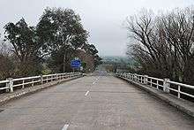
| Murray Valley Highway at Nathalia | |
 | |
| General information | |
| Type | Highway |
| Length | 663 km (412 mi)[1] |
| Route number(s) |
|
| Former route number |
|
| Major junctions | |
| NW end | |
|
| |
| SE end |
|
| Location(s) | |
| Major settlements | Robinvale, Swan Hill, Kerang, Echuca, Yarrawonga, Wodonga, Tallangatta[2] |
| Highway system | |
|
Highways in Australia National Highway • Freeways in Australia Highways in New South Wales Highways in Victoria | |
| |
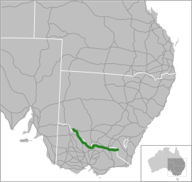
The Murray Valley Highway is a 663-kilometre (412 mi)[1] state highway located in Victoria and New South Wales, Australia.[3][4] For the vast majority of the course of the highway's length, the route is designated as B400.
Route
The Murray Valley Road was built in the late 1920s and early 1930s by the Country Roads Board of Victoria as part of a program of rural roads to facilitate development of the more remote parts of the state and provide connections between communities in addition to the roads and railways radiating out from Melbourne. It is one of a number of roads designated as a State Highway in 1933.[5] At that time, the highway ran from Corryong to the South Australian border. The western end of this route is now part of the Sturt Highway.
The popular tourist route follows the south side of the Murray River and effectively acts as the northern-most highway in Victoria. The western end of route B400 is the Murray River bridge at Robinvale, although the Murray Valley Highway crosses that bridge without the B400 designation (formerly as National Route 16[6]) to connect with the Sturt Highway 2 kilometres (1.2 mi) further north. Historically, the Murray Valley Highway continued west to connect with the Calder Highway at Hattah instead of crossing the river. The eastern end is in the foothills of the Great Dividing Range at Corryong. The alignment of the eastern end changed in the 1980s; whereby the highway used to go through Thologolong, Walwa and Towong (the current Murray River Road C546).[6]
The route also extends further east and crosses the border into New South Wales as the Alpine Way.
Most of the highway is fairly straight and flat, much of it through irrigated farmland. It becomes hillier and more winding east of Wodonga, with a moderately steep mountain pass near Koetong, between Tallangatta and Corryong.
The major towns along the route are Robinvale, Swan Hill, Kerang, Cohuna, Echuca, Nathalia, Strathmerton, Cobram, Yarrawonga, Rutherglen, Wodonga, Tallangatta and Corryong.
Major intersections and towns
| State | LGA | Location | km[1] | mi | Destinations | Notes |
|---|---|---|---|---|---|---|
| New South Wales | Balranald | Euston | 0 | 0.0 | T-intersection; western terminus; road continues southwest and northeast as the | |
| River Murray | 3 | 1.9 | Robinvale Bridge | |||
| New South Wales – Victoria state border | 4 | 2.5 | New South Wales – Victoria state border | |||
| Victoria | Swan Hill | Robinvale | 6 | 3.7 | ||
| Tol Tol | 25 | 16 | T-intersection | |||
| Piangil | 93 | 58 | ||||
| 95 | 59 | T-intersection | ||||
| Nyah | 110 | 68 | Speewah Road – Koraleigh | |||
| Swan Hill | 137 | 85 | Roundabout | |||
| Castle Donnington | 142 | 88 | ||||
| Gannawarra | Kerang | 194 | 121 | |||
| Loddon River | 195 | 121 | Patchell Bridge[7] | |||
| Gannawarra | Kerang | 196 | 122 | |||
| 199 | 124 | |||||
| Cohuna | 227 | 141 | ||||
| 228 | 142 | |||||
| Leitchville | 243 | 151 | ||||
| Campaspe | Echuca | 289 | 180 | |||
| 291 | 181 | Roundabout: western concurrency terminus with | ||||
| Campaspe River | 291.5 | 181.1 | Bridge over the river (bridge name unknown) | |||
| Campaspe | Echuca | 292 | 181 | Eastern concurrency terminus with | ||
| 293 | 182 | |||||
| Tongala | 312 | 194 | ||||
| Wyuna | 321 | 199 | ||||
| 325 | 202 | |||||
| Goulburn River | 329 | 204 | Bridge over the river (bridge name unknown) | |||
| Moira | Nathalia | 344 | 214 | |||
| 347 | 216 | |||||
| Broken Creek | 349 | 217 | Bridge over the river (bridge name unknown) | |||
| Moira | Strathmerton | 382 | 237 | Western concurrency terminus | ||
| Yarroweyah | 396 | 246 | Eastern concurrency terminus | |||
| Cobram | ||||||
| 400 | 250 | |||||
| 409 | 254 | |||||
| Yarrawonga Main Channel | 437 | 272 | Bridge over the channel (bridge name unknown) | |||
| Moira | Yarrawonga | 437 | 272 | |||
| 438 | 272 | Roundabout | ||||
| Esmond | 457 | 284 | ||||
| Ovens River | 459 | 285 | Parolas Bridge | |||
| Indigo | Rutherglen | 480 | 300 | |||
| 484 | 301 | Western concurrency terminus | ||||
| 485 | 301 | Roundabout; eastern concurrency terminus | ||||
| Browns Plains | 499 | 310 | ||||
| Barnawartha | 505 | 314 | ||||
| Barnawartha North | 511 | 318 | Trumpet interchange; grade separated; western concurrency terminus | |||
| Wodonga | Wodonga | 527 | 327 | Diamond interchange; grade separated; eastern concurrency terminus | ||
| Lincoln Causeway – Albury | ||||||
| 528 | 328 | |||||
| 531 | 330 | Bandiana Link Road (C410) – Wodonga, Albury | ||||
| Bandiana | 533 | 331 | ||||
| Kiewa River | 536 | 333 | Bridge over the river (bridge name unknown) | |||
| Wodonga | Bonegilla | 541 | 336 | |||
| Towong | Huon | 556 | 345 | |||
| Tallangatta | 574 | 357 | ||||
| Mitta Mitta River | 579 | 360 | Bridge over the river (bridge name unknown) | |||
| Towong | Bullio | 584 | 363 | |||
| Shelley | 611 | 380 | ||||
| Cudgewa | 633 | 393 | ||||
| Colac Colac | 643 | 400 | ||||
| Towong | 656 | 408 | ||||
| New South Wales – Victoria state border | 663 | 412 | New South Wales – Victoria state border | |||
| New South Wales | Murray River | Bringenbrong Bridge | ||||
| Snowy Valleys | Tooma | Alpine Way – Khancoban, Thredbo, Jindabyne | Western terminus; road continues into New South Wales as the Alpine Way | |||
1.000 mi = 1.609 km; 1.000 km = 0.621 mi
| ||||||
See also
| Wikimedia Commons has media related to Murray Valley Highway. |
References
- 1 2 3 "29 Murray Valley Highway, Euston NSW 2737, Australia to Murray Valley Highway, Towong Upper VIC 3707, Australia". Google Maps. 2016. Retrieved 15 November 2016.
- ↑ "Map of Murray Valley Highway". Bonzle Digital Atlas of Australia. 2016. Retrieved 16 November 2016.
- ↑ "Australian Towns, Cities & Highways: Murray Valley Highway". Hotkey. Retrieved 11 May 2008.
- ↑ "Murray Valley Highway". ExplorOz. Retrieved 11 May 2008.
- ↑ Twentieth Annual Report for year ended 30th June 1933 (PDF), Country Roads Board, p. 4
- 1 2 National Route 16 – Murray Valley Highway, Ozroads. Retrieved on 22 September 2013.
- ↑ O'Callaghan, Deborah (18 January 2011). "The Loddon River laps at Patchell Bridge, Kerang, in January 2011". ABC News. Australia. Retrieved 17 November 2016.