Oxley Highway
| Oxley Highway New South Wales | |
|---|---|
 | |
| General information | |
| Type | Highway |
| Length | 653 km (406 mi) |
| Route number(s) |
|
| Former route number |
|
| Major junctions | |
| West end | |
| East end |
|
| Location(s) | |
| Major settlements | Warren, Gilgandra, Coonabarabran, Gunnedah, Tamworth, Kootingal, Moonbi, Bendemeer, Walcha, Wauchope |
| Highway system | |
|
Highways in Australia National Highway • Freeways in Australia Highways in New South Wales | |
| |
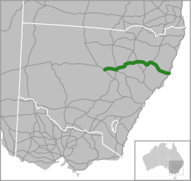
The Oxley Highway[1] is a rural highway in New South Wales, Australia. It starts at Nevertire where it joins the Mitchell Highway. It links Warren, Gilgandra, Coonabarabran, Gunnedah, Carroll, Tamworth, Bendemeer, Walcha, Yarrowitch, Ellenborough, Long Flat, Wauchope and ends at Port Macquarie on the coast of the Tasman Sea.
The Oxley Highway links with the Mitchell Highway at Warren before journeying to the Castlereagh Highway at Gilgandra, from where it is duplexed with the Newell Highway to Coonabarabran, thence to the New England Highway at Tamworth, with which it is duplexed to Bendemeer, the Thunderbolts Way at Walcha, and the Pacific Highway near Port Macquarie.
The highway was formerly signed National Route 34 for its entire length, however during 2013 the route west of Coonabarabran was decommissioned and east to Port Macquarie signed as the B56 as part of the new system of alpha-numeric route marking in NSW.
History
Work commenced in 1838 with the use of convicts working from Port Macquarie towards a spot known as "Prisoners’ Garden" about 20 km from Yarrowitch. Here it is said that the convicts were chained up each night. In 1842 the track from the Northern Tablelands to Port Macquarie was opened for the first time. Wool carried along this new route reduced the travelling time to 10 days, as opposed to 12–14 weeks for the trip to Maitland. The section from Walcha to Bendemeer existed as a mapped road in 1857, was surveyed in 1867, and proclaimed a Parish Road in c.1889. West of Walcha the road was only suitable for bullock teams and they too had difficulties, especially with the ranges.[2]
The steep range section from Yarras to Yarrowitch was in serious need of repair in 1925 when the Main Roads Board was formed. Following a re-survey in 1927 the road was altered between Yarras and Tobins Camp. The Highway was named in 1928 to commemorate John Oxley who was the first European to explore much of inland New South Wales in 1818. On 30 September 1933 the Highway section between Walcha and Port Macquarie was officially opened. Walcha Shire maintained 106 km of the Highway until July 1966 when this part was taken over by the Department of Main Roads.
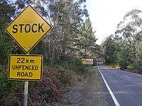
About 45 kilometres of the Yarrowitch to Wauchope section is unfenced and livestock (cattle) may be encountered there, along with other wild animals on most of the highway. Kangaroos are the most likely of those to be spotted, but wombats and other marsupials may be found.
Major intersections
| LGA | Location | km[3][4] | mi | Destinations | Notes | |
|---|---|---|---|---|---|---|
| Warren | Nevertire | 0 | 0.0 | Western end of Oxley Highway - continues south-west as Nevertire-Bogan Road towards Tottenham and Tullamore | ||
| Gilgandra | Gilgandra | 105.0 | 65.2 | Oxley Highway continues south to Newell Highway as Castlereagh Street | ||
| 105.1 | 65.3 | Newell Highway western concurrency terminus: continues south | ||||
| Castlereagh River | 105.1 | 65.3 | Jack Renshaw Bridge | |||
| Gilgandra | Gilgandra | 106.3 | 66.1 | |||
| Castlereagh River | 199.4 | 123.9 | Mary Jane Cain Bridge | |||
| Warrumbungle | Coonabarabran | 204.3 | 126.9 | Intersection is 5 km (3.1 mi) north-east of Coonabarabran Newell Highway eastern concurrency terminus: continues north | ||
| Gunnedah | Gunnedah | 305.6 | 189.9 | Kamilaroi Highway western concurrency terminus: continues north Oxley and Kamilaroi Highways continue south as Conadilly Street | ||
| 307.8 | 191.3 | Kamilaroi Highway eastern concurrency terminus: continues south | ||||
| Tamworth | Tamworth | 380.8 | 236.6 | New England Highway western concurrency terminus: continues south | ||
| Peel River | 381.1 | 236.8 | Bridge (no known official name) | |||
| Tamworth | Tamworth | 381.4 | 237.0 | Fossickers Way proceeds north from Tamworth via Peel Street and Manilla Road | ||
| Macdonald River | 421.1 | 261.7 | TA Perry Bridge | |||
| Tamworth | Bendemeer | 422.4 | 262.5 | New England Highway eastern concurrency terminus: continues north | ||
| Walcha | Walcha | 472.0 | 293.3 | Thunderbolts Way north - Uralla / south - Nowendoc and Gloucester | ||
| Apsley River | 472.1 | 293.3 | Bridge (no known official name) | |||
| Tia River | 507.5 | 315.3 | Bridge (no known official name) This bridge spans the boundary between the localities of Walcha and Yarrowitch | |||
| Yarrowitch River | 520.5 | 323.4 | Bridge (no known official name) | |||
| Ellenborough River | 601.6 | 373.8 | Bridge (no known official name) | |||
| Port Macquarie-Hastings | Sancrox – Thrumster boundary | 644.4 | 400.4 | Intersection is 9 km (5.6 mi) west of Port Macquarie, on the boundary between Sancrox and Thrumster, which follows the Pacific Highway | ||
| Port Macquarie | 653.0 | 405.8 | Hastings River Drive north - Pacific Highway / Ocean Drive south - Lake Cathie and Bonny Hills | Eastern end of Oxley Highway - continues east into Port Macquarie as Gordon Street | ||
1.000 mi = 1.609 km; 1.000 km = 0.621 mi
| ||||||
Gallery
 Signs, Oxley Highway.
 The Apsley Falls are located adjacent to the Oxley Highway, near Walcha.
See also
References
- ↑ Oxley Highway, Great Road Rides - New South Wales. Retrieved on 25 May 2008. Archived 19 July 2008 at the Wayback Machine.
- ↑ Donald, J.Kay, Exploring the North Coast and New England, Kangaroo Press, Kenthurst, 1978
- ↑ Google. "Sancrox, New South Wales" (Map). Google Maps. Google. Retrieved 15 October 2013.
- ↑ Google. "Thrumster, New South Wales" (Map). Google Maps. Google. Retrieved 15 October 2013.
- Walcha - 100 Years of Local Government, Walcha Shire Council, Newprint Industries, Walcha, 1989.
External links
![]() Oxley Highway travel guide from Wikivoyage
Oxley Highway travel guide from Wikivoyage