Gregory Highway
| Gregory Highway Gregory Developmental Road Queensland | |
|---|---|
 | |
| Gregory Highway (yellow on black), Gregory Developmental Road (green on black) | |
| General information | |
| Type | Highway |
| Length | 930 km (578 mi) |
| Route number(s) |
|
| Former route number |
(Charters Towers - Springsure) |
| Major junctions | |
| North end |
|
|
| |
| South end |
|
| Location(s) | |
| Major settlements | Charters Towers, Belyando Crossing, Clermont, Emerald |
| Highway system | |
|
Highways in Australia National Highway • Freeways in Australia Highways in Queensland | |
| |
The Gregory Highway is a state highway in Queensland that serves the major coal-mining centres of Central Queensland.[1] The highway was named after Augustus Gregory, an early explorer.
It runs southward from Quartz Blow Creek, a point 31 kilometres west of Mount Surprise on the Gulf Developmental Road, via Charters Towers, to Springsure, over 900 kilometres away.[2] The northern section of 756 kilometres is designated by the state government as the Gregory Developmental Road. The shorter southern section between Clermont and Springsure (174 kilometres) is designated the Gregory Highway. As of 2015, the first 120 kilometres between the Gulf Developmental Road via Einasleigh to the Lynd Junction are unsealed and may be corrugated. The next section to Charters Towers has been upgraded from single lane to mostly dual-laned bitumen.[2] The road is used by many road trains.
 High quality road section
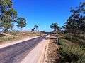 Example of poorer quality road section
List of towns along the Gregory Developmental Road/Highway
- Einasleigh
- Charters Towers
- Belyando Crossing
- Clermont
- Capella
- Emerald
- Springsure
Major intersections
| LGA | Location | km | mi | Destinations | Notes |
|---|---|---|---|---|---|
| Etheridge | Mount Surprise | 0 | 0.0 | east - Mount Surprise | Northern end of Gregory Developmental Road (No route number) |
| Conjuboy | 120 | 75 | east - Greenvale | Western concurrency terminus with Kennedy Developmental Road | |
| 123 | 76 | Eastern concurrency terminus with Kennedy Developmental Road | |||
| 123 | 76 | Gregory Developmental Road continues south-east as State Route 63 | |||
| Charters Towers | Basalt | 284 | 176 | ||
| Charters Towers | 382 | 237 | Northern concurrency terminus with Flinders Highway / Gregory Developmental Road continues south-west through Charters Towers | ||
| Black Jack | 390 | 240 | Southern concurrency terminus with Flinders Highway | ||
| 390 | 240 | Gregory Developmental Road continues south as State Route A7 | |||
| Isaac | Belyando | 588 | 365 | ||
| Clermont | 741 | 460 | Northern concurrency terminus with Peak Downs Highway | ||
| 755 | 469 | Southern concurrency terminus with Peak Downs Highway / Gregory Highway continues east as State Route A7 | |||
| Central Highlands | Emerald | 862 | 536 | Western concurrency terminus with Capricorn Highway | |
| 864 | 537 | Eastern concurrency terminus with Capricorn Highway | |||
| Springsure | 930 | 580 | Southern end of Gregory Highway / State Route A7 continues south-east as Dawson Highway | ||
1.000 mi = 1.609 km; 1.000 km = 0.621 mi
| |||||
See also
![]() Australian Roads portal
Australian Roads portal
References
- ↑ Queensland Government - Department of Transport and Main Roads - Maps
- 1 2 Hema, Maps (2007). Australia Road and 4WD Atlas (Map). Eight Mile Plains Queensland: Hema Maps. pp. 10&13. ISBN 978-1-86500-456-3.