Harwood Bridge
| Harwood Bridge | |
|---|---|
 Harwood Bridge | |
| Coordinates | 29°25′48″S 153°14′27″E / 29.4299°S 153.2407°ECoordinates: 29°25′48″S 153°14′27″E / 29.4299°S 153.2407°E |
| Carries | Pacific Highway – (Vehicular traffic; and pedestrians via separated footpath) |
| Crosses | Clarence River |
| Locale | Maclean, Northern Rivers, New South Wales, Australia |
| Maintained by | NSW Roads & bMaritime Services |
| Characteristics | |
| Design | Truss bridge with single vertical-lift span |
| Material | Steel |
| Total length | 888 metres (2,913 ft) |
| Longest span | 43.1 metres (141 ft) |
| Number of spans | 34 |
| Number of lanes | 2 |
| History | |
| Opened | August 1966 |
 Harwood Bridge Location in New South Wales | |
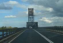
The Harwood Bridge is a steel truss bridge which carries the Pacific Highway over the Clarence River in the Northern Rivers region of New South Wales, Australia.[1]
Description
It crosses the main channel of the Clarence River, about 10 kilometres (6.2 mi) upstream from the river mouth, and 46 kilometres (29 mi) by road from Grafton. It is located 6 kilometres (3.7 mi) from the town of Maclean at the village of Harwood. It carries the Pacific Highway from the south bank of the Clarence River onto Harwood Island, from where the Highway crosses the Serpentine Channel onto Chatsworth Island then finally crosses the North Channel of the Clarence River via the Mororo Bridge (also a steel truss bridge) to the northern bank.
The Harwood Bridge was completed in August 1966, and replaced the last ferry crossing on the state highway system of New South Wales. Prior to the opening of the bridge, the river crossing was provided by three cable-guided ferries operating in parallel.
The bridge has a total length of 888 metres (2,913 ft), consisting of seven steel truss spans of 43.1 metres (141 ft) length and twenty-seven steel girder approach spans. The deck carries two lanes of traffic and a footway. One of the steel truss spans is a vertical-lift span, which allows ships to navigate the Clarence River. However, this now occurs infrequently.
The Harwood Bridge forms part of a bypass of the town of Maclean and the village of Harwood. It is the longest, and last, in a series of steel truss bridges of a standard design built by the then-Department of Main Roads during the 1950s and 1960s, chiefly across the wide coastal rivers of New South Wales, and mostly on the Pacific Highway. Bridges of the same design were built on the Pacific Highway across the Hunter River at Hexham (1952), the South Channel of the Hunter River at Mayfield (1965, demolished 2009), the Karuah River at Karuah (1957), the Wollamba River as part of the Nabiac bypass (1958, demolished 2004), the Hastings River as part of the Port Macquarie bypass (1961), and the Macleay River at Kempsey (1959).
See also
References
- ↑ "Harwood Bridge". Roads and Traffic Authority. Government of New South Wales. Archived from the original on 27 December 2009. Retrieved 3 January 2010.
External links
- Harwood Bridge overhaul project (c. 2009). Roads and Maritime Services, New South Wales.