Gwydir Highway
| Gwydir Highway New South Wales | |
|---|---|
.JPG) | |
| The Gwydir River Bridge on the highway at Gravesend. | |
 | |
| General information | |
| Type | Highway |
| Length | 566 km (352 mi)[1] |
| Opened | 1928 |
| Route number(s) |
|
| Former route number |
|
| Major junctions | |
| West end | |
|
| |
| East end | |
| Location(s) | |
| Major settlements | Collarenebri, Moree, Warialda, Inverell, Glen Innes |
| Highway system | |
|
Highways in Australia National Highway • Freeways in Australia Highways in New South Wales | |
| |
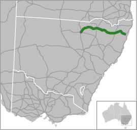
The Gwydir Highway is a 566-kilometre (352 mi)[1] state highway in northern New South Wales, Australia.
The highway was named after the Gwydir River, which in turn was named for a locale in Wales.
Route
.JPG)
The Gwydir Highway traverses the New England region from the inland plains to the coastal region, linking the Castlereagh Highway, Collarenebri, Moree, Warialda, Inverell, Glen Innes and Grafton. The western termination of the highway is at the junction of the Castlereagh Highway, 14 kilometres (8.7 mi) north of Walgett.[3]
At Moree it intersects the Newell Highway. At Inverell it has an intersection with Thunderbolts Way. At Glen Innes it intersects the New England Highway. At Grafton on the Clarence River, it joins the Pacific Highway, the Summerland Way and the Orara Way. Between Glen Innes and Grafton, the Gwydir Highway runs between the Gibraltar Range and Washpool National Parks.
Major junctions
| LGA | Location | km[1] | mi | Destinations | Notes | |
|---|---|---|---|---|---|---|
| Walgett | Walgett | 0 | 0.0 | Y-intersection; western terminus; road continues north and south as the Castlereagh Highway | ||
| Collarenebri | 60 | 37 | Wilson Street | 4-way intersection; Gwydir Highway continues east | ||
| Barwon River | Rocky Ford Bridge | |||||
| Moree Plains | Moree | 200 | 120 | Balo Street to Boggabilla Road to Carnarvon Highway – Mungindi, St George (QLD) | 4-way intersection; Gwydir Highway continues south | |
| Mehi River | Doctor Geoffrey Hunter Bridge | |||||
| Moree Plains | Moree | 201 | 125 | Roundabout; western concurrency terminus; Gwydir Highway continues east | ||
| Roundabout | ||||||
| T-intersection; eastern concurrency terminus; Gwydir Highway continues east | ||||||
| Gwydir River | 257 | 160 | Gwydir River Bridge | |||
| Gwydir | Warialda | 277 | 172 | T-ntersection; western concurrency terminus; Gwydir Highway continues east | ||
| 279 | 173 | T-intersection; eastern concurrency terminus; Gwydir Highway continues east | ||||
| Macintyre River | 340 | 210 | Bridge over the river (bridge name unknown) | |||
| Inverell | Inverell | 340 | 210 | Otho Street | Roundabout; Gwydir Highway continues southeast | |
| 341 | 212 | Tinga Road to Thunderbolts Way (no shield) – Uralla, Walcha, Gloucester | T-intersection: Gwydir Highway continues east | |||
| Glen Innes Severn | Glen Innes | 407 | 253 | T-intersection; northern concurrency terminus; Gwydir Highway continues south | ||
| Roundabound; southern concurrency terminus; Gwydir Highway continues east | ||||||
| Beardy Waters | 413 | 257 | Bridge over the river (bridge name unknown) | |||
| Mann River | 522 | 324 | Bridge over the river (bridge name unknown) | |||
| Clarence Valley | Grafton | 565 | 351 | Bent Street to | Roundabound; Gwydir Highway continues east | |
| T-intersection; eastern terminus; road continues north and south as the Pacific Highway | ||||||
1.000 mi = 1.609 km; 1.000 km = 0.621 mi
| ||||||
See also
References
- 1 2 3 Gwydir Highway, Walgett NSW 2832 to Charles Street, South Grafton NSW 2460 (Map). Google Maps. 2016. Retrieved 11 November 2016.
- ↑ Alpha Numeric route numbers - A new Road Numbering System, NSW Transport Roads & Maritime Services. Retrieved on 6 October 2012.
- ↑ "Gwydir Highway". Ozroads. Retrieved 21 June 2011.