Mount Lindesay Highway
| Mount Lindesay Highway Mount Lindesay Road - Beaudesert Road Queensland | |
|---|---|
 | |
| Mount Lindesay Highway (green and black) | |
| General information | |
| Type | Highway |
| Length | 116 km (72 mi) |
| Route number(s) |
|
| Major junctions | |
| North end |
Moorooka, Brisbane |
|
| |
| South end |
|
| Location(s) | |
| Major settlements | Jimboomba, Beaudesert, Rathdowney |
| Highway system | |
|
Highways in Australia National Highway • Freeways in Australia Highways in Queensland | |
| |
The Mount Lindesay Highway is an Australian national highway located in Queensland, also known as National Route 13.[1] The highway runs southwest from Brisbane, where it leaves Ipswich Road in the suburb of Moorooka (as Beaudesert Road to the Logan Motorway), to the Queensland – New South Wales border and is approximately 116 kilometres (72 mi) in length.[2] For most of its length it is roughly aligned with the Sydney–Brisbane rail corridor. At its southern end these transport routes take different passes over the Scenic Rim into the Northern Rivers region.
Location and route

Until 1954, the route was part of the New England Highway between Sydney and Brisbane. However, the opening of the road from Tenterfield to Wallangarra created a better road for the New England Highway and this route was renamed the Mount Lindesay Highway.[3] Until 1977, the Mount Lindesay Highway as a named road extended beyond the Queensland – New South Wales border to Tenterfield but the New South Wales section of the road, which still includes some unpaved portions, was decommissioned as a highway by the New South Wales Government due to very low traffic volumes. Approximately 8 kilometres (5.0 mi) south of the Queensland – New South Wales border the decommissioned part of the Mount Lindesay Highway intersects the northern end of the Summerland Way, known as New South Wales route B91, which runs south to Casino and then on to Grafton.
South of Rathdowney the highway becomes very winding as it climbs the McPherson Range. However it is a scenic road, and connects to the northern end of the Lions Road, a scenic drive between Innisplain and the Summerland Way just south of Roseberry, passing Mount Chinghee National Park, Mount Barney National Park and Border Ranges National Park on the way.
The highway is named after Mount Lindesay, the residue of a solidified magma core, that is part of the Mount Warning volcanic area and is situated in the western extreme of Border Ranges National Park.
Until the 1950s it formed part of the main traffic route between Brisbane and Sydney. The coastal route (now the Pacific Highway) was not favoured due to the large number of ferry crossings of the wide coastal rivers, the frequency and severity of flooding of these rivers and the consequent poor state of much of the road for extended periods, and its steep, winding nature as it crossed the intermediate hills between each river valley. In the mid-1950s a sealed road was constructed west from Boonah through Cunninghams Gap to Warwick, and this supplanted the Mount Lindesay Highway as the main Brisbane – Sydney traffic route as far south as Tenterfield. This in turn has since the 1980s been supplanted by the Pacific Highway as the major Brisbane – Sydney route, as a result of extensive upgrading and deviations of the Pacific Highway.
Between 2007 and 2009 4.5 kilometres (2.8 mi) of the highway in the Logan City local government area was upgraded.[4] As well as providing dual carriageways, the work included building service roads so that local traffic does not have to travel on the main carriageways, thereby reducing congestion.
List of towns, suburbs and localities on the Mount Lindesay Highway
From north to south, the following towns, suburbs and localities are either bounded by or passed through by the Mount Lindesday Highway:
|
|
|
Major intersections
| LGA | Location | km | mi | Destinations | Notes |
|---|---|---|---|---|---|
| Brisbane | Moorooka | 0 | 0.0 | north-east - Annerley | North-eastern end of National Route 13, which commences as Beaudesert Road, and becomes Mount Lindesay Highway after it crosses the Logan Motorway |
| Moorooka / Salisbury boundary | 2.2 | 1.4 | |||
| Rocklea / Salisbury / Archerfield / Coopers Plains boundary | 4.0 | 2.5 | |||
| Archerfield / Coopers Plains boundary | 5.1 | 3.2 | Boundary Road - west - Archerfield | ||
| Acacia Ridge | 8.6 | 5.3 | south - Algester | ||
| Acacia Ridge / Algester / Sunnybank Hills boundary | 9.1 | 5.7 | Hellawell Road - east- Sunnybank Hills | Northern concurrency terminus with State Route 30 | |
| Sunnybank Hills / Calamvale boundary | 10.8 | 6.7 | Southern concurrency terminus with State Route 30 | ||
| Parkinson / Drewvale boundary | 15.0 | 9.3 | west - Parkinson | Partial cloverleaf interchange. National Route 13 becomes Mount Lindsay Highway from this point. | |
| Logan | Parkinson / Hillcrest / Browns Plains boundary | 16.6 | 10.3 | Johnson Road - west - Hillcrest | Modified diamond interchange. |
| Park Ridge | 21.2 | 13.2 | Crest Road - west - Greenbank | Modified diamond interchange. | |
| Munruben / North Maclean boundary | 28.0 | 17.4 | Crowson Lane - west - North Maclean | Modified diamond interchange. | |
| Jimboomba | 34.9 | 21.7 | |||
| Scenic Rim | Beaudesert | 57.6 | 35.8 | Northern concurrency terminus with State Route 90 | |
| 58.0 | 36.0 | Southern concurrency terminus with State Route 90 | |||
| Rathdowney | 90.0 | 55.9 | |||
| Mount Lindesay / Mount Barney boundary | 116.0 | 72.1 | South-western end of National Route 13. The road continues into New South Wales as the Summerland Way. | ||
1.000 mi = 1.609 km; 1.000 km = 0.621 mi
| |||||
Gallery
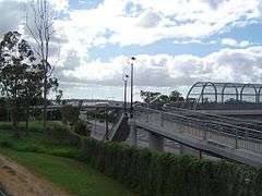 Overpass and footbridge at Hillcrest, Logan City, 2014
 Mount Lindesay, located adjacent to the Mount Lindesay Highway.
 Maclean Bridge at North Maclean, 2014
See also
References
- ↑ Queensland Government - Department of Transport and Main Roads - Maps
- ↑ Hema, Maps (2007). Australia Road and 4WD Atlas (Map). Eight Mile Plains Queensland: Hema Maps. pp. 6–7. ISBN 978-1-86500-456-3.
- ↑ "Munruben". Suburbs. Logan City Council. Retrieved 8 May 2014.
- ↑ Gomez, Kevin (7 December 2009). "Mount Lindesay Highway upgrade in Logan completed". Road Construct. Reed Business Information. Retrieved 16 July 2010.
External links
| Wikimedia Commons has media related to Mount Lindesay Highway. |
- Mt Lindesay Highway, ozroads