Warrego Highway
| Warrego Highway Queensland | |
|---|---|
 | |
| Warrego Highway (green on black) | |
| General information | |
| Type | Highway |
| Length | 715 km (444 mi) |
| Route number(s) |
(Mitchell Highway - Landsborough Highway) (Landsborough Highway - Pine Mountain Road, Brassall) (Pine Mountain Road, Brassall - Ipswich Motorway) |
| Major junctions | |
| NW end |
|
|
| |
| SE end |
|
| Location(s) | |
| Major settlements | Morven, Mitchell, Roma, Miles, Dalby, Toowoomba |
| Highway system | |
|
Highways in Australia National Highway • Freeways in Australia Highways in Queensland | |
| |
The Warrego Highway is located in southern Queensland, Australia. It connects coastal centres to the south western areas of the state, and is approximately 750 km in length. It takes its name from the Warrego River, which is the endpoint of the highway. The entire highway is part of the National Highway system linking Darwin and Brisbane: formerly National Highway 54, Queensland began to convert to the alphanumeric system much of Australia had adopted in the early-2000s and is now designated as National Highway A2.
Route description
The highway commences at the end of the M2 Ipswich Motorway, near Ipswich, and climbs the Great Dividing Range to Toowoomba. After reaching the top of the Toowoomba Range, the highway passes through the city via Cohoe, James, Tor and Bridge streets (although many smaller vehicles prefer to turnoff at the top of the range and use Margaret Street). The Warrego then crosses the Darling Downs, bypassing the town of Oakey and then passing through the towns of Dalby, Chinchilla and Miles, in the Western Downs. The highway continues through the towns of Roma and Mitchell in the Maranoa Region of South West Queensland. After Morven, the highway's thoroughfare continues down the Landsborough Highway, with the western turnoff continuing the Warrego Highway down to its terminus at Charleville.
The first section of highway between Ipswich and Toowoomba is mostly motorway grade; a four lane divided highway with motorway-style on-ramps and off-ramps. After the final set of traffic lights in Toowoomba, the highway merges from 4 to 2 lanes (however, throughout 2017-2019, the highway will be duplicated up until Oakey)[1] Then, the highway mostly continues in a straight line with minimal turns. At Dalby, the highway briefly returns to 4 lanes (with a longer stretch of the highway to be duplicated in 2017). The Warrego then continues as a rural 2 lane highway, until Charleville.
Terrain
The Warrego Highway's lowest point along its length is 3.69 m just east of where it crosses the Bremer River near Ipswich, and its highest elevation is 665 m at the top of the Great Dividing Range in Toowoomba.[2]
Speed zones
- Ipswich Motorway - Blacksoil 100 km/h
- Blacksoil - Toowoomba Second Range Crossing Eastern Merge (In construction) 100 km/h, with a drop to 80 km/h and/or 60 km/h through some towns
- Withcott 60 km/h
- Great Dividing Range (Toowoomba) 60 km/h to 100 km/h
- Redwood - Wilsonton 60 km/h
- Cotswold Hills/Torrington - Charlton 70 km/h, briefly raised to 90 km/h through a part of Charlton
- Toowoomba - Kingsthorpe 90 km/h
- Kingsthorpe - Dalby 100 km/h except through Jondaryan, which is 80 km/h.
- Dalby - 60 km/h
- Dalby - Charleville 100 km/h except running through towns, which speeds can drop to 60 km/h
Towns along the route

From east to west, the highway passes through or close to the cities and major towns of:
- Ipswich (Bypassed)
- Gatton (Bypassed)
- Toowoomba
- Oakey (Bypassed)
- Dalby
- Chinchilla
- Miles
- Roma
- Mitchell
- Morven
- Charleville
Gallery
 Highway at Haigslea, 2014
 A signpost
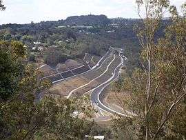 View from Picnic Point, 2014
History
In January 2011, the highway was extensively damaged where it crosses the Toowoomba Range. This included land slips, shoulder and embankment erosion, the erosion of drains and damaged rock fall netting.[3] The road wasn't fully repaired with all four lanes open until September 2011.[4]
Future developments
Toowoomba Second Range Crossing
The Toowoomba Second Range Crossing is a major road proposal aimed at bypassing the urban area of Toowoomba and providing a better crossing of the Great Dividing Range. The bypass will link the Warrego Highway at Helidon (in the east) with the highway at Charlton (in the west). The bypass will continue to the Gore Highway and will be 41 km in length. It is expected to be completed in late 2018.
Dalby Eastern & Western Access Upgrades
These upgrades will begin in 2017 and will fully duplicate the highway to 4 lanes, between Cecil Plains Road and Black Street. 4 new traffic signals will be added at Black Street, Jandowae Road, Orpen Street and a pedestrian signal near Owen Street.
Other items of interest
Darren Lockyer Way
On 28 September 2011 the Queensland Main Roads Minister, Craig Wallace, announced that an 85 km stretch of the Warrego Highway will be renamed Darren Lockyer Way, in honour of the retired Brisbane Broncos, Queensland and Australian rugby league captain. The section of road to be renamed is from Riverview to the bottom of the Toowoomba Range at Withcott. Special signage including "Welcome to Darren Lockyer Way" has been erected.[5]
The "Toll Bar"
The section of the Warrego Highway from Withcott to the top of the Toowoomba Range was first opened in January, 1855 as a toll road, named Toll Bar Road.[6] The toll collection point was marked by a bar across the road and a fence on either side. The upper section of Toll Bar Road was initially unsealed and very steep, with grades up to 14%. This road remained in use until December, 1939, when work on a new, less steep, upper section was completed. Part of the upper section is now a suburban street named Old Toll Bar Road.[7] The term "The Toll Bar" is sometimes used by locals to describe the current road, and it is also used in the mapping software distributed with Navman GPS systems.
Major intersections
| LGA | Location | km | mi | Destinations | Notes |
|---|---|---|---|---|---|
| Ipswich | Riverview | 0 | 0.0 | South-eastern end of Warrego Highway (State Route M2 / National Highway A2) | |
| Karalee / Chuwar / North Tivoli boundary | 6.3 | 3.9 | south - Tivoli | Modified diamond interchange. Part of Chuwar is in the Brisbane LGA. | |
| Brassal / Muirlea boundary | 12.9 | 8.0 | Pine Mountain Road - north - Pine Mountain | Modified diamond interchange. The road changes to National Highway A2 from this point. | |
| Blacksoil / Ironbark / Karrabin boundary | 15.4 | 9.6 | Wulkuraka Connection Road - south - Wulkuraka | Modified diamond interchange. | |
| Lockyer | Gatton | 55.9 | 34.7 | Gatton Esk Road - north - Esk | Modified diamond interchange. |
| Toowoomba | Toowoomba | 94.6 | 58.8 | Hume Street - south - Centenary Heights | Eastern concurrency terminus with New England Highway. |
| 95.1 | 59.1 | Ruthven Street - north - North Toowoomba | Western concurrency terminus with New England Highway. | ||
| Newtown / Harristown boundary | 97.3 | 60.5 | Anzac Avenue - north - Newtown | ||
| Oakey | 123.9 | 77.0 | |||
| Western Downs | Dalby | 175.9 | 109.3 | Eastern concurrency terminus with State Route 82. | |
| 179.3 | 111.4 | Condamine Street - south-west - Dalby | Eastern concurrency terminus with State Route 49. | ||
| 179.8 | 111.7 | Nicholson Street - north-east - Dalby | Western concurrency terminus with State Route 49. | ||
| 180.5 | 112.2 | Western concurrency terminus with State Route 82. | |||
| Miles | 305.5 | 189.8 | Eastern concurrency terminus with Leichhardt Highway. | ||
| 306.7 | 190.6 | Western concurrency terminus with Leichhardt Highway. | |||
| Maranoa | Roma | 440.7 | 273.8 | Eastern concurrency terminus with Carnarvon Highway. | |
| 446.7 | 277.6 | Western concurrency terminus with Carnarvon Highway. | |||
| Murweh | Morven | 627.7 | 390.0 | The road changes to Alternate National Highway A2 from this point. National Highway A2 continues as Landsborough Highway. | |
| Charleville | 714.5 | 444.0 | south - Cunnamulla | North-western end of Warrego Highway. | |
1.000 mi = 1.609 km; 1.000 km = 0.621 mi
| |||||
See also
References
- ↑ "Warrego Highway Upgrade Program: Toowoomba to Oakey Duplication Stage 2 (Leeson Road to Kingsthorpe)". Queensland Government - Department of Transport and Main Roads. Queensland Government. Retrieved 24 September 2016.
- ↑ "Map of Warrego Highway in Queensland". Bonzle Digital Atlas of Australia. Retrieved 22 September 2009.
- ↑ "Reconstruction at Toowoomba Range crossing, Warrego Highway". Queensland Reconstruction Authority. Queensland Government. Retrieved 5 August 2015.
- ↑ "Toowoomba Range lanes reopen as part of Operation Queenslander". Media Statement. Queensland Government. 16 September 2011. Retrieved 5 August 2015.
- ↑ Robyn Ironside (28 September 2011). "Stretch of Warrego Highway named after Darren Lockyer". The Courier Mail.
- ↑ Paul Rands. "Road Photos & Information: Queensland". Gateway Motorway, Logan Motorway, Ipswich Motorway, Warrego Highway, Landsborough Highway and Barkly Highway (M2/A2) - Toowoomba to Chinchilla. Retrieved 30 December 2011.
- ↑ "The Old Toll Bar". Geocaching Australia. Retrieved 30 December 2011.
External links
![]() Media related to Warrego Highway at Wikimedia Commons
Media related to Warrego Highway at Wikimedia Commons