Marion County, Oregon
| Marion County, Oregon | |
|---|---|
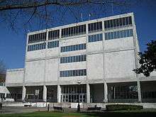 Marion County Courthouse in Salem | |
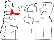 Location in the U.S. state of Oregon | |
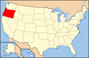 Oregon's location in the U.S. | |
| Founded | July 5, 1843 |
| Seat | Salem |
| Largest city | Salem |
| Area | |
| • Total | 1,194 sq mi (3,092 km2) |
| • Land | 1,184 sq mi (3,067 km2) |
| • Water | 10 sq mi (26 km2), 0.85% |
| Population (est.) | |
| • (2015) | 330,700 |
| • Density | 267/sq mi (103/km²) |
| Congressional district | 5th |
| Time zone | Pacific: UTC-8/-7 |
| Website |
www |
Marion County is a county located in the U.S. state of Oregon. The population was 315,335 at the 2010 census,[1] making it the fifth-most populous county in Oregon. The county seat is Salem,[2] the state capital. The county was originally named the Champooick District, after Champoeg (earlier Champooick[3]), a meeting place on the Willamette River. On September 3, 1849, the territorial legislature renamed it in honor of Francis Marion,[4] a Continental Army general from South Carolina who served in the American Revolutionary War.
Marion County is part of the Salem, OR Metropolitan Statistical Area, which is also included in the Portland-Vancouver-Salem, OR-WA Combined Statistical Area. It is located in the Willamette Valley.
History
Marion County was created by the Provisional Legislature of Oregon on July 5, 1843 as the Champooick District, one of the original four districts of the Oregon Country along with Twality (later Washington), Clackamas, and Yamhill counties. The four districts were redesignated as counties in 1845.
Originally, this political entity stretched southward to the California border and eastward to the Rocky Mountains. With the creation of Wasco, Linn, Polk, and other counties, its area was reduced in size. Marion County's present geographical boundaries were established in 1856.
In 1849, Salem was designated the county seat. The territorial capital was moved from Oregon City to Salem in 1852. The ensuing controversy over the location of the capital was settled in 1864 when Salem was confirmed as the state capital.
Geography
According to the U.S. Census Bureau, the county has a total area of 1,193 square miles (3,090 km2), of which 1,182 square miles (3,060 km2) is land and 10 square miles (26 km2) (0.9%) is water.[5]
Adjacent counties
- Linn County (south)
- Polk County (west)
- Yamhill County (northwest)
- Clackamas County (north)
- Wasco County (northeast)
- Jefferson County (east)
National protected areas
Demographics
| Historical population | |||
|---|---|---|---|
| Census | Pop. | %± | |
| 1850 | 2,749 | — | |
| 1860 | 7,088 | 157.8% | |
| 1870 | 9,965 | 40.6% | |
| 1880 | 14,576 | 46.3% | |
| 1890 | 22,934 | 57.3% | |
| 1900 | 27,713 | 20.8% | |
| 1910 | 39,780 | 43.5% | |
| 1920 | 47,187 | 18.6% | |
| 1930 | 60,541 | 28.3% | |
| 1940 | 75,246 | 24.3% | |
| 1950 | 101,401 | 34.8% | |
| 1960 | 120,888 | 19.2% | |
| 1970 | 151,309 | 25.2% | |
| 1980 | 204,692 | 35.3% | |
| 1990 | 228,483 | 11.6% | |
| 2000 | 284,834 | 24.7% | |
| 2010 | 315,335 | 10.7% | |
| Est. 2015 | 330,700 | [6] | 4.9% |
| U.S. Decennial Census[7] 1790-1960[8] 1900-1990[9] 1990-2000[10] 2010-2015[1] | |||
2000 census
As of the census of 2000,[11] there were 284,834 people, 101,641 households, and 70,437 families residing in the county. The population density was 241 people per square mile (93/km²). There were 108,174 housing units at an average density of 91 per square mile (35/km²). The racial makeup of the county was 81.62% White, 0.89% Black or African American, 1.44% Native American, 1.75% Asian, 0.36% Pacific Islander, 10.58% from other races, and 3.35% from two or more races. 17.10% of the population were Hispanic or Latino of any race. 18.4% were of German, 9.2% English, 8.2% American and 7.4% Irish ancestry. 80.8% spoke English, 14.8% Spanish and 1.4% Russian as their first language.
There were 101,641 households out of which 34.50% had children under the age of 18 living with them, 53.70% were married couples living together, 11.00% had a female householder with no husband present, and 30.70% were non-families. 24.00% of all households were made up of individuals and 9.50% had someone living alone who was 65 years of age or older. The average household size was 2.70 and the average family size was 3.19.
In the county, the population was spread out with 27.40% under the age of 18, 10.30% from 18 to 24, 28.70% from 25 to 44, 21.20% from 45 to 64, and 12.40% who were 65 years of age or older. The median age was 34 years. For every 100 females there were 101.10 males. For every 100 females age 18 and over, there were 99.50 males.
The median income for a household in the county was $40,314, and the median income for a family was $46,202. Males had a median income of $33,841 versus $26,283 for females. The per capita income for the county was $18,408. About 9.60% of families and 13.50% of the population were below the poverty line, including 18.10% of those under age 18 and 7.40% of those age 65 or over.
2010 census
As of the 2010 United States Census, there were 315,335 people, 112,957 households, and 77,044 families residing in the county.[12] The population density was 266.7 inhabitants per square mile (103.0/km2). There were 120,948 housing units at an average density of 102.3 per square mile (39.5/km2).[13] The racial makeup of the county was 78.2% white, 1.9% Asian, 1.6% American Indian, 1.1% black or African American, 0.7% Pacific islander, 12.6% from other races, and 3.9% from two or more races. Those of Hispanic or Latino origin made up 24.3% of the population.[12] In terms of ancestry, 22.1% were German, 11.4% were English, 11.0% were Irish, and 4.7% were American.[14]
Of the 112,957 households, 35.5% had children under the age of 18 living with them, 50.4% were married couples living together, 12.4% had a female householder with no husband present, 31.8% were non-families, and 25.0% of all households were made up of individuals. The average household size was 2.70 and the average family size was 3.23. The median age was 35.1 years.[12]
The median income for a household in the county was $46,069 and the median income for a family was $54,661. Males had a median income of $39,239 versus $32,288 for females. The per capita income for the county was $21,915. About 11.7% of families and 16.0% of the population were below the poverty line, including 23.8% of those under age 18 and 7.6% of those age 65 or over.[15]
Politics
| Year | Republican | Democratic |
|---|---|---|
| 2016 | 46.3% 63,377 | 42.2% 57,788 |
| 2012 | 50.0% 60,190 | 46.8% 56,376 |
| 2008 | 47.4% 59,059 | 49.6% 61,816 |
| 2004 | 53.9% 69,900 | 44.5% 57,671 |
| 2000 | 50.7% 57,443 | 43.6% 49,430 |
| 1996 | 43.2% 46,415 | 45.3% 48,637 |
| 1992 | 38.2% 42,145 | 37.3% 41,137 |
| 1988 | 51.2% 45,292 | 46.5% 41,193 |
| 1984 | 59.8% 54,535 | 40.0% 36,440 |
| 1980 | 49.4% 42,191 | 37.6% 32,134 |
| 1976 | 49.1% 35,497 | 46.7% 33,781 |
| 1972 | 57.5% 36,441 | 37.7% 23,908 |
| 1968 | 54.8% 30,417 | 40.2% 22,327 |
| 1964 | 36.9% 18,897 | 62.7% 32,091 |
| 1960 | 58.3% 29,124 | 41.6% 20,791 |
Marion is a historically Republican county that has become more competitive in the last 30 years. Although the Democrats won with pluralities in 1996 and 2008, no Democrat has carried a majority of the county since Lyndon Johnson in 1964.
Economy
Agriculture and food processing are important to the county's economy, as are lumber, manufacturing, and education. Marion County is the leader in agricultural production among all other Oregon counties.[17] Marion County has 10,640 acres (43 km²) planted in orchards. The Marionberry was named after the county. Government, however, is the county's main employer and economic base.
Education
Marion County is the home of Willamette University, Corban University, and Chemeketa Community College.[17]
Communities
Cities
Census-designated places
Unincorporated communities
See also
References
- 1 2 "State & County QuickFacts". United States Census Bureau. Retrieved November 15, 2013.
- ↑ "Find a County". National Association of Counties. Retrieved 2011-06-07.
- ↑ Horner, John B. "Oregon: Her History, Her Great Men, Her Literature". Portland, Oregon: The J.K. Gill Co., 1919, p. 98.
- ↑ Gannett, Henry (1905). The Origin of Certain Place Names in the United States. U.S. Government Printing Office. p. 200.
- ↑ "2010 Census Gazetteer Files". United States Census Bureau. August 22, 2012. Retrieved February 26, 2015.
- ↑ "County Totals Dataset: Population, Population Change and Estimated Components of Population Change: April 1, 2010 to July 1, 2015". Retrieved July 2, 2016.
- ↑ "U.S. Decennial Census". United States Census Bureau. Retrieved February 26, 2015.
- ↑ "Historical Census Browser". University of Virginia Library. Retrieved February 26, 2015.
- ↑ Forstall, Richard L., ed. (March 27, 1995). "Population of Counties by Decennial Census: 1900 to 1990". United States Census Bureau. Retrieved February 26, 2015.
- ↑ "Census 2000 PHC-T-4. Ranking Tables for Counties: 1990 and 2000" (PDF). United States Census Bureau. April 2, 2001. Retrieved February 26, 2015.
- ↑ "American FactFinder". United States Census Bureau. Retrieved 2008-01-31.
- 1 2 3 "DP-1 Profile of General Population and Housing Characteristics: 2010 Demographic Profile Data". United States Census Bureau. Retrieved 2016-02-23.
- ↑ "Population, Housing Units, Area, and Density: 2010 - County". United States Census Bureau. Retrieved 2016-02-23.
- ↑ "DP02 SELECTED SOCIAL CHARACTERISTICS IN THE UNITED STATES – 2006-2010 American Community Survey 5-Year Estimates". United States Census Bureau. Retrieved 2016-02-23.
- ↑ "DP03 SELECTED ECONOMIC CHARACTERISTICS – 2006-2010 American Community Survey 5-Year Estimates". United States Census Bureau. Retrieved 2016-02-23.
- ↑ http://uselectionatlas.org/RESULTS/
- 1 2 "Marion County, Oregon".
Further reading
- H.O. Lang (ed.), History of the Willamette Valley: Being a Description of the Valley and its Resources, with an Account of its Discovery and Settlement by White Men, and its Subsequent History; Together with Personal Reminiscences of its Early Pioneers. Portland: Himes and Lang, 1885.
- Portrait and Biographical Record of the Willamette Valley, Oregon, Containing Original Sketches of Many Well Known Citizens of the Past and Present. Chicago: Chapman Publishing Co., 1903.
- Marion County Historical Society, Marion County History. (periodical)
Municipalities and communities of Marion County, Oregon, United States | ||
|---|---|---|
| Cities | | |
| CDPs | ||
| Unincorporated communities | ||
| Ghost towns | ||
| Footnotes | ‡This populated place also has portions in an adjacent county or counties | |
Coordinates: 44°55′N 122°35′W / 44.91°N 122.58°W