Curry County, Oregon
| Curry County, Oregon | |
|---|---|
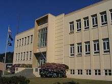 Curry County Courthouse in Gold Beach | |
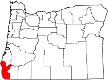 Location in the U.S. state of Oregon | |
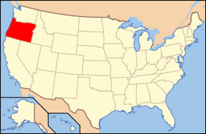 Oregon's location in the U.S. | |
| Founded | December 18, 1855 |
| Seat | Gold Beach |
| Largest city | Brookings |
| Area | |
| • Total | 1,988 sq mi (5,149 km2) |
| • Land | 1,627 sq mi (4,214 km2) |
| • Water | 361 sq mi (935 km2), 18.2% |
| Population (est.) | |
| • (2015) | 22,483 |
| • Density | 14/sq mi (5.3/km²) |
| Congressional district | 4th |
| Time zone | Pacific: UTC-8/-7 |
| Website |
www |
Curry County is a county in the U.S. state of Oregon. As of the 2010 census, the population was 22,364.[1] The county seat is Gold Beach.[2] The county is named for George Law Curry,[3] a governor of the Oregon Territory.
Curry County comprises the Brookings, OR Micropolitan Statistical Area.
Geography
According to the U.S. Census Bureau, the county has a total area of 1,988 square miles (5,150 km2), of which 1,627 square miles (4,210 km2) is land and 361 square miles (930 km2) (18%) is water.[4]
The westernmost point in Oregon is in Curry County at Cape Blanco located at 42°50′08″N 124°33′57″W / 42.835508°N 124.565939°W.
The county contains significant forests, with occurrence of black oak, big leaf maple and Douglas-fir. The blue oak, prevalent slightly further south does not reach into Curry County.[5]
Adjacent counties
- Coos County (north)
- Douglas County (northeast)
- Josephine County (east)
- Del Norte County, California (south)
National protected areas
Demographics
| Historical population | |||
|---|---|---|---|
| Census | Pop. | %± | |
| 1860 | 393 | — | |
| 1870 | 504 | 28.2% | |
| 1880 | 1,208 | 139.7% | |
| 1890 | 1,709 | 41.5% | |
| 1900 | 1,868 | 9.3% | |
| 1910 | 2,044 | 9.4% | |
| 1920 | 3,025 | 48.0% | |
| 1930 | 3,257 | 7.7% | |
| 1940 | 4,301 | 32.1% | |
| 1950 | 6,048 | 40.6% | |
| 1960 | 13,983 | 131.2% | |
| 1970 | 13,006 | −7.0% | |
| 1980 | 16,992 | 30.6% | |
| 1990 | 19,327 | 13.7% | |
| 2000 | 21,137 | 9.4% | |
| 2010 | 22,364 | 5.8% | |
| Est. 2015 | 22,483 | [6] | 0.5% |
| U.S. Decennial Census[7] 1790-1960[8] 1900-1990[9] 1990-2000[10] 2010-2015[1] | |||
2000 census
As of the census[11] of 2000, there were 21,137 people, 9,543 households, and 6,183 families residing in the county. The population density was 13 people per square mile (5/km²). There were 11,406 housing units at an average density of 7 per square mile (3/km²). The racial makeup of the county was 92.89% White, 0.15% Black or African American, 2.14% Native American, 0.70% Asian, 0.11% Pacific Islander, 1.11% from other races, and 2.90% from two or more races. 3.60% of the population were Hispanic or Latino of any race. 20.1% were of German, 13.8% English, 10.3% United States or American and 9.9% Irish ancestry. 95.9% spoke English and 2.5% Spanish as their first language.
There were 9,543 households out of which 20.90% had children under the age of 18 living with them, 54.50% were married couples living together, 7.20% had a female householder with no husband present, and 35.20% were non-families. 29.70% of all households were made up of individuals and 14.70% had someone living alone who was 65 years of age or older. The average household size was 2.19 and the average family size was 2.66.
In the county, the population was spread out with 19.20% under the age of 18, 4.80% from 18 to 24, 20.00% from 25 to 44, 29.40% from 45 to 64, and 26.60% who were 65 years of age or older. The median age was 49 years. For every 100 females there were 96.60 males. For every 100 females age 18 and over, there were 94.80 males.
The median income for a household in the county was $30,117, and the median income for a family was $35,627. Males had a median income of $31,772 versus $22,416 for females. The per capita income for the county was $18,138. About 9.70% of families and 12.20% of the population were below the poverty line, including 13.60% of those under age 18 and 10.60% of those age 65 or over.
2010 census
As of the 2010 United States Census, there were 22,364 people, 10,417 households, and 6,347 families residing in the county.[12] The population density was 13.7 inhabitants per square mile (5.3/km2). There were 12,613 housing units at an average density of 7.8 per square mile (3.0/km2).[13] The racial makeup of the county was 92.0% white, 1.9% American Indian, 0.7% Asian, 0.3% black or African American, 0.1% Pacific islander, 1.3% from other races, and 3.7% from two or more races. Those of Hispanic or Latino origin made up 5.4% of the population.[12] In terms of ancestry, 26.3% were German, 16.2% were English, 14.1% were Irish, 6.2% were American, and 5.2% were Swedish.[14]
Of the 10,417 households, 18.9% had children under the age of 18 living with them, 48.6% were married couples living together, 8.4% had a female householder with no husband present, 39.1% were non-families, and 32.4% of all households were made up of individuals. The average household size was 2.12 and the average family size was 2.62. The median age was 53.5 years.[12]
The median income for a household in the county was $37,469 and the median income for a family was $53,340. Males had a median income of $41,667 versus $27,188 for females. The per capita income for the county was $23,842. About 9.2% of families and 13.9% of the population were below the poverty line, including 19.0% of those under age 18 and 8.0% of those age 65 or over.[15]
Economy

In 1852 explorers discovered gold and other precious metals in the rivers and along the beaches of this area. As a result, settlement in the county was concentrated along the coast, depending primarily on water transportation. The slow development of inland transportation routes kept the county relatively isolated well into the twentieth century. While there is still some mining of cobalt, nickel, and chromium in the Gasquet Mountain area, the economy has reoriented to agriculture and timber.[16] Port Orford cedar (also known as Lawson's Cypress) and myrtlewood are important export products.[17]
The county has excellent grazing areas for raising cattle and sheep. The county also produces blueberries, horticultural nursery stock, and 90% of all Easter lilies raised in the United States. In 2001, the native tanoak in the county were afflicted by Sudden oak death, caused by infection of Phytophthora ramorum, which has threatened the success of the local nurseries; however, the infection has been successfully contained to an area 12 miles (19 km) in size. Tourism is also important to Curry County. The Forest Service owns 59% of the land within the county boundaries. The Port of Brookings is considered one of the safest harbors on the coast.
Communities
Cities
- Brookings
- Gold Beach (county seat)
- Port Orford
Census-designated places
Unincorporated communities
- Agness
- Bagnell Ferry
- Carpenterville
- Denmark
- Hunter Creek
- Illahe
- Marial
- Ophir
- Plum Trees
- Sixes
- Wedderburn
See also
- National Register of Historic Places listings in Curry County, Oregon
- Siskiyou National Forest
- USS Curry County (LST-685)
References
- 1 2 "State & County QuickFacts". United States Census Bureau. Retrieved November 14, 2013.
- ↑ "Find a County". National Association of Counties. Archived from the original on May 31, 2011. Retrieved 2011-06-07.
- ↑ Gannett, Henry (1905). The Origin of Certain Place Names in the United States. Govt. Print. Off. p. 97.
- ↑ "2010 Census Gazetteer Files". United States Census Bureau. August 22, 2012. Retrieved February 25, 2015.
- ↑ C. Michael Hogan (2008) Blue Oak: Quercus douglasii, GlobalTwitcher.com, ed. N. Stromberg
- ↑ "County Totals Dataset: Population, Population Change and Estimated Components of Population Change: April 1, 2010 to July 1, 2015". Retrieved July 2, 2016.
- ↑ "U.S. Decennial Census". United States Census Bureau. Archived from the original on May 11, 2015. Retrieved February 25, 2015.
- ↑ "Historical Census Browser". University of Virginia Library. Retrieved February 25, 2015.
- ↑ Forstall, Richard L., ed. (March 27, 1995). "Population of Counties by Decennial Census: 1900 to 1990". United States Census Bureau. Retrieved February 25, 2015.
- ↑ "Census 2000 PHC-T-4. Ranking Tables for Counties: 1990 and 2000" (PDF). United States Census Bureau. April 2, 2001. Retrieved February 25, 2015.
- ↑ "American FactFinder". United States Census Bureau. Archived from the original on September 11, 2013. Retrieved January 31, 2008.
- 1 2 3 "DP-1 Profile of General Population and Housing Characteristics: 2010 Demographic Profile Data". United States Census Bureau. Retrieved 2016-02-23.
- ↑ "Population, Housing Units, Area, and Density: 2010 - County". United States Census Bureau. Retrieved 2016-02-23.
- ↑ "DP02 SELECTED SOCIAL CHARACTERISTICS IN THE UNITED STATES – 2006-2010 American Community Survey 5-Year Estimates". United States Census Bureau. Retrieved 2016-02-23.
- ↑ "DP03 SELECTED ECONOMIC CHARACTERISTICS – 2006-2010 American Community Survey 5-Year Estimates". United States Census Bureau. Retrieved 2016-02-23.
- ↑ Gold Beach Oregon & Curry County Area in Southern Oregon. , Retrieved May 18, 2013.
- ↑ Oregon Historical County Records Guide. , Retrieved May 18, 2013.
External links
| Wikimedia Commons has media related to Curry County, Oregon. |
 |
Coos County | Douglas County | | |
| Pacific Ocean | |
Josephine County | ||
| ||||
| | ||||
| Del Norte County, California |
Municipalities and communities of Curry County, Oregon, United States | ||
|---|---|---|
| Cities | | |
| CDPs | ||
| Other unincorporated communities | ||
Coordinates: 42°28′48″N 124°08′12″W / 42.48000°N 124.13667°W