Pratum, Oregon
| Pratum | |
|---|---|
| Unincorporated community | |
|
Pratum as seen from Howell Prairie Road | |
 Pratum  Pratum Location within the state of Oregon | |
| Coordinates: 44°57′33″N 122°52′39″W / 44.95917°N 122.87750°WCoordinates: 44°57′33″N 122°52′39″W / 44.95917°N 122.87750°W | |
| Country | United States |
| State | Oregon |
| County | Marion |
| Time zone | Pacific (PST) (UTC-8) |
| • Summer (DST) | PDT (UTC-7) |
| ZIP code | 97305 |
| Area code(s) | 503 and 971 |
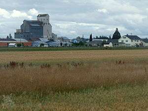
Pratum is an unincorporated community in Marion County, Oregon, United States. It is located northeast of Salem on Howell Prairie near the Pudding River. Pratum is Latin for "meadow".[1] The community was settled in the late 19th century by a group of Mennonites, many of them of Swiss extraction.[2][3] A branch of the narrow-gauge Oregonian Railway was built through the area in about 1880, and the station there was called "East Side Junction".[1] The railway was eventually converted to standard gauge, and is still in use today by the Willamette Valley Railway. In 1895, the station was renamed "Enger" by a Mr. Larson, who opened the first store there. "Enger" was confused with Eugene, however, and the name of the station changed to "Pratum" in 1898.[1] Pratum post office was established in 1887, and was originally called "Switzerland", then "Enger" and finally "Pratum" in 1898, matching the railroad station.[1] The post office ran until 1964.[1] Pratum School, built in 1928 and part of the Silver Falls School District, is still operating.[4]
The community is part of the Salem Metropolitan Statistical Area.

References
- 1 2 3 4 5 McArthur, Lewis A.; Lewis L. McArthur (2003) [1928]. Oregon Geographic Names (Seventh ed.). Portland, Oregon: Oregon Historical Society Press. p. 783. ISBN 0-87595-277-1.
- ↑ Global Anabaptist Mennonite Encyclopedia Online: Oregon (State)
- ↑ Salem Online History
- ↑ Silverton Chamber of Commerce
External links
 Media related to Pratum, Oregon at Wikimedia Commons
- Pratum Elementary School
- Historic images of Pratum from Salem Public Library
Municipalities and communities of Marion County, Oregon, United States | ||
|---|---|---|
| Cities | 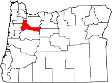 | |
| CDPs | ||
| Unincorporated communities | ||
| Ghost towns | ||
| Footnotes | ‡This populated place also has portions in an adjacent county or counties | |