Oregon City, Oregon
| City of Oregon City | ||
|---|---|---|
| City | ||
| ||
| Nickname(s): End of the Oregon Trail, OC | ||
| Motto: Urbs civitatis nostrae prima et mater (English: First and mothertown of our state) | ||
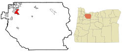 Location in Oregon | ||
| Coordinates: 45°21′26″N 122°36′26″W / 45.35722°N 122.60722°WCoordinates: 45°21′26″N 122°36′26″W / 45.35722°N 122.60722°W | ||
| Country | United States | |
| State | Oregon | |
| County | Clackamas | |
| Founded | 1829 | |
| Incorporated | 1844 | |
| Government | ||
| • Mayor | Dan Holladay | |
| Area[1] | ||
| • Total | 9.29 sq mi (24.06 km2) | |
| • Land | 9.05 sq mi (23.44 km2) | |
| • Water | 0.24 sq mi (0.62 km2) | |
| Elevation | 141 ft (42 m) | |
| Population (2010)[2] | ||
| • Total | 31,859 | |
| • Estimate (2013[3]) | 34,622 | |
| • Density | 3,520.3/sq mi (1,359.2/km2) | |
| Time zone | PST (UTC-8) | |
| • Summer (DST) | PDT (UTC-7) | |
| ZIP code | 97045 | |
| Area code(s) | 503 and 971 | |
| FIPS code | 41-55200 | |
| GNIS feature ID | 1136601[4] | |
| Website | www.orcity.org | |
Oregon City is the county seat of Clackamas County, Oregon, United States, located on the Willamette River near the southern limits of the Portland metropolitan area. Established in 1829 by the Hudson's Bay Company, in 1844 it became the first U.S. city west of the Rocky Mountains to be incorporated. As of the 2010 census, the city population was 31,859.
History
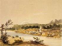
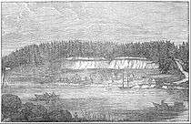
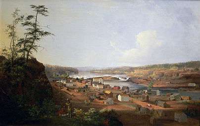
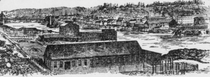
Known in recent decades as the site of several large paper mills on the Willamette River, the city played a significant role in the early history of the Oregon Country. It was established by Hudson's Bay Company's Dr. John McLoughlin in 1829 near the confluence of the Clackamas River with the Willamette to take advantage of the power of Willamette Falls to run a lumber mill. During the 1840s and 1850s it was the destination for those wanting to file land claims after traveling the Oregon Trail as the last stop on the trail.[5][6]
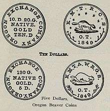
It was the capital of the Oregon Territory from its establishment in 1848 until 1851, and rivaled Portland for early supremacy in the area. In 1846, the city's newspaper, the Oregon Spectator, was the first American newspaper to be published west of the Rocky Mountains. Oregon City College was established in 1849 as a Baptist school, but was defunct by the 1870s.[7] Oregon City was the site of the Beaver Coins Mint, producing the short-lived independent Oregon Territory currency in 1849.[8]
The center of the city retains part of its historic character through the preservation of houses and other buildings from the era of the city's founding.
Former Latin archdiocese
The town became the see city of the first Roman Catholic archdiocese in the western United States, when the diocese of Oregon City, established in 1846, was raised to metropolitan rank, with Archbishop François Norbert Blanchet as its ordinary. Its territory included all of the western United States. The population in the area of Oregon City declined due to the California Gold Rush. That of nearby Portland grew, and the headquarters of the archdiocese was moved there in 1926. In 1928 the name Archdiocese of Portland in Oregon replaced the former name. No longer a residential bishopric, Oregon City is now a titular see.[9][10]
Neighborhoods
Oregon City has several neighborhoods represented by official neighborhood associations:[11]
- The Park Place neighborhood is in the northeastern corner of the city, located on a bluff overlooking Abernethy Green. The neighborhood includes a housing project, as well as numerous rural properties. Park Place, formerly an independent community, also includes unincorporated areas outside the city limits. First called Clackamas (a name that was later given to a community three miles north), then Paper Mill, the community was finally named Park Place for a park in a nearby oak grove. Park Place was platted in 1889, and a post office was established the following year. For a while the name was changed to "Parkplace."[12]
- The Two Rivers neighborhood is the primarily commercial lowest-elevation area of town including downtown Oregon City, the End of the Oregon Trail Visitor's Center at Abernethy Green, and Clackamette Park. It borders the Clackamas and Willamette rivers to the north and west and Park Place to the east and McLoughlin to the south. I-205 runs through the north part of the neighborhood.
- The McLoughlin neighborhood is bordered by Washington Street and Singer Hill on the Northwest, a bluff overlooking Abernethy Creek on the northeast and east, and Division Street on the south. It also includes extends to the west to border the Canemah district. The John McLoughlin House and the upper entrance to the Municipal Elevator are located in this neighborhood.
- The Barclay Hills neighborhood lies between Rivercrest Park on the west, the city limits on the east, the McLoughlin Neighborhood on the north, and Warner-Milne Road on the south. This neighborhood is bisected by Molalla Avenue, the former route of Oregon Route 213 before it was moved to the Oregon City Bypass to the east.
- The Canemah neighborhood lies along Oregon Route 99E, and is a narrow strip of land sandwiched between the Willamette River and a bluff. Canemah was once an independent city before being annexed into Oregon City. Canemah was founded in 1845 and was the portage site around Willamette Falls for many years. It was supposedly named after an Indian chief.[12]
- The Rivercrest neighborhood includes Rivercrest Park, and the residential communities overlooking the Willamette River to the west.
- The South End neighborhood lies to the southwest of Rivercrest Park. It centers around the intersection of South End and Warner-Parrot roads, and was the location of Oregon City's (now defunct) drive-in movie theater.
- The Hazel Grove/Westling Farm neighborhood lies in the southwestern corner of the city, lying between the bluffs over the Willamette River and the unincorporated areas to the south.
- The Tower Vista neighborhood lies southeast of South End, and east of Hazel Grove/Whistling Farm. It is bordered on the east and southeast by Leland Road.
- The Hillendale neighborhood lies south of Warner-Milne Road, east of Leland Road, north of Clairmont Way and Beavercreek Road, and west of OR 213 and the city limits. The former site of City Hall is located here, as is the Clackamas County jail.
- The Gaffney Lane neighborhood, centered around the elementary school of the same name, lies south of Hillendale, west of OR 213, and north/east of the city limits.
- The Caufield neighborhood contains those parts of the city located south of Park Place, and east of OR 213. Clackamas Community College is located here, as is Oregon City High School.
| ||||||
Geography
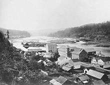
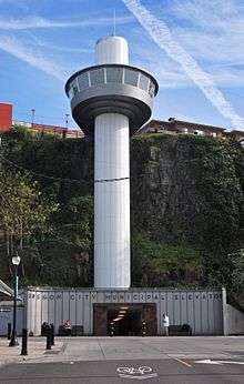
The town is divided into upper and lower areas. The lower area is on a bench next to the Willamette River. The upper area is atop a bluff composed of Canemah basalt, which flowed about 2.5 million years ago from a vent 7.5 miles (12 km) to the southeast in the Boring Lava Field.[13] For many years, Indian trails connected the two levels, but stairs were built in the 19th century. In 1915 the town built the water-powered Oregon City Municipal Elevator to connect the two parts, which was converted to electricity in the 1920s. In 1952, a new electric elevator was constructed with the specification that it was to be "as plain as possible and without ornament."[14]
According to the United States Census Bureau, the city has a total area of 9.29 square miles (24.06 km2), of which, 9.05 square miles (23.44 km2) is land and 0.24 square miles (0.62 km2) is water.[1] The major waterways of Oregon City include the Willamette River, which flows along the northwest side of the city, and the Clackamas River, which merges with the larger Willamette to the north of the city. The Willamette forms the boundary between Oregon City and West Linn; the Clackamas serves as the boundary between Oregon City and Gladstone.
Willamette Falls
The Willamette Falls Locks in West Linn were the first multi-lift navigational locks in the United States and are now a National Historical Site, no longer in use. The first long-distance electrical service in the United States originated in Oregon City, transmitting electricity 14 miles (23 km) to Portland.
Climate
| Climate data for Oregon City, Oregon | |||||||||||||
|---|---|---|---|---|---|---|---|---|---|---|---|---|---|
| Month | Jan | Feb | Mar | Apr | May | Jun | Jul | Aug | Sep | Oct | Nov | Dec | Year |
| Record high °F (°C) | 66 (19) |
75 (24) |
81 (27) |
92 (33) |
104 (40) |
103 (39) |
108 (42) |
107 (42) |
105 (41) |
96 (36) |
75 (24) |
68 (20) |
108 (42) |
| Average high °F (°C) | 48.5 (9.2) |
53.0 (11.7) |
58.3 (14.6) |
63.6 (17.6) |
70.4 (21.3) |
76.0 (24.4) |
83.3 (28.5) |
83.7 (28.7) |
78.0 (25.6) |
65.1 (18.4) |
53.1 (11.7) |
46.5 (8.1) |
65.0 (18.3) |
| Average low °F (°C) | 36.5 (2.5) |
37.1 (2.8) |
39.8 (4.3) |
42.9 (6.1) |
47.9 (8.8) |
52.6 (11.4) |
56.5 (13.6) |
56.4 (13.6) |
52.2 (11.2) |
45.9 (7.7) |
40.3 (4.6) |
35.5 (1.9) |
45.3 (7.4) |
| Record low °F (°C) | −2 (−19) |
6 (−14) |
22 (−6) |
28 (−2) |
31 (−1) |
37 (3) |
41 (5) |
41 (5) |
33 (1) |
24 (−4) |
9 (−13) |
6 (−14) |
−2 (−19) |
| Average precipitation inches (mm) | 6.78 (172.2) |
4.62 (117.3) |
4.67 (118.6) |
3.47 (88.1) |
2.46 (62.5) |
1.74 (44.2) |
.65 (16.5) |
.72 (18.3) |
1.61 (40.9) |
3.61 (91.7) |
6.56 (166.6) |
7.32 (185.9) |
44.21 (1,122.9) |
| Source: [15] | |||||||||||||
Oregon City has a Mediterranean climate. The Mediterranean climate regime resembles the climate of the lands in the Mediterranean Basin, parts of western North America, parts of Western and South Australia, in southwestern South Africa and in parts of central Chile. The climate is characterized by hot, dry summers and cool, wet winters.
Economy
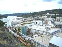
For much of its existence, Oregon City's economy has been dominated by the forestry industry, until the decline of the Pacific Northwest lumber industry started in the 1980s. At its height, several mills operated in the city and surrounding communities; all but one paper mill have been shuttered.
Today, the city is home to several notable high technology and light manufacturing concerns. Notable companies based in Oregon City include Benchmade, a manufacturer of high-end cutlery. Chrome Systems Corporation (formerly Chrome Data) was founded there, but has since moved to nearby Portland. Medrisk, LLC is a major insurance brokerage which does business in the Northwest and is headquartered in Oregon City.
In 2006 Anderson Vending Inc. chose Oregon City as its new headquarters.
Government
Oregon City was the capital of the Oregon Territory until 1851; the following governors served during that time:
- George Abernethy, provisional governor of the Oregon Country (1845–48)
- George Law Curry, journalist and acting territorial governor
- John P. Gaines, governor of Oregon territory, 1850–53. During his term (and against his wishes), the territorial capital of Oregon moved to Salem.
- Joseph Lane, first governor of the Oregon Territory, 1848–50; acting governor in 1853.
- Kintzing Prichette, acting governor, 1850
Education
The city, and several surrounding communities, is served by the Oregon City School District,[16] a public school district consisting of 10 elementary schools, two middle schools, a traditional four-year high school (Oregon City High School), and an alternative secondary school. Several schools in the district offer bilingual English/Spanish programs. Oregon City High School is the third most populated high school in Oregon, and is a state and national power in girls' basketball, winning three consecutive USA Today girls' national championships in the 1990s.
The city also is the home of Clackamas Community College, numerous private and parochial schools, and a public library that is part of the Library Information Network of Clackamas County.
Points of interest
Museums and historic buildings
Museums include the Museum of the Oregon Territory and the End of the Oregon Trail Interpretive Center, with costumed "living history" guides. The Clackamas County Historical Society archives, housed in the Museum of the Oregon Territory, also include the incorporation plat for the city of San Francisco. Clackamas Heritage Partners owns and operates these museums, along with the Stevens Crawford Museum. In 2009, Clackamas Heritage Partners announced that it could no longer afford to keep the museums open. The End of the Oregon Trail Interpretive Center was closed to the public indefinitely in September 2009, while the Stevens Crawford Museum and Museum of the Oregon Territory, which are staffed largely by volunteers, will operate on a limited schedule.[17] The End of the Oregon Trail Interpretive Center reopened, however, during the summer of 2013 thanks to grants and donations from numerous sources.[18]
The Stevens Crawford Museum is an 1908 structure with 15 furnished rooms, many with their original fittings, as the house was used as a home continuously until 1968. Other historical buildings in Oregon City include the McLoughlin House, the Ermatinger House (oldest in Clackamas County), the Ainsworth House, the Harvey Cross House, and the First Congregational Church. The 1922-built Oregon City Bridge, over the Willamette River, is listed on the National Register of Historic Places, as is the Oregon City Municipal Elevator.
Parks
Oregon City has over 22 city parks. One of the city's larger parks is Clackamette Park, at the confluence of the Clackamas and Willamette Rivers. The park's features include RV camping, a boat launch and dock, a skateboard park, and other recreational facilities. Several community festivals are held there throughout the year. Other major parks include Chapin, Hillendale, Rivercrest, and the new Wesley Lynn.
Transportation
The city is served by the following transportation links:
- Road
Interstate 205 passes through the city's northern edge, and is the only freeway to serve the city. In addition, three state highways (Oregon Route 43, Oregon Route 99E, and Oregon Route 213) pass through or terminate in Oregon City. The former two serve the city's downtown core, the latter provides service to the southern parts of Oregon City.
- Rail
The Union Pacific Railroad mainline passes through the city. The city also has an Amtrak station, which is served twice daily in each direction by Amtrak Cascades trains running between Portland and Eugene, Oregon. The Coast Starlight (Seattle-Los Angeles) passes through but does not stop.
- Air
There are no public airports within the city. A small private airfield is along Beavercreek Road, south of Oregon City. Oregon City is served by Portland International Airport, 15 miles (24 km) to the north, and by Portland-Mulino Airport, a general-aviation facility in the town of Mulino, approximately 15 miles (24 km) to the south.
- Water
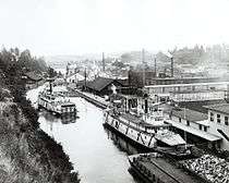
The Willamette River in Oregon City is navigable to small craft, and Oregon City has a thriving fishing and recreational boating industry. The Willamette Falls Locks allow boats to navigate around the falls. The Clackamas River is not navigable, except for the lowermost portions.
- Mass transit
As part of the greater Portland metropolitan area, Oregon City is served by TriMet, the regional transit authority, with several bus lines which converge at the Oregon City Transit Center. Until 1958, an interurban trolley line operated by the now-defunct Portland Traction Company connected Oregon City with Portland;[19] remnants of this line are still visible (such as an abandoned bridge across the Clackamas River, just east of the OR 99E bridge). In more recent years, the city operated a "historic trolley" service during the summer months, primarily to serve the needs of tourism, but the vehicles used were trolley-replica buses, rather than actual trolley cars, and in 2013 it was decided to discontinue that service and sell the vehicles.[20]
Two other public agencies provide transit service in Oregon City, supplementing that of TriMet. The South Clackamas Transportation District (SCTD) operates a route between Clackamas Community College on the south east end of Oregon City to Molalla, about 18 miles (29 km) south on Oregon Route 213. Canby Area Transit (CAT) operates regular service on Oregon Route 99E between the Oregon City Transit Center and Canby. SMART, South Metro Area Regional Transit, serving Wilsonville, connects to CAT in Canby. CAT also has service to Woodburn.
Dial-a-ride service is operated by TriMet, but CAT also operates within the Oregon City city limits for trips originating or terminating in the CAT service area. If transfers between TriMet and CAT are necessary, they are accomplished at the Oregon City Transit Center (OCTC) at 11th & Main, which is at the northeast end of the downtown area.
Demographics
| Historical population | |||
|---|---|---|---|
| Census | Pop. | %± | |
| 1860 | 1,229 | — | |
| 1870 | 1,382 | 12.4% | |
| 1880 | 1,262 | −8.7% | |
| 1890 | 3,167 | 151.0% | |
| 1900 | 3,494 | 10.3% | |
| 1910 | 4,987 | 42.7% | |
| 1920 | 5,686 | 14.0% | |
| 1930 | 5,761 | 1.3% | |
| 1940 | 6,124 | 6.3% | |
| 1950 | 7,082 | 15.6% | |
| 1960 | 7,996 | 12.9% | |
| 1970 | 9,176 | 14.8% | |
| 1980 | 14,673 | 59.9% | |
| 1990 | 14,698 | 0.2% | |
| 2000 | 25,754 | 75.2% | |
| 2010 | 31,859 | 23.7% | |
| Est. 2015 | 35,831 | [21] | 12.5% |
| U.S. Decennial Census[22] 2013 Estimate[23] | |||
2010 census
As of the census[2] of 2010, there were 31,859 people, 11,973 households, and 8,206 families residing in the city. The population density was 3,520.3 inhabitants per square mile (1,359.2/km2). There were 12,900 housing units at an average density of 1,425.4 per square mile (550.4/km2). The racial makeup of the city was 91.1% White, 0.6% African American, 0.9% Native American, 1.7% Asian, 0.2% Pacific Islander, 2.3% from other races, and 3.1% from two or more races. Hispanic or Latino of any race were 7.3% of the population.
There were 11,973 households of which 36.5% had children under the age of 18 living with them, 50.7% were married couples living together, 12.4% had a female householder with no husband present, 5.4% had a male householder with no wife present, and 31.5% were non-families. 23.5% of all households were made up of individuals and 8.3% had someone living alone who was 65 years of age or older. The average household size was 2.61 and the average family size was 3.07.
The median age in the city was 36.3 years. 25.5% of residents were under the age of 18; 8.8% were between the ages of 18 and 24; 28.8% were from 25 to 44; 25.7% were from 45 to 64; and 11.2% were 65 years of age or older. The gender makeup of the city was 49.3% male and 50.7% female.
2000 census
As of the census of 2000, there were 25,754 people, 9,471 households, and 6,667 families residing in the city. The population density was 3,163.9 people per square mile (1,221.6/km²). There were 10,110 housing units at an average density of 1,242.0 per square mile (479.5/km²). The racial makeup of the city was 92.44% White, 1.12% Asian, 1.08% Native American, 0.58% African American, 0.11% Pacific Islander, 2.15% from other races, and 2.53% from two or more races. Hispanic or Latino of any race were 4.98% of the population.
There were 9,471 households out of which 36.6% had children under the age of 18 living with them, 53.0% were married couples living together, 12.3% had a female householder with no husband present, and 29.6% were non-families. 22.4% of all households were made up of individuals and 7.8% had someone living alone who was 65 years of age or older. The average household size was 2.62 and the average family size was 3.06.
In the city the population was spread out with 27.0% under the age of 18, 10.3% from 18 to 24, 32.5% from 25 to 44, 20.5% from 45 to 64, and 9.7% who were 65 years of age or older. The median age was 33 years. For every 100 females there were 96.8 males. For every 100 females age 18 and over, there were 94.7 males.
The median income for a household in the city was $45,531, and the median income for a family was $51,597. Males had a median income of $38,699 versus $29,547 for females. The per capita income for the city was $19,870. About 6.5% of families and 8.9% of the population were below the poverty line, including 11.0% of those under age 18 and 7.5% of those age 65 or over.
Notable people
In addition to John McLoughlin, the "Father of Oregon" and chief factor of the Hudson's Bay Company, and Vietnam-era Medal of Honor recipient Larry G. Dahl, Oregon City has been home to the following:
- Oregon pioneers
- John C. Ainsworth (1822–1893), pioneer, businessman, steamship captain
- George H. Atkinson (1819–1889), pioneer, missionary, co-founder of Pacific University
- Asahel Bush (1824–1913), pioneer, printer, founder of the Salem Statesman Journal
- Tabitha Brown (1780–1858), pioneer, co-founder of Pacific University
- John H. Couch (1811–1870), sea captain and trader
- Philip Foster (1805–1884), settler and businessman
- Gustavus Hines (1809–1873), missionary
- Amory Holbrook (1820–1866), mayor, attorney
- Peter Skene Ogden (1790–1854), explorer and fur trader
- Samuel Parker (1806–1886), politician, pioneer
- Peter G. Stewart (1809–1900), pioneer, politician, watchmaker
- William G. T'Vault (1806–1869), pioneer, postmaster, publisher
- Aaron E. Waite (1813–1898), pioneer, first chief justice of the state of Oregon
- Alvin F. Waller (1808–1872), pioneer, missionary
|
|
Sister cities
According to Sister Cities International, Oregon City has one sister city:
See also
References
- 1 2 "US Gazetteer files 2010". United States Census Bureau. Archived from the original on January 24, 2012. Retrieved 2012-12-21.
- 1 2 "American FactFinder". United States Census Bureau. Retrieved 2012-12-21.
- ↑ "Population Estimates". United States Census Bureau. Retrieved 2014-06-15.
- ↑ "US Board on Geographic Names". United States Geological Survey. 2007-10-25. Retrieved 2008-01-31.
- ↑ The Oregon Trail: Oregon City
- ↑ America's Byways: Historic Columbia River Highway
- ↑ Lange, Erwin F. (Dec 1936). "Oregon City Private Schools, 1843-59". Oregon Historical Quarterly. Oregon Historical Society. 37 (4): 317–323. JSTOR 20611017.
- ↑ "Rare minted-in-Oregon 'beaver coin' sells for $125,000". KATU. January 24, 2006. Retrieved 2007-07-05.
- ↑ Annuario Pontificio 2013 (Libreria Editrice Vaticana, 2013, ISBN 978-88-209-9070-1), p. 945
- ↑ Roberts, Anthony (July 14, 2009). "Oregon City gets its own bishop — sort of". The Oregon City News. Retrieved March 28, 2013.
- ↑ Neighborhood Associations
- 1 2 McArthur, Lewis A.; Lewis L. McArthur (2003) [1928]. Oregon Geographic Names (7th ed.). Portland, Oregon: Oregon Historical Society Press. ISBN 0-87595-277-1.
- ↑ O'Connor, Jim E.; Dorsey, Rebecca J.; Madin, Ian P., eds. (2009). Volcanoes to Vineyards: Geologic Field Trips through the Dynamic Landscape of the Pacific Northwest. Boulder, Colorado: The Geological Society of America. p. 267. ISBN 978-0-8137-0015-1.
- ↑ "Oregon City Elevator history". Oregon City historical information website. Oregon City. Retrieved January 15, 2013.
- ↑ "Oregon City, Oregon". Western Regional Climate Center. 2014. Retrieved April 15, 2015.
- ↑ Oregon City School District official website
- ↑ Graham, Matthew (August 18, 2009). "Iconic Oregon City museum closing again". The Oregon City News. Retrieved March 28, 2013.
- ↑ Rendleman, Raymond (August 14, 2013). "Reporter". Clackamas Review. Retrieved 2014-01-16.
- ↑ Thompson, Richard (2006). Portland's Streetcars. Arcadia Publishing. pp. 114–121. ISBN 0-7385-3115-4.
- ↑ Mayes, Steve (July 27, 2013). "Oregon City trolley makes its last run on Labor Day, 3-bus fleet will be sold". The Oregonian. Retrieved October 6, 2013.
- ↑ "Annual Estimates of the Resident Population for Incorporated Places: April 1, 2010 to July 1, 2015". Retrieved July 2, 2016.
- ↑ "U.S. Decennial Census". Census.gov. Archived from the original on May 11, 2015. Retrieved June 15, 2014.
- ↑ "Annual Estimates of the Resident Population: April 1, 2010 to July 1, 2013". Retrieved June 15, 2014.
External links
| Wikivoyage has a travel guide for Oregon City. |
| Wikimedia Commons has media related to Oregon City, Oregon. |
| Wikisource has the text of the 1911 Encyclopædia Britannica article Oregon City. |
- Entry for Oregon City in the Oregon Blue Book
- Historic Oregon City
- Oregon City Chamber of Commerce
- Oregon City community profile from the Oregon Infrastructure Finance Authority
Municipalities and communities of Clackamas County, Oregon, United States | ||
|---|---|---|
| Cities | 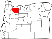 | |
| Hamlets | ||
| CDPs | ||
| Other unincorporated communities |
| |
| Footnotes | ‡This populated place also has portions in an adjacent county or counties | |