Gresham, Oregon
| Gresham, Oregon | |
|---|---|
| City | |
|
| |
 Gresham, Oregon Location in the United States | |
| Coordinates: 45°30′13″N 122°26′22″W / 45.50361°N 122.43944°WCoordinates: 45°30′13″N 122°26′22″W / 45.50361°N 122.43944°W | |
| Country | United States |
| State | Oregon |
| County | Multnomah |
| Incorporated | 1905 |
| Named for | Walter Q. Gresham |
| Government | |
| • Mayor | Shane Bemis (R) |
| Area[1] | |
| • City | 23.43 sq mi (60.68 km2) |
| • Land | 23.20 sq mi (60.09 km2) |
| • Water | 0.23 sq mi (0.60 km2) |
| Elevation | 325[2] ft (91.7 m) |
| Population (2010)[3] | |
| • City | 105,594 |
| • Estimate (2013[4]) | 109,397 |
| • Rank | US: 254th |
| • Density | 4,551.5/sq mi (1,757.3/km2) |
| • Metro | 2,314,554 |
| Demonym(s) | Greshamite[5] |
| Time zone | Pacific (UTC-8) |
| • Summer (DST) | Pacific (UTC-7) |
| ZIP codes | 97030, 97080, 97233 |
| Area code(s) | 503 and 971 |
| FIPS code | 41-31250 |
| GNIS feature ID | 1121424[6] |
| Website | www.greshamoregon.gov |
Gresham /ˈɡrɛʃəm/ is a city located in Multnomah County, Oregon, United States, immediately east of Portland. Though it began as a settlement in the mid-1800s, it was not officially incorporated as a city until 1905, by which it was named after the American Civil War general, and Postmaster General, Walter Quinton Gresham.
The city's early economy was sustained largely by farming, and by the mid-20th century, experienced a population boom, growing from four-thousand residents to over ten-thousand between 1960 and 1970. The population was 105,594 at the 2010 census, making Gresham the fourth largest city in Oregon.
History

The area now known as Gresham was first settled in 1851 by the brothers Jackson and James Powell, who claimed land under the Donation Land Claim Act of 1850. They were soon joined by other pioneer families, and the area came to be known as Powell's Valley.[7] In 1884, a local merchant petitioned the United States Postal Service to get a post office in his store and offered to name it after the Postmaster General Walter Q. Gresham if his request was granted. At the same time, other members of the community secured a post office called "Campground," another name for the area referencing the religious camp meeting ground located there and the valley's usefulness as a stop-off for travelers on their way to Portland. Once the Postal Service realized their mistake, they revoked the Campground post office.[8][9]
Gresham was incorporated in 1905, the year of the Lewis and Clark Centennial Exposition.[7] Its population at the time was 365.[7] Lewis Shattuck, son of a pioneer family, was the first mayor.[10] The town's economy was fueled largely by farming, including berries, grapes, and vegetables.[7] At the time, trains ran between Gresham and Portland on an hourly basis.[7] Gresham's early settlers would go on to form the outlying communities of Boring, Sandy, Fairview, and Estacada.[7]
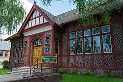
Gresham's city library, which began as a small book collection in the town general store, was officially established as the Gresham Branch Public Library in 1913 with a grant from the Andrew Carnegie library fund.[11][12]
Gresham General Hospital opened in 1959 in downtown Gresham. In 1984, the hospital moved to Stark Street and became Mount Hood Medical Center.[13][14]
Geography
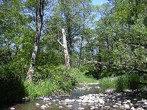
According to the United States Census Bureau, the city has a total area of 23.43 square miles (60.68 km2), of which, 23.20 square miles (60.09 km2) is land and 0.23 square miles (0.60 km2) is water.[1] The total area includes parts of Fairview Creek and Johnson Creek.
Topography
Gresham is located twelve miles from downtown Portland; the dividing line between Portland and Gresham's city limits is at SE 162nd Street.[15] As with Portland, Gresham's north and south borders are divided along Burnside Street, which becomes the Mount Hood Highway in east Gresham. The city is located roughly seventy miles east of the Oregon Coast.
Though much of Gresham is relatively flat, Northeast Gresham is hilly, particularly where the city meets Troutdale toward the Columbia River.[16] Its elevation is 325 feet (91.7 meters).[2] Johnson Creek, which begins at the foothills of the Cascade Mountains, runs westward through Gresham, with 23 percent of the creek's watershed running through the city.
Climate
| Climate data for Gresham, OR | |||||||||||||
|---|---|---|---|---|---|---|---|---|---|---|---|---|---|
| Month | Jan | Feb | Mar | Apr | May | Jun | Jul | Aug | Sep | Oct | Nov | Dec | Year |
| Average high °F (°C) | 46 (8) |
51 (11) |
56 (13) |
62 (17) |
69 (21) |
75 (24) |
82 (28) |
82 (28) |
77 (25) |
65 (18) |
53 (12) |
46 (8) |
63.7 (17.8) |
| Average low °F (°C) | 34 (1) |
36 (2) |
39 (4) |
42 (6) |
47 (8) |
52 (11) |
55 (13) |
55 (13) |
51 (11) |
44 (7) |
40 (4) |
35 (2) |
44.2 (6.8) |
| Average precipitation inches (mm) | 6.09 (154.7) |
5.16 (131.1) |
4.40 (111.8) |
3.65 (92.7) |
2.83 (71.9) |
2.20 (55.9) |
0.94 (23.9) |
1.10 (27.9) |
2.00 (50.8) |
3.34 (84.8) |
6.53 (165.9) |
6.61 (167.9) |
44.85 (1,139.2) |
| Source: [17] | |||||||||||||
Demographics
| Historical population | |||
|---|---|---|---|
| Census | Pop. | %± | |
| 1910 | 510 | — | |
| 1920 | 1,103 | 116.3% | |
| 1930 | 1,635 | 48.2% | |
| 1940 | 1,951 | 19.3% | |
| 1950 | 3,049 | 56.3% | |
| 1960 | 3,944 | 29.4% | |
| 1970 | 10,030 | 154.3% | |
| 1980 | 33,005 | 229.1% | |
| 1990 | 68,235 | 106.7% | |
| 2000 | 90,205 | 32.2% | |
| 2010 | 105,594 | 17.1% | |
| Est. 2015 | 110,553 | [18] | 4.7% |
| Sources: 2013 Estimate[20] | |||

As of 2000 the median income for a household in the city was $43,442, and the mean income for a family was $51,126. Males had a median income of $37,701 versus $27,744 for females. The per capita income for the city was $19,588. About 8.4% of families and 12.5% of the population were below the poverty line, including 17.2% of those under the age of 18 and 6.7% of those 65 and older.
- 2005-2007 American Community Survey Estimates
- 83.9% - White (71.1 non-Hispanic White)
- 18.3% - Hispanic or Latino (of any race)
- 5.1% - Asian
- 5.1% - Some other race
- 4.7% - American Indian or Alaska Native
- 3.7% - African American or Black
- 0.3% - Native Hawaiian and Other Pacific Islander
2010 census
As of the census[3] of 2010, there were 105,594 people, 38,704 households, and 25,835 families residing in the city. The population density was 4,551.5 inhabitants per square mile (1,757.3/km2). There were 41,015 housing units at an average density of 1,767.9 per square mile (682.6/km2). The racial makeup of the city was 76.0% White, 3.5% African American, 1.3% Native American, 4.3% Asian, 0.7% Pacific Islander, 9.8% from other races, and 4.5% from two or more races. Hispanic or Latino of any race were 18.9% of the population.
There were 38,704 households of which 36.9% had children under the age of 18 living with them, 46.6% were married couples living together, 14.3% had a female householder with no husband present, 5.9% had a male householder with no wife present, and 33.2% were non-families. 25.2% of all households were made up of individuals and 8.8% had someone living alone who was 65 years of age or older. The average household size was 2.69 and the average family size was 3.22.
The median age in the city was 33.6 years. 26.4% of residents were under the age of 18; 10.2% were between the ages of 18 and 24; 28.1% were from 25 to 44; 24.5% were from 45 to 64; and 10.7% were 65 years of age or older. The gender makeup of the city was 49.0% male and 51.0% female.
Government
The City of Gresham operates under the council-manager form of government. The mayor and city council are elected to be the legislative and policy-making body for the city.
The council appoints a city manager who is responsible for the daily operations of the city.[22] The city manager of Gresham is Erik Kvarsten, was appointed to the position on August 1, 2004.
The city council consists of the mayor and six councilors, all of whom serve four-year terms. Elections are held in November of even-numbered years. In elections in years divisible by four, (e.g. 2000, 2004, 2008), three councilors are elected. In elections in years not divisible by four, (e.g. 1998, 2002, 2006), the other three councilors and the mayor are elected.
Education
Gresham is served by three school districts: Centennial, Gresham-Barlow, and Reynolds. High schools include Gresham High School,Barlow High School, Centennial High School, and Reynolds High School. Private schools include Portland Adventist Elementary School, Eastside Christian School, and Morningstar Montessori school.
Mount Hood Community College is also located in Gresham, and is the only college located in the city limits. It offers associate degrees, as well as Bachelor's programs through a partnership with Eastern Oregon University. According to the US Census, 27.16% of the Gresham residents had a Bachelor's degree, while 9.93% had earned a master's degree or above.[2]
Parks and recreation

There are numerous parks in Gresham: Main City Park, located near downtown Gresham. Other parks include East Gresham Park, Red Sunset Park, and Clatsop Butte Park, an upland butte located south of Powell Butte, which runs between Portland and Gresham. Other public points of interest are the Gresham Pioneer Cemetery, established in 1859, and the Plaza del Sol.
Historic sites
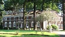
There are several National Register of Historic Places sites located in Gresham. The Louise Albertina Kerr Home, formerly a hospital and residence hall, is located in west Gresham, and serves as a social services facility. Other sites include: the Jacob Zimmerman House, a farmhouse built by German-American settlers in 1874; the Hamlin–Johnson House, a farmhouse built in 1888; the Emanuel and Christina Anderson House and William Gedamke House, both Victorian Queen Anne homes built circa 1900; the Gresham Carnegie Library, built in 1913; the Dr. Herbert H. Hughes House, built in 1922; the Charles and Fae Olson House, a modernist home built in 1946; and the David and Marianne Ott House, a ranch home built in 1952.[23]
Transportation
Highways
Gresham is accessed from the west via Interstate 84 and U.S. Route 26, from the east.
Mass transit
Gresham is serviced by TriMet's bus system and the MAX Light Rail Blue Line, which includes the following MAX stations:
- East 162nd Avenue
- East 172nd Avenue
- East 181st Avenue
- Rockwood/East 188th Avenue (serving the Rockwood neighborhood)
- Ruby Junction/East 197th Avenue
- Civic Drive (opened on December 1, 2010)
- Gresham City Hall
- Gresham Central Transit Center
- Cleveland Avenue (Blue Line's eastern terminus)
Gresham is also served by the fareless Sandy Area Metro shuttle bus to Sandy, Oregon.
Bicycle/pedestrian trails
- Springwater Corridor
- 40 Mile Loop
- Gresham–Fairview Trail
- Gresham Butte Saddle Trail
- Kelly Creek Greenway Trail
- Nadaka Loop Trail
Sister cities
Gresham has sister cities in other countries. They are:
References
- 1 2 "US Gazetteer files 2010". United States Census Bureau. Retrieved December 21, 2012.
- 1 2 3 "Analysis of Gresham City, Oregon". City Melt. Retrieved April 16, 2016.
- 1 2 "American FactFinder". United States Census Bureau. Retrieved December 21, 2012.
- ↑ "Population Estimates". United States Census Bureau. Retrieved June 15, 2014.
- ↑ "Who are you: The quest to name ourselves". Portland Tribune. Retrieved May 19, 2016.
- ↑ "US Board on Geographic Names". United States Geological Survey. October 25, 2007. Retrieved January 31, 2008.
- 1 2 3 4 5 6 "Gresham". PDX History. Retrieved April 18, 2016.
- ↑ "Gresham". Online Highways Home. Retrieved November 5, 2015.
- ↑ Chilton, W.R. (1993). Gresham: Stories of Our Past: Campground to City.
- ↑ Hoff 1910, p. 156.
- ↑ Endicott, Anne (July 6, 2012). "Telling the story of where we call home". Gresham Outlook. Retrieved December 3, 2012.
- ↑ Hottle, Molly (April 12, 2012). "Gresham Focus: Tour of buildings becomes a living history lesson". Oregon Live. Retrieved April 18, 2016.
- ↑ Reed, Watford (April 3, 1983). "Contract awarded for Gresham hospital project". The Oregonian. p. B1.
- ↑ Jeffries, Pat (October 26, 1984). "Move is quite an operation". The Oregonian. p. D17.
- ↑ "Portland, Oregon City Limits and Urban Services Boundary". City of Portland. April 7, 2015. Retrieved April 17, 2016.
- ↑ "City of Gresham, OR". TopoQuest. Retrieved April 9, 2016.
- ↑ "Average Weather for Gresham, OR - Temperature and Precipitation". Weather.com. Retrieved January 22, 2011.
- ↑ "Annual Estimates of the Resident Population for Incorporated Places: April 1, 2010 to July 1, 2015". Retrieved July 2, 2016.
- ↑ United States Census Bureau. "Census of Population and Housing". Retrieved September 19, 2013.
- ↑ "Annual Estimates of the Resident Population: April 1, 2010 to July 1, 2013". Retrieved June 15, 2014.
- ↑ U.S. Decennial Census. U.S. Census Bureau.
- ↑ "Governance and Management". City of Gresham. Retrieved November 5, 2015.
- ↑ "National Register of Historic Places" (PDF). Oregon.gov. June 6, 2011. Retrieved April 9, 2016.
Bibliography
- Hoff, O.P (1910). Biennial Report. Report of Bureau Labor Statistics. 4.
External links
| Wikivoyage has a travel guide for Gresham. |
Municipalities and communities of Multnomah County, Oregon, United States | ||
|---|---|---|
| Cities |  | |
| Unincorporated communities | ||
| Footnotes | ‡This populated place also has portions in an adjacent county or counties | |
Salem (capital) | |||||||||||||||
| Topics | |||||||||||||||
| Society | |||||||||||||||
| Regions |
| ||||||||||||||
| Metro areas | |||||||||||||||
| Largest cities |
| ||||||||||||||
| Counties | |||||||||||||||