Roseburg, Oregon
| Roseburg, Oregon | |
|---|---|
| City | |
 | |
| Motto: "Timber Capital of the Nation" | |
 Location within Douglas County and Oregon | |
| Coordinates: 43°13′5″N 123°21′22″W / 43.21806°N 123.35611°WCoordinates: 43°13′5″N 123°21′22″W / 43.21806°N 123.35611°W | |
| Country | United States |
| State | Oregon |
| County | Douglas |
| Incorporated | 1872 |
| Government | |
| • Mayor | Larry Rich |
| Area[1] | |
| • Total | 10.20 sq mi (26.42 km2) |
| • Land | 10.01 sq mi (25.93 km2) |
| • Water | 0.19 sq mi (0.49 km2) |
| Elevation | 528 ft (161 m) |
| Population (2010)[2] | |
| • Total | 21,181 |
| • Estimate (2013)[3] | 21,968 |
| • Density | 2,100/sq mi (800/km2) |
| Time zone | Pacific (UTC-8) |
| • Summer (DST) | Pacific (UTC-7) |
| ZIP code | 97470, 97471 |
| Area code | 541 |
| FIPS code | 41-63650 [4] |
| GNIS feature ID | 1126298 [5] |
| Website |
cityofroseburg |
Roseburg, at one time calling itself the timber capital of the nation, is a city in the U.S. state of Oregon.[6] It is located in the Umpqua River Valley in southern Oregon and is the county seat and most populous city of Douglas County. Founded 165 years ago, in 1851, the population was 21,181 at the 2010 census, making it the principal city of the Roseburg, Oregon Micropolitan Statistical Area. The community developed along both sides of the South Umpqua River and is traversed by Interstate 5. Traditionally a lumber industry town, Roseburg is the home of Roseburg Forest Products.
History
The city was named for settler Aaron Rose, who established a homestead within the current city limits on September 23, 1851.[7] Rose was born in 1813 in Ulster County, New York. In 1851, he came to Oregon from Coldwater, Michigan, where he had lived since 1837.[7]
Rose constructed the first building in what would become Roseburg, a rough structure made of poles and clapboards with a front room about 16 or 18 feet square; it was used as a grocery store, backed by a dining room and kitchen.[8] Originally, guests could use the floor of the front room to spread their beds or were able to sleep out of doors under nearby oak trees.[8] His first structure served as a roadside inn and tavern for many years. Rose built a proper hotel in 1853. He died in 1899.[7]
Roseburg was first known as Deer Creek because it was at the confluence of Deer Creek and the South Umpqua River.[7] In 1854, voters chose Roseburg as the county seat over rival town Winchester. Rose donated 3 acres (1.2 ha) of land and $1,000 for the building of the county courthouse, and the important buildings of Winchester were moved to Roseburg before 1860.[7]
Deer Creek post office was established in 1852, and the name changed to "Roseburgh" in 1857. The spelling was changed to "Roseburg" in 1894.[7] Roseburg was incorporated by the Oregon Legislative Assembly on October 3, 1872.[9]
Timber Capital of the Nation
The fortunes of Roseburg grew with the lumber industry. In 1937, Roseburg Lumber opened. Founded by Kenneth Ford, the company became the major employer in the community. Other major employers, including Weyerhaeuser, Champion and Sun Studs also developed and grew during this time. By the 1970s Roseburg branded itself as the Timber Capital of the Nation.
Roseburg Blast
On August 7, 1959, at approximately 1:00 a.m., the Gerretsen Building Supply Company caught fire. Firefighters soon arrived at the building, located near Oak and Pine street, to extinguish the fire. Earlier in the evening, a truck driver for the Pacific Powder Company, George Rutherford, had parked his explosives truck in front of the building, which was not noticed. The truck exploded at around 1:14 a.m., destroying buildings in an eight-block radius and severely damaging 30 more blocks.[10]
The truck was loaded with two tons of dynamite and four-and-a-half tons of the blasting agent nitro carbo nitrate. Rutherford had parked the truck after arranging his delivery for the following morning, despite warnings given to the Pacific Powder Company two days earlier not to leave such trucks unattended or park them in "congested areas". A police officer named Donald De Sues and the Chief of Police were on site and managed to evacuate citizens from the area of the truck before the explosion. Donald De Sues and the Chief of Police were recognized as heroes that day and were both killed in the blast.[11] A total of Fourteen people died in the blast and fire, and 125 were injured. Damage was estimated at 10 to 12 million dollars; the powder company was eventually made to pay $1.2 million in civil damages, but was acquitted of criminal wrongdoing.[10]
Roseburg's downtown was rebuilt, primarily by businesses using money collected from insurance claims. The city built a new bridge over the South Umpqua River on parcels affected by the disaster.[10] Since the incident, it is commonly referred to as the "Roseburg Blast" or simply "The Blast". In 2005, SOPTV produced a documentary examining the Blast and the experiences of those who were involved or witnessed it, entitled The Roseburg Blast: A Catastrophe and Its Heroes.[12]
Mass shooting
On October 1, 2015, students at Umpqua Community College near Roseburg were attacked by a 26-year-old gunman, who killed nine people (eight students and an assistant professor) and injured nine others. The gunman, a student at the school, committed suicide following a gun battle with police. This was the second school shooting in the Roseburg area, the other being a 2006 shooting at Roseburg High School. On October 9, President Barack Obama privately visited families of victims of the shooting.
Geography
According to the United States Census Bureau, the city has a total area of 10.20 square miles (26.42 km2), of which 10.01 square miles (25.93 km2) is land and 0.19 square miles (0.49 km2) is water.[1]
Roseburg's elevation is approximately 500 feet (150 m). Its highest point is Mount Nebo, a 1,200-foot (370 m) hill to the west of Interstate 5. Through the 1980s, it was known for its band of 10-20 feral angora goats. Residents said they could predict the weather by watching where the goats were on the mountain; if they were high, the weather would be good. If rain was pending, the goats moved to lower levels. Because the goats wandered across the freeway for grazing, they were a risk to traffic. In the 1980s, they were rounded up and placed for adoption.[13]
Roseburg is located near the confluence of the north and south forks of the Umpqua River and the borders of the Umpqua National Forest.
Climate
Roseburg has a Mediterranean climate (Köppen Csb) with cool, rainy winters and very warm, dry summers. December, with a mean temperature of 42.5 °F or 5.8 °C, is usually the coldest month, and July, with a mean temperature of 71.5 °F or 21.9 °C, is the warmest. In a typical year, there are 27 days where the temperature reaches or exceeds 90 °F or 32.2 °C, and two days with a temperature of or above 100 °F or 37.8 °C. Conversely, the temperature drops to 32 °F (0 °C) or below 28 times per annum.[14] The record high temperature is 109 °F (42.8 °C), set on July 20, 1946, and the record low temperature is −1 °F (−18.3 °C), set on January 22, 1962.[14] No other day has fallen to or below 0 °F or −17.8 °C, and by the 1981 to 2010 average only 28 mornings fall below freezing.
In the summer, the area has little or no precipitation and plentiful sunshine — on average, 73.5 percent of days in July, August and September are at least partly sunny.[14][15] On the other hand, the majority of winter days are overcast[16] and rainy — during this period, rainfalls of 8 inches or 200 millimetres per month are not uncommon, with as much as 15.74 inches or 399.8 millimetres during the record wet month of December 1955. Roseburg averages 30.7 inches or 779.8 millimetres of rain per year, more than half of which falls between November and January. The wettest “rain year” has been from July 1955 to June 1956 with 50.29 inches (1,277.4 mm) and the driest from July 2000 to June 2001 with only 18.43 inches (468.1 mm).
Light dustings of snow can sometimes be seen, but accumulations are rare. The most snowfall in a month is 23.4 inches (0.59 m) in January 1950, but no other month has had even 8 inches or 0.20 metres.
| Climate data for Roseburg, Oregon (Airport), 1981–2010 normals | |||||||||||||
|---|---|---|---|---|---|---|---|---|---|---|---|---|---|
| Month | Jan | Feb | Mar | Apr | May | Jun | Jul | Aug | Sep | Oct | Nov | Dec | Year |
| Record high °F (°C) | 70 (21) |
79 (26) |
83 (28) |
92 (33) |
105 (41) |
104 (40) |
109 (43) |
107 (42) |
104 (40) |
96 (36) |
76 (24) |
70 (21) |
109 (43) |
| Average high °F (°C) | 49.8 (9.9) |
53.4 (11.9) |
57.7 (14.3) |
62.5 (16.9) |
69.5 (20.8) |
76.2 (24.6) |
85.9 (29.9) |
85.3 (29.6) |
79.7 (26.5) |
65.8 (18.8) |
53.8 (12.1) |
48.1 (8.9) |
65.64 (18.68) |
| Daily mean °F (°C) | 43.4 (6.3) |
45.2 (7.3) |
48.2 (9) |
51.9 (11.1) |
58.3 (14.6) |
64.2 (17.9) |
71.4 (21.9) |
70.8 (21.6) |
65.6 (18.7) |
55.4 (13) |
47.2 (8.4) |
42.4 (5.8) |
55.33 (12.97) |
| Average low °F (°C) | 37.1 (2.8) |
37.0 (2.8) |
38.7 (3.7) |
41.3 (5.2) |
47.0 (8.3) |
52.2 (11.2) |
57.0 (13.9) |
56.4 (13.6) |
51.4 (10.8) |
44.9 (7.2) |
40.7 (4.8) |
36.8 (2.7) |
45.04 (7.25) |
| Record low °F (°C) | −1 (−18) |
13 (−11) |
19 (−7) |
25 (−4) |
26 (−3) |
34 (1) |
39 (4) |
41 (5) |
32 (0) |
21 (−6) |
15 (−9) |
5 (−15) |
−1 (−18) |
| Average precipitation inches (mm) | 4.92 (125) |
2.62 (66.5) |
3.00 (76.2) |
2.45 (62.2) |
2.05 (52.1) |
0.75 (19) |
0.11 (2.8) |
0.20 (5.1) |
0.82 (20.8) |
2.10 (53.3) |
4.66 (118.4) |
6.99 (177.5) |
30.67 (779) |
| Average precipitation days (≥ 0.01 in) | 18.8 | 15.0 | 16.6 | 15.1 | 10.1 | 6.2 | 1.1 | 1.6 | 4.4 | 11.1 | 17.4 | 20.6 | 138 |
| Source: NOAA [17] | |||||||||||||
Demographics
| Historical population | |||
|---|---|---|---|
| Census | Pop. | %± | |
| 1860 | 835 | — | |
| 1870 | 600 | −28.1% | |
| 1880 | 822 | 37.0% | |
| 1890 | 1,472 | 79.1% | |
| 1900 | 1,690 | 14.8% | |
| 1910 | 4,738 | 180.4% | |
| 1920 | 4,258 | −10.1% | |
| 1930 | 4,362 | 2.4% | |
| 1940 | 4,924 | 12.9% | |
| 1950 | 8,390 | 70.4% | |
| 1960 | 11,467 | 36.7% | |
| 1970 | 14,461 | 26.1% | |
| 1980 | 16,644 | 15.1% | |
| 1990 | 17,032 | 2.3% | |
| 2000 | 20,017 | 17.5% | |
| 2010 | 21,181 | 5.8% | |
| Est. 2015 | 22,114 | [18] | 4.4% |
| Source: United States Census Bureau[19] 2013 Estimate[3] | |||
2010 census
As of the census of 2010, there were 21,181 people, 9,081 households, and 5,177 families residing in the city. The population density was 2,116.0 inhabitants per square mile (817.0/km2). There were 9,732 housing units at an average density of 972.2 per square mile (375.4/km2). The racial makeup of the city was 91% White, 0.5% African American, 1.7% Native American, 1.6% Asian, 0.3% Pacific Islander, 1.4% from other races, and 3.5% from two or more races. Hispanic or Latino of any race were 5.5% of the population.
There were 9,081 households of which 27.0% had children under the age of 18 living with them, 39.2% were married couples living together, 13.2% had a female householder with no husband present, 4.6% had a male householder with no wife present, and 43.0% were non-families. 35.5% of all households were made up of individuals and 16.8% had someone living alone who was 65 years of age or older. The average household size was 2.23 and the average family size was 2.84.
The median age in the city was 41.1 years. 21.7% of residents were under the age of 18; 9.1% were between the ages of 18 and 24; 23.8% were from 25 to 44; 26.2% were from 45 to 64; and 19.1% were 65 years of age or older. The gender makeup of the city was 48.0% male and 52.0% female.
2000 census
As of the census[4] of 2000, there were 20,017 people, 8,237 households, and 5,098 families residing in the city. The population density was 2,171.1 people per square mile (838.2/km²). There were 8,838 housing units at an average density of 958.6 per square mile (370.1/km²). The racial makeup of the city was 93.56% White, 0.3% African American, 1.3% Native American, 0.99% Asian, 0.1% Pacific Islander, 1.26% from other races, and 2.48% from two or more races. Hispanic or Latino of any race were 3.73% of the population.
There were 8,237 households out of which 28.9% had children under the age of 18 living with them, 46.2% were married couples living together, 11.9% had a female householder with no husband present, and 38.1% were non-families. 31.6% of all households were made up of individuals and 13.9% had someone living alone who was 65 years of age or older. The average household size was 2.32 and the average family size was 2.88.
In the city the population was spread out with 23.2% under the age of 18, 8.9% from 18 to 24, 26.5% from 25 to 44, 22.4% from 45 to 64, and 18.9% who were 65 years of age or older. The median age was 39 years. For every 100 females there were 93.7 males. For every 100 females age 18 and over, there were 91.5 males.
The median income for a household in the city was $31,250, and the median income for a family was $40,172. Males had a median income of $32,624 versus $25,707 for females. The per capita income for the city was $17,082. About 11.0% of families and 15.1% of the population were below the poverty line, including 18.9% of those under age 18 and 9.2% of those age 65 or over.
Education
.jpg)
Primary and secondary public education in Roseburg are provided by the Roseburg School District. Umpqua Community College is the city's two-year college.
Economy
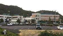
The unemployment rate in Roseburg is about 12 percent.[21] During the Great Recession of 2009, the unemployment rate peaked at 16.5% before falling.[22] The largest employer in the town is Roseburg Forest Products.[23] With 1,139 employees, Mercy Medical Center is the second largest employer in Roseburg.[24]
Media
Newspapers
There are three newspapers serving Roseburg. The News-Review is published six days per week and is based in Roseburg. The Roseburg Beacon is published weekly and serves Roseburg.[25] The Douglas County News is published weekly and is based in the nearby town of Sutherlin.
Radio
AM
FM
- KMPQ 88.1 NPR Variety
- KEAR 88.5 Family Radio – Religious
- KLOV 89.3 K-Love – Contemporary Christian
- KAWZ 90.7 CSN – Religious
- KSRS 91.5 JPR Classics and News
- KSMF 91.9 JPR Rhythm and News
- KDOV 92.7 Religious
- KCNA-FM 98.3 Classic Hits
- KSKR-FM 101.1 Jelli – Top 40
- KZEL-FM 102.1 Classic Rock
- KRSB-FM 103.1 Country
- KROG 103.7 Modern Rock
- KKMX 104.5 Sam FM – Adult Hits
- KYTT 105.5 Contemporary Christian
- KLLF-LP 106.7 Religious
Television
| Channel | Callsign | Network | Notes |
| 18 (36.1) | KTVC | 3ABN | Satellite of KBLN-TV, Grants Pass |
| 19 (4.1) | KPIC | CBS | Satellite of KVAL-TV, Eugene |
| 41 | K41JQ | NBC | Repeater of KOBI, Medford |
| 45 (46.1) | KTCW | NBC | Satellite of KMTR, Eugene |
| 46 | K46KS-D | ABC | Repeater of KEZI, Eugene |
| 47 | K47HT | 3ABN | Repeater of KBLN-TV, Grants Pass |
| 51 | K51GJ-D | PBS/OPB | Repeater of KEPB, Eugene |
Transportation
Airports
There are two public airports, Marion E. Carl Memorial Field at the north end of town and George Felt Airport to the west.
Buses and railroads
The city hosts a Greyhound bus station with connecting service to Amtrak passenger rail service. The Central Oregon and Pacific Railroad freight railway runs through Roseburg.
Roseburg and surrounding communities are served by U-Trans (formerly Umpqua Transit), a local bus service.[26]
Roads
Oregon Route 99 runs through downtown Roseburg as the main north-south arterial. Interstate 5 runs along the west side of the city, across the South Umpqua River from downtown.
Oregon Route 138 runs northwest from Roseburg to Elkton, Oregon, and generally east from Roseburg to its terminus at a junction with U.S. Route 97, just east of Diamond Lake and Crater Lake.
Notable people
- Art Alexakis – lead singer of Everclear
- Mike Allred – comic book artist
- Nasim Ashraf – PCB Chairman and Commissioner of NCHD
- Tim Blixseth – real estate developer, songwriter
- Jamie Burke – baseball player
- Troy Calhoun – head coach of the United States Air Force Academy football team
- Wes DeMott - international bestselling author
- Marion Eugene Carl – Marine Corps general and flying ace
- Guy Cordon – U.S. Senator, Douglas County District Attorney, lawyer
- Jeremy Guthrie – professional baseball pitcher
- Tyler Hentschel – lead singer of Insomniac Folklore
- David Hume Kennerly – presidential photographer for Gerald Ford, Pulitzer Prize winner
- John Kitzhaber – Oregon governor, 1995–2003, 2011–2015
- William W. Knight – publisher of The Oregon Journal
- Joseph Lane – general and early governor of Oregon, his home is now a museum in downtown Roseburg
- Matthew Lessner – director and screenwriter
- Shelley Plimpton – former actress and mother of actress Martha Plimpton
- Barry Serafin – television journalist
- Alek Skarlatos – Oregon Army National Guardsman, recipient of the Knights of the Legion of Honour
- Craig Tanner – film director, producer, editor
- Chris Thompson (swimmer) - 2000 Olympic Bronze Medalist - 1500 Meter Freestyle
- ZZ Ward – musician, singer, songwriter
Sister cities
Roseburg has three sister cities:[27]
 Aranda de Duero, Castile and León, Spain
 Shōbu, Saitama (was merged into Kuki, Saitama), Japan
 Kermanshah, Iran
See also
References
- 1 2 "US Gazetteer files 2010". United States Census Bureau. Retrieved December 21, 2012.
- ↑ "American FactFinder". United States Census Bureau. Retrieved December 21, 2012.
- 1 2 "Population Estimates". United States Census Bureau. Retrieved October 2, 2014.
- 1 2 "American FactFinder". United States Census Bureau. Retrieved January 31, 2008.
- ↑ "US Board on Geographic Names". United States Geological Survey. October 25, 2007. Retrieved January 31, 2008.
- ↑ "Find a County". National Association of Counties. Retrieved June 7, 2011.
- 1 2 3 4 5 6 McArthur, Lewis A.; McArthur, Lewis L. (2003) [1928]. Oregon Geographic Names (7th ed.). Portland, Oregon: Oregon Historical Society Press. p. 723. ISBN 978-0875952772.
- 1 2 Riddle, George W. (1922). "Annual Address". Transactions of the Forty-Seventh Annual Reunion of the Oregon Pioneer Association June 19, 1919. Portland, OR: Chausse-Prudhomme Co. pp. 165–166.
- ↑ Baker, Frank C. (1891). "Special Laws". The Laws of Oregon, and the Resolutions and Memorials of the Sixteenth Regular Session of the Legislative Assembly Thereof. Salem, Oregon: State Printer: 888.
- 1 2 3 Binus, Joseph (2006). "Roseburg Blast Crater, 1959". The Oregon History Project. Retrieved October 6, 2006.
- ↑ Roseburg Newspaper and Police Department
- ↑ "History Minute: Roseburg Blast: A Catastrophe and Its Heroes". Southern Oregon Public Television (SOPTV). Retrieved October 6, 2006.
- ↑ "Mount Nebo Goats Placed for Adoption", Eugene Register-Guard, August 8, 1984, accessed October 6, 2015
- 1 2 3 "National Weather Service – NWS Medford". Nws.noaa.gov. July 21, 2006. Retrieved August 18, 2012.
- ↑ "ROSEBURG WB AP, OREGON USA Weather History and Climate Data". Worldclimate.com. Retrieved August 18, 2012.
- ↑ "Roseburg Douglas County Oregon average temperature, sunshine and precipitation data". Homefacts.com. Retrieved August 18, 2012.
- ↑ "NowData – NOAA Online Weather Data". National Oceanic and Atmospheric Administration. Retrieved December 15, 2011.
- ↑ "Annual Estimates of the Resident Population for Incorporated Places: April 1, 2010 to July 1, 2015". Retrieved July 2, 2016.
- ↑ Moffatt, Riley. Population History of Western U.S. Cities & Towns, 1850–1990. Lanham: Scarecrow, 1996, 215.
- ↑ United States Census Bureau. "Census of Population and Housing". Retrieved October 2, 2014.
- ↑ "Economy in Roseburg, Oregon". Sperling's Best Places. Retrieved May 26, 2014.
- ↑ Mimms, Cory (September 2010). "Job loss in Roseburg". Oregon Business. Retrieved May 26, 2014.
- ↑ "Roseburg gets an incubator". Oregon Business. January 2010. Retrieved August 18, 2012.
- ↑ "Douglas County Largest Employers" (PDF). Umpqua Economic Development Partnership.
- ↑ "Official website". Roseburg Beacon.
- ↑ "U-Trans".
- ↑ "Sister Cities". City of Roseburg. Retrieved August 18, 2012.
External links
| Wikivoyage has a travel guide for Roseburg. |
| Wikimedia Commons has media related to Roseburg, Oregon. |
- City of Roseburg (official website)
- Entry for Roseburg in the Oregon Blue Book
Municipalities and communities of Douglas County, Oregon, United States | ||
|---|---|---|
| Cities | 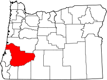 | |
| CDPs | ||
| Unincorporated communities | ||