Flaming Gorge Reservoir
| Flaming Gorge Reservoir | |
|---|---|
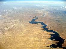
_23-9-2014_12-49-13.JPG) Flaming Gorge Reservoir in Utah | |
| Location | Sweetwater County, Wyoming / Daggett County, Utah, US |
| Coordinates | 41°09′41″N 109°33′04″W / 41.16139°N 109.55111°WCoordinates: 41°09′41″N 109°33′04″W / 41.16139°N 109.55111°W |
| Lake type | Hydroelectric reservoir |
| Primary inflows | Green River; Blacks Fork |
| Primary outflows | Green River |
| Basin countries | United States |
| Surface area | 42,020 acres (170 km2) |
| Water volume | 3,788,900 acre·ft (4.6735 km3) |
| Surface elevation | 6,040 ft (1841 m) |
| Settlements | Manila, Utah; Dutch John, Utah |
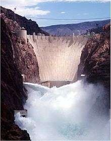
Flaming Gorge Reservoir is the largest reservoir in Wyoming, on the Green River, impounded behind the Flaming Gorge Dam. Construction on the dam began in 1958 and was completed in 1964. The reservoir stores 3,788,900 acre feet (4.6735×10⁹ m3) of water when measured at an elevation of 6,040 feet (1,840 m) above sea-level (maximum).
Location
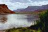
The reservoir is mainly in southwest Wyoming and partially in northeastern Utah. The northern tip of the reservoir is 10 miles (16 km) southeast of Green River, Wyoming, 14 mi (23 km) southwest of Rock Springs, Wyoming, and 43 miles (69 km) north of Vernal, Utah. The lake straddles the Utah-Wyoming border. The nearby town of Dutch John, Utah, was built to serve as a base camp during construction of the dam, and as an administrative site afterwards.
Geology
The foundation of the reservoir is a steep-sided narrow canyon composed of siliceous sandstone and hard quartzites inter-bedded with softer shales, siltstones, and argillites. About 1.5 miles (2.4 km) east of the dam, a road cut has revealed a fault scarp on the southbound side with about 9 feet (3 m) of slippage.
Recreation
Visitors enjoy hiking, boating, fishing, windsurfing, camping, backpacking, cross-country skiing, and snowmobiling within Flaming Gorge National Recreation Area, which is operated by Ashley National Forest. Camp sites can be found close to the dam and along Highway 191 for a fee, as well as free throughout the area. Campgrounds operated by the U.S. Forest Service close in the winter months, with the exception of Dripping Springs near Dutch John. There are also public camp sites at Buck Board and Lucerne Marinas, along Highway 530 on the west side of the reservoir. The many available fish species in the reservoir and surrounding lakes are Colorado River Cutthroat trout, Brown trout, Rainbow trout , Lake trout, Kokanee salmon, Smallmouth bass, Burbot and Common carp. The Green River is a popular spot for fishing, mainly below the dam. The river's ice cold water and beautiful structure make it a world class, world-renowned fly fishing stream.
See also
Further reading
- Webb, Roy (2012). Lost Canyons of the Green River: The Story before Flaming Gorge Dam. ISBN 978-1-60781-179-4.
External links
- Ashley National Forest: official Flaming Gorge National Recreation Area website
- Utah Division of Wildlife Resources: Flaming Gorge Reservoir
- "Report on Flaming Gorge Reservoir" (PDF). (108 KiB) from the Utah Division of Water Quality
- Flaming Gorge Fishing Info
- United States Bureau of Reclamation−USBR.gov: Flaming Gorge Dam Environmental Impact Statement
| Wikimedia Commons has media related to Flaming Gorge Reservoir. |

Colorado River system | |||||||||||||||
|---|---|---|---|---|---|---|---|---|---|---|---|---|---|---|---|
| Jurisdictions |
|     | |||||||||||||
| Canyons |
| ||||||||||||||
| Natural features |
| ||||||||||||||
| Tributaries | |||||||||||||||
| Engineering |
| ||||||||||||||
| Designated areas | |||||||||||||||
| Related topics | |||||||||||||||