Grand Lake (Colorado)
| Grand Lake | |
|---|---|
 looking east | |
| Location | Grand County, Colorado |
| Coordinates | 40°14′42″N 105°48′58″W / 40.24500°N 105.81611°WCoordinates: 40°14′42″N 105°48′58″W / 40.24500°N 105.81611°W |
| Lake type | Glacial Lake |
| Catchment area | Native inflows come from the Continental Divide through Rocky Mountain National Park. |
| Basin countries | United States |
| Max. length | 1.5 mi (2.4 km)[1] |
| Max. width | 1 mi (1.6 km)[1] |
| Surface area | 507 acres (205 ha)[2] |
| Max. depth | 265 ft (81 m)[2] |
| Water volume | 68,621 acre·ft (84,643,000 m3)[2] |
| Shore length1 | 4 mi (6.4 km) (approx)[3] |
| Surface elevation | 8,367 ft (2,550 m) |
| Settlements | Grand Lake, Colorado |
| 1 Shore length is not a well-defined measure. | |
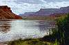
Grand Lake is Colorado's largest and deepest natural lake.[4] It is located in the headwaters of the Colorado River in Grand County, Colorado. On its north shore is located the historic and eponymous town of Grand Lake. The lake fills a glaciated valley that is dammed in part by glacial till from the Pinedale Glaciation, and is younger than about 12,000 years. Natural tributaries to the lake are the North Inlet and East Inlet, both of which flow out of Rocky Mountain National Park, which surrounds the lake on three sides: Grand Lake is located 1 mile from the Park's western entrance. Grand Lake was named Spirit Lake by the Ute Tribe because they believed the lake's cold waters to be the dwelling place of departed souls.
Colorado-Big Thompson Project
As part of the Colorado-Big Thompson Project, Grand Lake forms a continuous body of water with the man-made reservoir Shadow Mountain Lake, which under natural conditions then flows into another man-made reservoir, Lake Granby. The elevation of Grand Lake is maintained between 8,367 feet (2,550 meters) and 8,366 feet (2,549.8 meters). When the Colorado-Big Thompson (C-BT) project is diverting water to northeastern Colorado, water collected in Lake Granby can be pumped back into Shadow Mountain where it flows backward into Grand Lake, then under Rocky Mountain National Park and the Continental Divide via the Alva B. Adams Tunnel to the Big Thompson River on the eastern slope of the Rocky Mountains. From there, the water flows into the South Platte River and is used for agriculture, municipal, and industrial purposes. Diverted C-BT water provides hydroelectric power to five power stations on the eastern slope of the Colorado Rockies.
The C-BT is one of the first of many large-scale diversions of water from the Colorado River Basin between Colorado and the Gulf of California. Because the C-BT Project moves water from the Colorado Basin to the South Platte Basin, or, on a larger scale, from the Colorado River, which drains to the Gulf of California to the Mississippi River, which drains to the Gulf of Mexico, the project is considered a transbasin diversion.
References
- 1 2 "Grand Lake Winter Adventure Tour".
- 1 2 3 Lieberman, D.M. 2008. Physical, Chemical, and biological Attributes of Western and Eastern Slope Reservoir, Lake, and Flowing Water sites on the Colorado-Big Thompson Project 2005-2007: Lake Granby, Grand Lake, Shadow Mountain Reservoir, Horsetooth Reservoir, Carter Lake. Denver Colorado: Department of Interior, Bureau of Reclamation; 469p
- ↑ Grand County Government
- ↑ Pennak, R.W. 1955 Comparative Limnology of Eight Colorado Mountain Lakes. University of Colorado Studies, Series in Biology 2:1-71, Boulder, CO 1955
External links
| Wikimedia Commons has media related to Grand Lake, Colorado. |
- U.S. Bureau of Reclamation website on Colorado-Big Thompson Project
- Map of Grand Lake Village
- Grand Lake Area Events
- Grand County Water Information Network
- Town of Grand Lake Homepage
- Grand Lake Chamber Homepage
- Grand County Government Homepage
- Arapaho National Recreation Area website
- Colorado County Evolution by Don Stanwyck
- Colorado Historical Society
- Grand County Library District website
- Grand County Tourism Board website
- National Register of Historic Places listing for Grand County
- Rocky Mountain National Park website
Colorado River system | |||||||||||||||
|---|---|---|---|---|---|---|---|---|---|---|---|---|---|---|---|
| Jurisdictions |
|     | |||||||||||||
| Canyons |
| ||||||||||||||
| Natural features |
| ||||||||||||||
| Tributaries | |||||||||||||||
| Engineering |
| ||||||||||||||
| Designated areas | |||||||||||||||
| Related topics | |||||||||||||||