List of dams in the Colorado River system
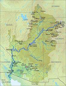
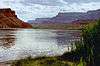
This is a list of dams on the Colorado River system of the southwestern United States and northwestern Mexico. The Colorado runs 1,450 mi (2,330 km) from the Rocky Mountains to the Gulf of California, draining parts of seven U.S. states and two Mexican states. The river system is one of the most heavily developed in the world, with fifteen dams on the main stem of the Colorado and hundreds more on tributaries. Collectively, dams in the Colorado River basin can hold four to five times the river's annual flow, generating hydroelectricity and supplying irrigation and municipal water for over 35 million people.
Dams on tributaries are listed if they are taller than 250 ft (76 m), store more than 50,000 acre·ft (62,000 dam3), or are otherwise historically notable. Tributary dams are organized into two lists; those in the Upper Basin, defined as the half of the Colorado River basin above Lee's Ferry, Arizona, and the Lower Basin. The Upper Basin include such tributary systems as the Green, Gunnison and San Juan. Tributaries in the Lower Basin include the Little Colorado, Virgin and Gila. A key tributary of the San Juan River, the Animas River, was severely affected by the EPA's accidental August 2015 Gold King Mine waste water spill.
Notes:
- Flood control: Temporary retention and quick release of flood flows
- Hydropower: Generation of electricity utilizing water flow through the hydraulic head provided by the dam and reservoir
- Irrigation: Provision and storage of water for agriculture
- Municipal: Provision and storage of water for residential, commercial and industrial uses
- Regulation: To control erratic inflows to provide either a stable flow downstream or to release water on demand to downstream users
Main stem
|

| Name | State | Owner | Purpose | Year completed |
Reservoir | Reservoir capacity |
Capacity (MW) |
Annual generation (MWh) |
Refs |
|---|---|---|---|---|---|---|---|---|---|
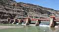
| Morelos Dam | IBWC | Irrigation | 1950 | N/A | N/A | N/A | N/A | [1] | |
| Laguna Diversion Dam | USBR | Diversion | 1905 | N/A | N/A | N/A | N/A | [2] | |
| Imperial Dam | USBR | Irrigation | 1938 | Imperial Reservoir | 160,000 acre.ft (197,400 dam3) |
N/A | N/A | [n 1][3] | |
| Palo Verde Dam | USBR | Diversion | 1958 | N/A | N/A | N/A | N/A | [4] | |
| Headgate Rock Dam | BIA | Irrigation | 1941 | Moovalya Lake | N/A | 19.5 | ? | [5][6] | |
| Parker Dam | USBR | Hydropower Irrigation Municipal |
1938 | Lake Havasu | 646,200 acre.ft (797,100 dam3) |
120 | 456,944 | [7] | |
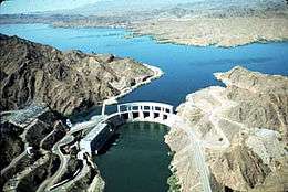
| Davis Dam | USBR | Hydropower Regulation |
1951 | Lake Mohave | 1,818,300 acre.ft (2,242,800 dam3) |
255 | 1,147,673 | [8][9] | |
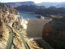
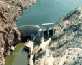
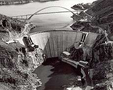
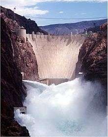
| Hoover Dam | USBR | Flood control Hydropower Irrigation Municipal Regulation |
1936 | Lake Mead | 28,945,000 acre.ft (35,702,400 dam3) |
2,079 | 3,806,935 | [10][11] | |
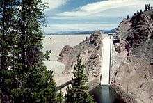
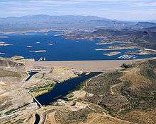
| Glen Canyon Dam | USBR | Hydropower Regulation |
1966 | Lake Powell | 26,214,900 acre.ft (32,334,900 dam3) |
1,296 | 3,454,847 | [12][13] | |
| Price-Stubb Dam | PCID[n 2] MCID[n 3] |
Irrigation | 1911 | N/A | N/A | N/A | N/A | [n 4][14] | |
| Grand Valley Diversion Dam | USBR | Irrigation | 1916 | N/A | N/A | 3 | 19,350 | [15] | |
| Windy Gap Dam | Northern Water | Irrigation Municipal |
1970 | Windy Gap Reservoir | 445 acre.ft (549 dam3) |
N/A | N/A | [16] | |
| Granby Dam | USBR | Irrigation Municipal |
1950 | Lake Granby | 539,800 acre.ft (665,800 dam3) |
N/A | N/A | [17] | |
| Shadow Mountain Dam | USBR | Irrigation Municipal |
1946 | Shadow Mountain Lake | 18,400 acre.ft (22,700 dam3) |
N/A | N/A | [18] | |
| Total | 58,343,045 acre.ft (71,963,595 dam3) |
3,772.5 | 8,885,749 | ||||||
Upper Basin
|


| Name | State | Stream | Owner | Purpose | Year completed |
Reservoir | Reservoir capacity |
Capacity (MW) |
Annual generation (MWh) |
Refs |
|---|---|---|---|---|---|---|---|---|---|---|
| Blue Mesa Dam | Gunnison | USBR | Flood control Hydropower Regulation |
1966 | Blue Mesa Reservoir | 940,700 acre.ft (1,160,300 dam3) |
86.4 | 203,412 | [19] | |
| Dillon Dam | Blue | Denver Water | Irrigation Municipal |
1963 | Dillon Reservoir | 257,304 acre.ft (317,373 dam3) |
1.8 | ? | [20][21] | |
| Flaming Gorge Dam | Green | USBR | Flood control Hydropower Regulation |
1964 | Flaming Gorge Reservoir | 3,788,700 acre.ft (4,673,200 dam3) |
153 | 344,369 | [22] | |
| Fontenelle Dam | Green | USBR | Flood control Irrigation |
1964 | Fontenelle Reservoir | 345,360 acre.ft (426,990 dam3) |
10 | 67,043 | [23] | |
| Green Mountain Dam | Blue | USBR | Hydropower Regulation |
1943 | Green Mountain Reservoir | 153,639 acre.ft (189,507 dam3) |
21.6 | 60,228 | [24][25] | |
| Joes Valley Dam | Seely Cr. | USBR | Irrigation Municipal |
1966 | Joes Valley Reservoir | 54,920 acre.ft (67,740 dam3) |
N/A | N/A | [26] | |
| McPhee Dam | Dolores | USBR | Flood control Irrigation |
1984 | McPhee Reservoir | 381,195 acre.ft (470,187 dam3) |
1.283 | 5,335 | [27][28] | |
| Morrow Point Dam | Gunnison | USBR | Hydropower | 1968 | Morrow Point Reservoir | 117,190 acre.ft (144,550 dam3) |
173.334 | 292,887 | [29][30] | |
| Navajo Dam | San Juan | USBR | Flood control Irrigation Municipal Regulation |
1962 | Navajo Lake | 1,708,600 acre.ft (2,107,500 dam3) |
32 | 215,000 | [n 5][31][32] | |
| Ridges Basin Dam | Offstream | USBR | Irrigation | 2007 | Lake Nighthorse | 120,000 acre.ft (148,000 dam3) |
N/A | N/A | [33] | |
| Ridgway Dam | Uncompahgre | USBR | Flood control Irrigation |
1987 | Ridgway Reservoir | 84,410 acre.ft (104,120 dam3) |
N/A | N/A | [34] | |
| Ruedi Dam | Fryingpan | USBR | Irrigation Municipal |
1968 | Ruedi Reservoir | 102,000 acre.ft (125,800 dam3) |
N/A | N/A | [35] | |
| Scofield Dam | Price | USBR | Irrigation Municipal |
1946 | Scofield Reservoir | 73,600 acre.ft (90,780 dam3) |
N/A | N/A | [36] | |
| Soldier Creek Dam | Strawberry | USBR | Irrigation Municipal |
1974 | Strawberry Reservoir | 1,127,610 acre.ft (1,390,860 dam3) |
N/A | N/A | [37] | |
| Starvation Dam | Strawberry | USBR | Irrigation | 1970 | Starvation Reservoir | 167,300 acre.ft (206,400 dam3) |
N/A | N/A | [38] | |
| Taylor Park Dam | Taylor | USBR | Irrigation | 1937 | Taylor Park Reservoir | 106,200 acre.ft (130,990 dam3) |
N/A | N/A | [39] | |
| Vallecito Dam | Los Pinos River | USBR | Irrigation | 1941 | Vallecito Reservoir | 129,700 acre.ft (160,000 dam3) |
N/A | N/A | [40] | |
| Vega Dam | Plateau Creek | USBR | Irrigation | 1959 | Vega Reservoir | 33,800 acre.ft (41,691 dam3) |
N/A | N/A | [41] | |
| Williams Fork Dam | Williams Fork | Denver Water | Irrigation Municipal |
1959 | Williams Fork Reservoir | 96,822 acre.ft (119,426 dam3) |
3.158 | ? | [42] | |
| Wolford Mountain Dam | Muddy Cr. | CRWCD[n 6] | Irrigation Municipal |
1996 | Wolford Mountain Reservoir | 66,000 acre.ft (81,400 dam3) |
N/A | N/A | [43] | |
| Total | 9,821,250 acre.ft (12,114,080 dam3) |
482.575 | 1,188,274 | |||||||
Lower Basin
|
| Name | State | Stream | Owner | Purpose | Year completed |
Reservoir | Reservoir capacity |
Capacity (MW) |
Annual generation (MWh) |
Refs |
|---|---|---|---|---|---|---|---|---|---|---|
| Alamo Dam | Bill Williams | USACE | Flood control | 1968 | Alamo Lake | 1,043,000 acre.ft (1,286,500 dam3) |
N/A | N/A | [44] | |
| Bartlett Dam | Verde | USBR | Flood control Irrigation |
1939 | Bartlett Lake | 176,186 acre.ft (217,318 dam3) |
N/A | N/A | [45] | |
| Coolidge Dam | Gila | BIA | Flood control Irrigation |
1930 | San Carlos Lake | 910,000 acre.ft (1,122,400 dam3) |
N/A | N/A | [46] | |
| Horse Mesa Dam | Salt | USBR | Hydropower Regulation |
1927 | Apache Lake | 245,138 acre.ft (302,367 dam3) |
129 | 126,900 | [n 7][48] | |
| Horseshoe Dam | Verde | USBR | Flood control Regulation |
1946 | Horseshoe Lake | 131,500 acre.ft (162,200 dam3) |
N/A | N/A | [49] | |
| Mormon Flat Dam | Salt | USBR | Hydropower Regulation |
1925 | Canyon Lake | 57,852 acre.ft (71,358 dam3) |
60 | 65,400 | [n 8][50] | |
| New Waddell Dam | Agua Fria | USBR | Irrigation Municipal |
1994 | Lake Pleasant | 1,108,600 acre.ft (1,367,409 dam3) |
45 | ? | [51] | |
| Painted Rock Dam | Gila | USACE | Flood control | 1960 | Painted Rock Reservoir | 2,491,700 acre.ft (3,073,400 dam3) |
N/A | N/A | [52] | |
| Sand Hollow Dam | Offstream | WCWCD[n 9] | Irrigation Municipal |
2002 | Sand Hollow Reservoir | 51,360 acre.ft (63,350 dam3) |
N/A | N/A | [52] | |
| Stewart Mountain Dam | Salt | USBR | Hydropower Regulation |
1930 | Saguaro Lake | 69,765 acre.ft (86,052 dam3) |
13 | 57,700 | [n 10][53] | |
| Theodore Roosevelt Dam | Salt | USBR | Flood control Hydropower Irrigation Municipal |
1911 | Theodore Roosevelt Lake | 2,910,200 acre.ft (3,589,600 dam3) |
36 | 123,900 | [n 11][54] | |
| Total | 9,195,301 acre.ft (11,342,000 dam3) |
283 | 373,900 | |||||||
Notes
- ↑ Reservoir capacity given is the original capacity in 1938 before siltation.
- ↑ Palisade County Irrigation District
- ↑ Mesa County Irrigation District
- ↑ Dam went out of operation in 1919 after the completion of the Grand Valley Diversion Dam upstream, but remains in place
- ↑ Annual power generation calculated from a power station hydraulic head of 381.6 ft (116.3 m) and average annual flow of 1,082 cu ft/s (30.6 m3/s) in the San Juan River below the dam, 1963–2012.
- ↑ Colorado River Water Conservation District
- ↑ Annual generation calculated from a hydraulic head of 255 ft (78 m) and an average Salt River flow of 962 cu ft/s (27.2 m3/s).[47]
- ↑ Annual generation calculated from a hydraulic head of 131.5 ft (40.1 m) and an average Salt River flow of 962 cu ft/s (27.2 m3/s).[47]
- ↑ Washington County Water Conservation District
- ↑ Annual generation calculated from a hydraulic head of 116 ft (35 m) and an average Salt River flow of 962 cu ft/s (27.2 m3/s).[47]
- ↑ Annual generation calculated from a hydraulic head of 249 ft (76 m) and an average Salt River flow of 962 cu ft/s (27.2 m3/s).[47]
References
- ↑ http://www.ibwc.state.gov/Water_Data/Colorado/Index.html
- ↑ http://www.usbr.gov/projects/Facility.jsp?fac_Name=Laguna+Diversion+Dam
- ↑ http://www.usbr.gov/projects/Facility.jsp?fac_Name=Imperial+Diversion+Dam&groupName=General
- ↑ http://www.usbr.gov/projects/Facility.jsp?fac_Name=Palo+Verde+Diversion+Dam
- ↑ http://www.waterrights.ca.gov/IID/IIDHearingData/LocalPublish/CRIT4.pdf
- ↑ http://www.usbr.gov/lc/region/g4000/hourly/HeadgateReport.pdf
- ↑ http://www.usbr.gov/projects/Facility.jsp?fac_Name=Parker+Dam
- ↑ http://www.usbr.gov/projects/Facility.jsp?fac_Name=Davis+Dam
- ↑ http://www.usbr.gov/projects/Powerplant.jsp?fac_Name=Davis%20Powerplant
- ↑ http://www.usbr.gov/projects/Facility.jsp?fac_Name=Hoover+Dam
- ↑ http://www.usbr.gov/projects/Powerplant.jsp?fac_Name=Hoover%20Powerplant
- ↑ http://www.usbr.gov/projects/Facility.jsp?fac_Name=Glen+Canyon+Dam&groupName=Overview
- ↑ http://www.usbr.gov/projects/Powerplant.jsp?fac_Name=Glen%20Canyon%20Powerplant
- ↑ http://www.usbr.gov/uc/wcao/envprog/pdfs/PriceStubbFP-ba.pdf
- ↑ http://www.usbr.gov/projects/Project.jsp?proj_Name=Grand+Valley+Project
- ↑ http://www.northernwater.org/WaterProjects/WindyGapProject.aspx
- ↑ http://www.usbr.gov/projects/Facility.jsp?fac_Name=Granby%20Dam
- ↑ http://www.usbr.gov/projects/Facility.jsp?fac_Name=Shadow+Mountain+Dam&groupName=Overview
- ↑ http://www.usbr.gov/projects/Facility.jsp?fac_Name=Blue%20Mesa%20Dam
- ↑ http://www.denverwater.org/recreation/dillon.html
- ↑ http://www.waterpowermagazine.com/features/featuresteely-dam-repair-work-at-dillion-spillway
- ↑ http://www.usbr.gov/projects/Facility.jsp?fac_Name=Flaming+Gorge+Dam&groupName=General
- ↑ http://www.usbr.gov/projects/Facility.jsp?fac_Name=Fontenelle%20Dam
- ↑ http://www.usbr.gov/projects/Facility.jsp?fac_Name=Green+Mountain+Dam&groupName=Overview
- ↑ http://www.usbr.gov/projects/Powerplant.jsp?fac_Name=Green%20Mountain%20Powerplant
- ↑ http://www.usbr.gov/projects/Facility.jsp?fac_Name=Joes+Valley+Dam&groupName=Overview
- ↑ http://www.usbr.gov/projects/Facility.jsp?fac_Name=McPhee+Dam
- ↑ http://www.usbr.gov/projects/Powerplant.jsp?fac_Name=McPhee%20Powerplant
- ↑ http://www.usbr.gov/projects/Facility.jsp?fac_Name=Morrow+Point+Dam
- ↑ http://www.usbr.gov/projects/Powerplant.jsp?fac_Name=Morrow%20Point%20Powerplant
- ↑ http://wdr.water.usgs.gov/wy2012/pdfs/09355500.2012.pdf
- ↑ http://www.usbr.gov/uc/rm/crsp/navajo/index.html
- ↑ http://www.usbr.gov/newsroom/newsrelease/detail.cfm?RecordID=19521
- ↑ http://www.usbr.gov/projects/Facility.jsp?fac_Name=Ridgway%20Dam
- ↑ http://www.usbr.gov/projects/Project.jsp?proj_Name=Fryingpan-Arkansas%20Project
- ↑ http://www.usbr.gov/projects/Facility.jsp?fac_Name=Scofield%20Dam
- ↑ http://www.usbr.gov/projects/Facility.jsp?fac_Name=Soldier+Creek+Dam&groupName=Overview
- ↑ http://www.usbr.gov/projects/Facility.jsp?fac_Name=Starvation+Dam
- ↑ http://www.usbr.gov/projects/Project.jsp?proj_Name=Uncompahgre%20Project
- ↑ http://www.usbr.gov/projects/Facility.jsp?fac_Name=Vallecito+Dam&groupName=Overview
- ↑ http://www.usbr.gov/projects/Facility.jsp?fac_Name=Vega+Dam&groupName=General
- ↑ http://www.denverwater.org/Recreation/WilliamsFork/
- ↑ http://www.crwcd.org/page_21
- ↑ http://www.azwater.gov/azdwr/StatewidePlanning/RuralPrograms/OutsideAMAs_PDFs_for_web/Upper_Colorado_River_Planning_Area/Bill_Williams_Watershed.pdf
- ↑ http://www.srpnet.com/water/dams/bartlett.aspx
- ↑ http://web.archive.org/web/20011031185425/http://www.usbr.gov/cdams/dams/coolidge.html
- 1 2 3 4 http://wdr.water.usgs.gov/wy2012/pdfs/09502000.2012.pdf
- ↑ http://www.srpnet.com/water/dams/horsemesa.aspx
- ↑ http://www.usbr.gov/projects/Facility.jsp?fac_Name=Horseshoe+Dam&groupName=Overview
- ↑ http://www.srpnet.com/water/dams/mormon.aspx
- ↑ http://www.usbr.gov/projects/Facility.jsp?fac_Name=New+Waddell+Dam&groupName=Overview
- 1 2 http://www.crrel.usace.army.mil/library/specialreports/SR99_06.pdf
- ↑ http://www.usbr.gov/projects/Facility.jsp?fac_Name=Stewart+Mountain+Dam
- ↑ http://www.usbr.gov/projects/Facility.jsp?fac_Name=Theodore+Roosevelt+Dam&groupName=Overview
Colorado River system | |||||||||||||||
|---|---|---|---|---|---|---|---|---|---|---|---|---|---|---|---|
| Jurisdictions |
|     | |||||||||||||
| Canyons |
| ||||||||||||||
| Natural features |
| ||||||||||||||
| Tributaries | |||||||||||||||
| Engineering |
| ||||||||||||||
| Designated areas | |||||||||||||||
| Related topics | |||||||||||||||