Green River, Wyoming
| Green River, Wyoming | |
|---|---|
| City | |
|
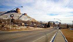
Downtown Green River, looking east at Flaming Gorge Way. | |
 Location of Green River, Wyoming | |
 Green River, Wyoming Location in the United States | |
| Coordinates: 41°30′51″N 109°27′54″W / 41.51417°N 109.46500°WCoordinates: 41°30′51″N 109°27′54″W / 41.51417°N 109.46500°W | |
| Country | United States |
| State | Wyoming |
| County | Sweetwater |
| Area[1] | |
| • Total | 14.02 sq mi (36.31 km2) |
| • Land | 13.73 sq mi (35.56 km2) |
| • Water | 0.29 sq mi (0.75 km2) |
| Elevation | 6,115 ft (1,864 m) |
| Population (2010)[2] | |
| • Total | 12,515 |
| • Estimate (2012[3]) | 12,801 |
| • Density | 911.5/sq mi (351.9/km2) |
| Time zone | Mountain (MST) (UTC-7) |
| • Summer (DST) | MDT (UTC-6) |
| ZIP codes | 82935, 82938 |
| Area code(s) | 307 |
| FIPS code | 56-33740[4] |
| GNIS feature ID | 1589126[5] |
| Website | Town of Green River Wyoming |

Green River is a city in and the county seat of Sweetwater County, Wyoming, United States, in the southwestern part of the state.[6] The population was 12,515 at the 2010 census.
History
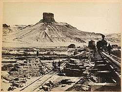
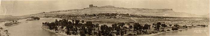
Green River was incorporated in 1868 in what was then the Dakota Territory, on the banks of the Green River. The city was the starting point from which John Wesley Powell started his famous expeditions of the Green River, the Colorado River, and the Grand Canyon in the late 1800s.[7] The town of Green River was originally supposed to be the site of a division point for the Union Pacific Railroad, but when the railroad finally reached the point, officials were surprised to find that the large town had already been established there, likely requiring costly negotiations for railroad land. They moved the division point 12 miles (19 km) west, creating the town of Bryan, on the Blacks Fork of the Green River.[8]
At the time of its incorporation in 1868, Green River had about 2000 residents and permanent adobe buildings were being built. However, when the division point of the railroad was moved west, the settlement shrank to a mere 101 residents. Just when Green River was on the verge of becoming a ghost town, Blacks Fork dried up during a drought and the railroad was forced to move the division point back to Green River to ensure adequate water for its steam locomotives. The town was officially re-incorporated under the new laws of Wyoming on May 5, 1891, while Bryan became the ghost town.
The city is known as being one of the first in the United States to ban door-to-door solicitation, under the Green River Ordinance.[9]
Industry
The Green River Basin contains the world's largest known deposit of trona ore. Soda ash mining from trona veins 900 and 1,600 feet (490 m) deep is a major industrial activity in the area, employing over 2000 persons at five mines. The mining operation is less expensive for production of soda ash in the United States than the synthetic Solvay process, which predominates in the rest of the world. The trona in Sweetwater County was created by an ancient body of water known as Lake Gosiute. Over time, the lake shrank. With the loss of outflows, highly alkaline water (salt brine) began to evaporate, depositing the beds of trona.[10]
The four mines are run by these companies:
- Tata Chemicals Ltd.
- Tronox Limited
- OCI Wyoming LP
- Solvay Chemicals Inc.
The Green River Basin also has large oil shale and natural gas reserves, which remain virtually untouched due to the high cost of extracting the oil from the hard shale formations. However, an increase in oil prices in 2008 and a national desire to become more energy independent led to an increase in well drilling and oil exploration. Expansion growth from Halliburton and Exxon, as well as other oil companies, created a mini-boom for Green River and its sister city, Rock Springs.
Geography

Green River is located at 41°30′51″N 109°27′54″W / 41.51417°N 109.46500°W (41.514189, -109.464926).[11] The elevation is 6100 feet (1859 m) above sea level.
According to the United States Census Bureau, the city has a total area of 14.02 square miles (36.31 km2), of which, 13.73 square miles (35.56 km2) is land and 0.29 square miles (0.75 km2) is water.[1]
Climate
Green River experiences a semi-arid climate (Köppen BSk) with long, cold, dry winters and hot, slightly wetter summers.
| Climate data for Green River, Wyoming | |||||||||||||
|---|---|---|---|---|---|---|---|---|---|---|---|---|---|
| Month | Jan | Feb | Mar | Apr | May | Jun | Jul | Aug | Sep | Oct | Nov | Dec | Year |
| Record high °F (°C) | 60 (16) |
68 (20) |
74 (23) |
86 (30) |
94 (34) |
103 (39) |
104 (40) |
100 (38) |
98 (37) |
89 (32) |
73 (23) |
66 (19) |
104 (40) |
| Average high °F (°C) | 32.6 (0.3) |
37.6 (3.1) |
48.3 (9.1) |
58.4 (14.7) |
68.6 (20.3) |
79.3 (26.3) |
86.0 (30) |
84.5 (29.2) |
74.5 (23.6) |
62.5 (16.9) |
44.7 (7.1) |
34.6 (1.4) |
59.3 (15.17) |
| Daily mean °F (°C) | 18.9 (−7.3) |
23.3 (−4.8) |
35.0 (1.7) |
43.4 (6.3) |
52.3 (11.3) |
61.2 (16.2) |
67.4 (19.7) |
65.5 (18.6) |
55.7 (13.2) |
44.6 (7) |
30.5 (−0.8) |
20.2 (−6.6) |
43.17 (6.21) |
| Average low °F (°C) | 5.2 (−14.9) |
9.0 (−12.8) |
21.6 (−5.8) |
28.3 (−2.1) |
36.0 (2.2) |
43.1 (6.2) |
48.8 (9.3) |
46.5 (8.1) |
36.9 (2.7) |
26.6 (−3) |
16.2 (−8.8) |
5.8 (−14.6) |
27 (−2.79) |
| Record low °F (°C) | −40 (−40) |
−41 (−41) |
−26 (−32) |
−2 (−19) |
13 (−11) |
24 (−4) |
31 (−1) |
26 (−3) |
4 (−16) |
−5 (−21) |
−19 (−28) |
−42 (−41) |
−42 (−41) |
| Average precipitation inches (mm) | 0.42 (10.7) |
0.36 (9.1) |
0.62 (15.7) |
0.89 (22.6) |
1.20 (30.5) |
0.79 (20.1) |
0.75 (19) |
0.63 (16) |
0.84 (21.3) |
0.68 (17.3) |
0.49 (12.4) |
0.35 (8.9) |
8.02 (203.6) |
| Source #1: NOAA (normals, 1971–2000)[12] | |||||||||||||
| Source #2: The Weather Channel (Records)[13] | |||||||||||||
Demographics

| Historical population | |||
|---|---|---|---|
| Census | Pop. | %± | |
| 1870 | 106 | — | |
| 1880 | 327 | 208.5% | |
| 1890 | 723 | 121.1% | |
| 1900 | 1,361 | 88.2% | |
| 1910 | 1,313 | −3.5% | |
| 1920 | 2,140 | 63.0% | |
| 1930 | 2,589 | 21.0% | |
| 1940 | 2,640 | 2.0% | |
| 1950 | 3,187 | 20.7% | |
| 1960 | 3,497 | 9.7% | |
| 1970 | 4,196 | 20.0% | |
| 1980 | 12,807 | 205.2% | |
| 1990 | 12,711 | −0.7% | |
| 2000 | 11,808 | −7.1% | |
| 2010 | 12,515 | 6.0% | |
| Est. 2015 | 12,465 | [14] | −0.4% |
| [15] | |||
2010 census
As of the census[2] of 2010, there were 12,515 people, 4,642 households, and 3,406 families residing in the city. The population density was 911.5 inhabitants per square mile (351.9/km2). There were 5,002 housing units at an average density of 364.3 per square mile (140.7/km2). The racial makeup of the city was 92.1% White, 0.4% African American, 0.8% Native American, 0.5% Asian, 0.1% Pacific Islander, 4.1% from other races, and 2.0% from two or more races. Hispanic or Latino of any race were 13.4% of the population.
There were 4,642 households of which 39.0% had children under the age of 18 living with them, 59.4% were married couples living together, 7.9% had a female householder with no husband present, 6.0% had a male householder with no wife present, and 26.6% were non-families. 21.6% of all households were made up of individuals and 5.7% had someone living alone who was 65 years of age or older. The average household size was 2.68 and the average family size was 3.12.
The median age in the city was 33.9 years. 28.4% of residents were under the age of 18; 8.2% were between the ages of 18 and 24; 26.6% were from 25 to 44; 28.1% were from 45 to 64; and 8.6% were 65 years of age or older. The gender makeup of the city was 51.6% male and 48.4% female.
2000 census
As of the census[4] of 2000, there were 11,808 people, 4,177 households, and 3,212 families residing in the city. The population density was 861.5 people per square mile (332.5/km²). There were 4,426 housing units at an average density of 322.9 per square mile (124.6/km²). The racial makeup of the city was 92.13% White, 0.27% African American, 1.36% Native American, 0.32% Asian, 0.06% Pacific Islander, 4.23% from other races, and 1.63% from two or more races. Hispanic or Latino of any race were 10.21% of the population.
There were 4,177 households out of which 42.5% had children under the age of 18 living with them, 64.4% were married couples living together, 8.4% had a female householder with no husband present, and 23.1% were non-families. 19.3% of all households were made up of individuals and 6.0% had someone living alone who was 65 years of age or older. The average household size was 2.80 and the average family size was 3.22.
In the city the population was spread out with 31.1% under the age of 18, 8.8% from 18 to 24, 28.9% from 25 to 44, 24.8% from 45 to 64, and 6.5% who were 65 years of age or older. The median age was 34 years. For every 100 females there were 102.8 males. For every 100 females age 18 and over, there were 100.7 males.
The median income for a household in the city was $53,164, and the median income for a family was $59,100. Males had a median income of $51,418 versus $24,306 for females. The per capita income for the city was $20,398. About 3.1% of families and 4.5% of the population were below the poverty line, including 6.0% of those under age 18 and 5.3% of those age 65 or over.
Government
Green River's government consists of a six-member city council, each of whom are elected from one of three wards. Each ward elects two members. The mayor is elected in a citywide vote. The city council was criticized in 2007 for its handling of a smoking ban, which caused several residents to question the council's motives.[16]
The Mayor of Green River is Pete Rust, who was elected in November 2014.
Education
Public education in the City of Green River is provided by Sweetwater County School District #2. Schools serving the city include: Harrison Elementary, Jackson Elementary, Truman Elementary, Washington Elementary, Monroe Intermediate School, Lincoln Middle School, and Green River High School. There is also one alternative high school campus - Expedition Academy.
Western Wyoming Community College is located in nearby Rock Springs and maintains an extension center in Green River.
Arts and culture
Flaming Gorge Days

Every year, Green River hosts Flaming Gorge Days. The festival features concerts, 3-on-3 basketball, Red Desert Road Runner 5K race, Festival in the Park, among other activities. Past musical performances at the festival have included Poison, Tesla, Everclear, Head East, Neal McCoy, REO Speedwagon, Josh Gracin, Chris LeDoux and Trick Pony.[17]
Media
Hyperlocal websites
Green River is served by two hyperlocal news websites, SweetwaterNOW.com[18] and Wyo4News.com.[19] SweetwaterNOW.com was founded in February 2013 and Wyo4News.com was founded in September 2013. Both sites provide original reporting, community updates and advertising.
Green River is served by four print publications: The Green River Star (a weekly newspaper published in Green River), The Sweetwater County Guide (a weekly shopper's guide published by The Green River Star), Rock Springs Daily Rocket-Miner, The Marquee (a media and entertainment supplement published in the Rocket-Miner) and The Mustang Express (formerly The Oracle - Western Wyoming Community College newspaper).
Radio
Four larger radio stations originate from Green River, three FM stations: KYCS, KZWB and KFRZ as well as one AM station, KUGR. Stations from Rock Springs, Wyoming can also be heard in Green River.
Notable residents
- Heather Moody, Olympic water polo silver and bronze medalist.[20]
- Curt Gowdy, a famous sports announcer, was born in Green River
References
- 1 2 "US Gazetteer files 2010". United States Census Bureau. Retrieved 2012-12-14.
- 1 2 "American FactFinder". United States Census Bureau. Retrieved 2012-12-14.
- ↑ "Population Estimates". United States Census Bureau. Retrieved 2013-06-01.
- 1 2 "American FactFinder". United States Census Bureau. Retrieved 2008-01-31.
- ↑ "US Board on Geographic Names". United States Geological Survey. 2007-10-25. Retrieved 2008-01-31.
- ↑ "Find a County". National Association of Counties. Retrieved 2011-06-07.
- ↑ City of Green River - About Green River Archived February 18, 2010, at the Wayback Machine.
- ↑ City of Green River - The Railroad Comes to Green River Archived November 18, 2008, at the Wayback Machine.
- ↑ City of Green River - Railroad Workers Demand Protection of Their Daytime Sleep Archived February 18, 2010, at the Wayback Machine.
- ↑ City of Green River Archived November 18, 2008, at the Wayback Machine.
- ↑ "US Gazetteer files: 2010, 2000, and 1990". United States Census Bureau. 2011-02-12. Retrieved 2011-04-23.
- ↑ "Climatography of the United States NO.81" (PDF). National Oceanic and Atmospheric Administration. Retrieved January 11, 2011.
- ↑ "Monthly Averages for Green River, WY". The Weather Channel. Retrieved January 13, 2011.
- ↑ "Annual Estimates of the Resident Population for Incorporated Places: April 1, 2010 to July 1, 2015". Retrieved July 2, 2016.
- ↑ "Historical Decennial Census Population for Wyoming Counties, Cities, and Towns". Wyoming Department of State / U.S. Census Bureau. Retrieved 2008-06-30.
- ↑ "2007: A memorable year for GR Council". Greenriverstar.com. 2003-08-07. Retrieved 2013-07-12.
- ↑ 0 daysto go!. "Flaming Gorge Days website". Flaminggorgedays.com. Retrieved 2013-07-12.
- ↑ http://sweetwaternow.com
- ↑ http://wyo4news.com
- ↑ City of Green River Archived November 18, 2008, at the Wayback Machine.
External links
| Wikimedia Commons has media related to Green River, Wyoming. |
Municipalities and communities of Sweetwater County, Wyoming, United States | ||
|---|---|---|
| Cities | 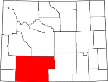 | |
| Towns | ||
| CDPs | ||
| Unincorporated communities | ||
| Ghost towns | ||
Cheyenne (capital) | |
| Topics |
|
| Society |
|
| Regions | |
| Cities | |
| Counties | |