Blue Mesa Reservoir
| Blue Mesa Reservoir | |
|---|---|
 | |
| Location | Gunnison County, Colorado |
| Coordinates | 38°28′13″N 107°13′13″W / 38.4703°N 107.2204°WCoordinates: 38°28′13″N 107°13′13″W / 38.4703°N 107.2204°W |
| Type | reservoir |
| Primary inflows | Gunnison River |
| Primary outflows | Gunnison River |
| Basin countries | United States |
| Max. length | 20 mi (32 km) |
| Surface area | 9180 acres (3715 ha) |
| Water volume | 940,800 acre feet (1.1605×10⁹ m3) |
| Shore length1 | 96 mi (154 km) |
| Surface elevation | 7,519 ft (2,292 m) |
| 1 Shore length is not a well-defined measure. | |
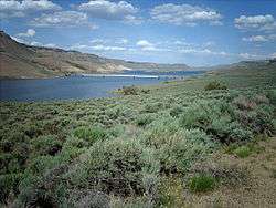
Blue Mesa Reservoir (elevation 7,519 feet (2,292 m)) is the largest body of water entirely in Colorado. Created by Blue Mesa Dam, Blue Mesa Reservoir is 20 miles (32 km) long, has 96 miles (154 km) of shoreline, and is the largest lake trout and Kokanee salmon fishery in Colorado. Blue Mesa Dam was completed in 1965 and was the first large dam built along the Gunnison River.
U.S. 50 travels along the banks of the lake, and crosses it on the Lake Fork Arm and at Middle Bridge.
The reservoir is located in the Curecanti National Recreation Area, in Western Colorado, between Montrose and Gunnison. It is one of the three reservoirs formed from the Gunnison River. The other two reservoirs, also located in Curecanti National Recreation Area, are Crystal Reservoir and Morrow Point Reservoir. The area is filled with beautiful mesas, deep narrow canyons, and fjord-like lakes. Covering 41,972 acres (169.85 km2), the park brings over 960,000 visitors each year. There is no entrance fee.
Recreation activities
Popular recreation activities include boating, fishing, wind surfing, waterskiing and ice fishing in the winter. Other activities that are not water-based are hunting, ATV-riding, hiking, horseback riding, visiting the 5,000-acre (20 km2) archeological district and exploring the old narrow-gauge mining railroad of Gunnison. In the area, there are trails ranging from easy to very strenuous. Close to the park, attractions include the Black Canyon of the Gunnison National Park and the Gunnison Gorge National Conservation Area. Visitor centers are located at Blue Mesa Point, which overlooks where the lake and the Black Canyon of the Gunnison meet, Elk Creek Marina and Cimarron. There are also overlooks at Dillon Pinnacles trail and Hermit's Rest trail.
Climate
The Blue Mesa Reservoir sits on an area of "high desert" land in Western Colorado, just west of Gunnison. Although not quite as hot as other towns west on these desert lands, it can be very comfortable and warm in the summer months. However, winter months can have exceedingly cold temperatures, with the average January low temperatures just under 0 °F (−18 °C). Rainfall is scarce, averaging only 9 inches (230 mm). It does snow on these desert lands, but the snowfall usually melts quickly due to the high altitude, dry climate, and abundant sunshine, even in the winter months.
| Climate data for Blue Mesa Reservoir | |||||||||||||
|---|---|---|---|---|---|---|---|---|---|---|---|---|---|
| Month | Jan | Feb | Mar | Apr | May | Jun | Jul | Aug | Sep | Oct | Nov | Dec | Year |
| Average high °F (°C) | 27.9 (−2.3) |
33.1 (0.6) |
44.6 (7) |
55.4 (13) |
66.8 (19.3) |
76.7 (24.8) |
83.0 (28.3) |
80.5 (26.9) |
73.2 (22.9) |
60.8 (16) |
43.9 (6.6) |
30.0 (−1.1) |
56.3 (13.5) |
| Average low °F (°C) | −0.4 (−18) |
4.3 (−15.4) |
17.1 (−8.3) |
25.7 (−3.5) |
33.2 (0.7) |
40.1 (4.5) |
46.7 (8.2) |
46.5 (8.1) |
38.4 (3.6) |
28.0 (−2.2) |
17.5 (−8.1) |
3.8 (−15.7) |
25.1 (−3.8) |
| Average precipitation inches (mm) | 0.88 (22.4) |
0.70 (17.8) |
0.47 (11.9) |
0.44 (11.2) |
0.50 (12.7) |
0.59 (15) |
1.13 (28.7) |
1.36 (34.5) |
0.99 (25.1) |
0.94 (23.9) |
0.67 (17) |
0.77 (19.6) |
9.43 (239.5) |
| Average snowfall inches (cm) | 13.7 (34.8) |
12.1 (30.7) |
5.9 (15) |
2.9 (7.4) |
0.4 (1) |
0.0 (0) |
0.0 (0) |
0.0 (0) |
0.1 (0.3) |
1.6 (4.1) |
5.5 (14) |
12.3 (31.2) |
54.4 (138.2) |
| Source: www.wrcc.dri.edu/summary/climsmco.html [1] | |||||||||||||
See also
References
Colorado River system | |||||||||||||||
|---|---|---|---|---|---|---|---|---|---|---|---|---|---|---|---|
| Jurisdictions |
|     | |||||||||||||
| Canyons |
| ||||||||||||||
| Natural features |
| ||||||||||||||
| Tributaries | |||||||||||||||
| Engineering |
| ||||||||||||||
| Designated areas | |||||||||||||||
| Related topics | |||||||||||||||