San Carlos Lake
| San Carlos Lake | |
|---|---|
 | |
| Location | Gila / Graham / Pinal counties, Arizona, United States |
| Coordinates | 33°11′16″N 110°28′20″W / 33.18778°N 110.47222°WCoordinates: 33°11′16″N 110°28′20″W / 33.18778°N 110.47222°W |
| Type | reservoir |
| Primary inflows | Gila River |
| Primary outflows | Gila River |
| Basin countries | United States |
| Managing agency | San Carlos Apache Tribe Recreation & Wildlife Dept. |
| Max. length | 23 mi |
| Max. width | 2 mi |
| Surface area | 19,500 acres |
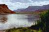
San Carlos Lake was formed by the construction of the Coolidge Dam and is rimmed by 158 miles (254 km) of shoreline. The lake is located within the 3,000-square-mile (7,800 km2) San Carlos Apache Indian Reservation, and is thus subject to tribal regulations.
After it was built, the reservoir filled gradually. Because of irrigation needs, the water level at the lake sometimes is low enough to kill its self-sustaining fish, but during wet years, the water can overtop Coolidge Dam. Since construction of the dam, the lake has been nearly empty at least 20 times, and has been full only three times.[1]
When President Calvin Coolidge dedicated the new dam in 1930, Cherokee humorist Will Rogers looked at the grass in the lake bed, and said, “If this were my dam, I’d mow it.” [2]
Recreational use
Fishing, boating and camping
San Carlos Lake is stocked periodically, and after winters with average or above average precipitation, is one of the largest lakes in Arizona. The San Carlos Apache Tribe Recreation & Wildlife Dept. stocks several species of fish using various methods to improve fishing. Several species are self-sustaining:
- sunfish (Lepomis sp.)
- largemouth bass (Micropterus salmoides)
- black crappie (Pomoxis nigromaculatus)
- channel catfish (Ictalurus punctatus)
- flathead catfish (Pylodictis olivaris)[3]
The lake has set state records for largemouth bass, black crappie and flathead catfish.[4] Other fish are stocked from cold-water fisheries including brown trout and rainbow trout.
Jet-skiing, water skiing and boating are also allowed. Individuals who are not members of the San Carlos Apache tribe who wish to use the lake must contact the tribal office for a permit since the lake is on tribal land.[3]
Soda Canyon Point Campground is located on the north side of the lake. Since the lake level varies greatly during the summer, visitors are advised to call the San Carlos Apache Recreation & Wildlife Department to determine the current lake level.[5]
References
- ↑ "San Carlos Lake, AZ". Leisure and Sports Review. Retrieved 3 June 2011.
- ↑ Coolidge Dam Celebrates 78th Anniversary | Copper Country News
- 1 2 San Carlos Apache Tribe. "Southwest Tribal Fisheries Commission". Retrieved 31 May 2011.
- ↑ "San Carlos Apache Recreation & Wildlife Department". Apache Nation Chamber of Commerce. Retrieved 3 June 2011.
- ↑ "San Carlos Apache Indian Reservation". The Arizona Handbook. Retrieved 3 June 2011.
External links
| Wikimedia Commons has media related to San Carlos Lake. |
- The American Southwest San Carlos Lake Article
- San Carlos Apache Tribe Recreation & Wildlife Dept. - hunting permission forms and information about fishing permits
- Southwest Tribal Fisheries Commission - San Carlos Apache Tribe
- San Carlos Apache Recreation & Wildlife Department
Colorado River system | |||||||||||||||
|---|---|---|---|---|---|---|---|---|---|---|---|---|---|---|---|
| Jurisdictions |
|     | |||||||||||||
| Canyons |
| ||||||||||||||
| Natural features |
| ||||||||||||||
| Tributaries | |||||||||||||||
| Engineering |
| ||||||||||||||
| Designated areas | |||||||||||||||
| Related topics | |||||||||||||||