San Juan River (Colorado River)
| San Juan River | |
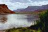
 The lower San Juan River in Utah | |
| Country | United States |
|---|---|
| States | New Mexico, Colorado, Utah |
| Tributaries | |
| - left | Navajo River, Chinle Creek |
| - right | Piedra River, Los Pinos River, Animas River |
| Source | Rocky Mountains |
| Mouth | Colorado River |
| - location | San Juan County, Utah |
| - coordinates | 37°10′47″N 110°54′03″W / 37.17972°N 110.90083°WCoordinates: 37°10′47″N 110°54′03″W / 37.17972°N 110.90083°W |
| Length | 383 mi (616 km), east-west |
| Basin | 24,600 sq mi (63,714 km2) |
| Discharge | for Bluff, UT (RM 113.5/RKM 182.7) |
| - average | 2,192 cu ft/s (62 m3/s) |
| - max | 70,000 cu ft/s (1,982 m3/s) |
| - min | 0 cu ft/s (0 m3/s) |
 Map of the San Juan River watershed | |
The San Juan River is a significant tributary of the Colorado River in the southwestern United States, about 383 miles (616 km) long.[1] The river drains an area of about 24,600 square miles (64,000 km2) in southwestern Colorado, northwestern New Mexico, southeastern Utah, and a small part of northeastern Arizona. The average flow of the San Juan River at Bluff is about 2,200 cubic feet per second (62 m3/s) and the highest discharge ever measured was about 70,000 cubic feet per second (2,000 m3/s) on September 10, 1927.
The San Juan River joins the Colorado River at Lake Powell, a huge reservoir, and in fact the westmost (and lowest) miles of the San Juan River are impounded by Lake Powell and the Glen Canyon Dam. Most of the San Juan River lies in San Juan County, New Mexico and San Juan County, Utah, which share a boundary of one point at the Four Corners. The San Juan River lies just a few miles northeast of the Four Corners point.
Geography
The San Juan River has its source in southwestern Colorado, along the southern slopes of the San Juan Mountains and to the west of the Continental Divide. The San Juan River flows southwesterly into the state of New Mexico, then westerly across New Mexico, and then northwesterly from New Mexico, and for a short distance across the very southwestern corner of Colorado, and then continues in its northwesterly course for an appreciable distance into Utah.
The largest tributary of the San Juan is the Animas River (severely affected by the EPA's accidental August 2015 Gold King Mine waste water spill), followed by the Piedra and Los Pinos rivers. The tributaries of the San Juan River that are located in Colorado also flow from the San Juan Mountains, including the Animas River, the La Plata River, the Los Pinos River, the Navajo River and the Piedra River.
The San Juan drains an arid region of North America, and along its length it is very often the only significant source of fresh water. The San Juan River is the only significant stream in the parts of the Navajo Indian Reservation that lie in New Mexico, Colorado, and Utah. Aside from Lake Powell, the only large impoundment of water along the San Juan River is at Navajo Lake, formed by the Navajo Dam in eastern San Juan County, New Mexico. Significant towns located along the San Juan River are Pagosa Springs, Colorado, the head waters of the San Juan and Farmington, New Mexico.
The San Juan River meanders through many horseshoe bends and other windings, sometimes meandering as much as 5 miles (8.0 km) within a one-mile distance "as the crow flies" (straight line, point to point), such as in Utah's Goosenecks State Park. The San Juan River flows into the Colorado River at the center of Lake Powell.
Fishing

In general, the San Juan River provides good fishing in its warm, slow, muddy waters. One section deserves special mention for its fly fishing allure: the 4.25 miles (6.84 km) just below Navajo Dam in northwest New Mexico, near the small town of Aztec. This stretch, known as the "Miracle Mile", is among the most hallowed trout fishing waters in North America.[2] The water released from the bottom of the dam is clear and cold, rich in nutrients, and flows are relatively stable. The rich waters spawn abundant flora, which in turn creates a fine environment for insect proliferation, which in turn supports one of the most prolific trout populations in any large river, both in terms of quantity and average fish size.
Other recreational activities
The Utah section of the San Juan River is a popular recreational destination. Whitewater rafting, fishing, hiking and camping are all very popular in the summer months. For travelers, the San Juan River also provides an interesting look at Native American history in the form of ruins and rock art. The banks of the San Juan contain diverse animal and plant life and many interesting geological features. The San Juan River from Bluff, Utah, to Lake Powell is managed by the Bureau of Land Management's Monticello Field Office. Permits are generally required for any type of recreation on the river.[3]
See also
| Wikimedia Commons has media related to San Juan River (Utah). |
- List of rivers of Colorado
- List of rivers of New Mexico
- List of rivers of Utah
- List of tributaries of the Colorado River
- San Juan Expedition
References
- ↑ U.S. Geological Survey. National Hydrography Dataset high-resolution flowline data. The National Map, accessed March 21, 2011
- ↑ Kreh, Lefty; Middleton, Harry (1993). Lefty's Favorite Fly Fishing Waters-Volume One-United States. Birmingham, Alabama: Odysseus Editions. pp. 91–97.
- ↑ BLM Monticello Field Office
Colorado River system | |||||||||||||||
|---|---|---|---|---|---|---|---|---|---|---|---|---|---|---|---|
| Jurisdictions |
|     | |||||||||||||
| Canyons |
| ||||||||||||||
| Natural features |
| ||||||||||||||
| Tributaries | |||||||||||||||
| Engineering |
| ||||||||||||||
| Designated areas | |||||||||||||||
| Related topics | |||||||||||||||