Mount Bierstadt
| Mount Bierstadt | |
|---|---|
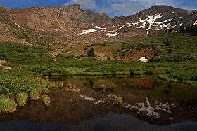 Reflections of Mt Bierstadt (right) and The Sawtooth (left) | |
| Highest point | |
| Elevation | 14,065 ft (4,287 m) [1][2] |
| Prominence | 720 ft (219 m) [3] |
| Isolation | 1.12 mi (1.80 km) [3] |
| Listing | Colorado Fourteener 38th |
| Coordinates | 39°34′57″N 105°40′08″W / 39.5825981°N 105.6687851°WCoordinates: 39°34′57″N 105°40′08″W / 39.5825981°N 105.6687851°W [1] |
| Naming | |
| Translation | Mount Beer City (German) |
| Geography | |
 Mount Bierstadt | |
| Location | Clear Creek County, Colorado, United States[4] |
| Parent range | Front Range, Chicago Peaks[3] |
| Topo map |
USGS 7.5' topographic map Mount Evans, Colorado[1] |
| Climbing | |
| First ascent | 1863 Albert Bierstadt[3] |
| Easiest route | 3 mile hike |
Mount Bierstadt (Bierstadt is German and means Beer City) is a high mountain summit of the Chicago Peaks in the Front Range of the Rocky Mountains of North America. The 14,065-foot (4,287 m) fourteener is located in the Mount Evans Wilderness of Pike National Forest, 9.4 miles (15.1 km) south by east (bearing 171°) of the Town of Georgetown in Clear Creek County, Colorado, United States.[1][2][3][4] It was named in honor of Albert Bierstadt, the American landscape painter who made the first recorded summit of the mountain in 1863.
Mountain
Mount Bierstadt is located 1.4 miles (2.2 km) west by south of Mount Evans and 43.8 miles (70.5 km) west by south of downtown Denver.
Because it is generally considered an easy climb, along with its accessibility from nearby Denver, Mount Bierstadt is one of the most popular mountains to climb in Colorado. As with most peaks in Colorado, July and August make the best months for climbing Mount Bierstadt.
The most popular base from which to begin ascent of Mount Bierstadt is Guanella Pass, located to the west. From Guanella Pass it is approximately a 3 miles (4.8 km) hike, with a climb of 2,391 feet (729 m). The trail passes descends slightly into the fairly level marshlands surrounding Scott Gomer Creek before reaching Bierstadt's western slopes. On the rocky upper regions of the mountain the route of the trail is marked by a series of cairns. The trail levels about 200 feet (61 m) below the summit at saddle point before beginning the final ascent. Alternative trails cover the eastern slopes for longer hikes.
Once at the summit, a popular option is to continue the hike to nearby Mount Evans along a ridge known as The Sawtooth, an intermediate-level hike. Often such a trip will involve a detour down to Abyss Lake 12,650 feet (3,860 m) elevation), which occupies the bottom of the valley separating Bierstadt and Evans.
Albert Bierstadt's painting A Storm in the Rocky Mountains, Mt. Rosalie is based on sketches he made during his 1863 visit to the area. That painting shows either Mount Spalding or Mount Evans (it is ambiguous) from the Chicago Lakes, 3 miles (4.8 km) north-northwest, but Bierstadt and his guide William Byers climbed onward to the summit of either Evans or Spalding (the account is ambiguous).[5]
See also
References
- 1 2 3 4 "BIERSTADT". NGS data sheet. U.S. National Geodetic Survey. Retrieved October 20, 2014.
- 1 2 The elevation of Mount Bierstadt includes an adjustment of +1.790 m (+5.87 ft) from NGVD 29 to NAVD 88.
- 1 2 3 4 5 "Mount Bierstadt, Colorado". Peakbagger.com. Retrieved October 20, 2014.
- 1 2 "Mount Bierstadt". Geographic Names Information System. United States Geological Survey. Retrieved October 29, 2014.
- ↑ William Newton Byers, Bierstadt's Visit to Colorado -- Sketching for the famous painting "Storm in the Rocky Mountains", Magazine of Western History, Vol. XI, No. 3, Jan. 1890; page 237.
External links
- Mount Bierstadt on 14ers.com
- Mount Bierstadt on Distantpeak.com
- Mount Bierstadt on TrailCentral.com
- GPS Tracks from Guanella Pass on SelectHikes.com
- Mount Bierstadt Trail (#711) on Forest Service website
- A Storm in the Rocky Mountains by Albert Bierstadt
