Wetterhorn Peak
| Wetterhorn Peak | |
|---|---|
 | |
| Highest point | |
| Elevation | 14,021 ft (4,274 m) [1][2] |
| Prominence | 1,635 ft (498 m) [2] |
| Isolation | 2.77 mi (4.46 km) [2] |
| Parent peak | Uncompahgre Peak[2] |
| Listing | Colorado Fourteener 50th |
| Coordinates | 38°03′38″N 107°30′39″W / 38.0605503°N 107.5108924°WCoordinates: 38°03′38″N 107°30′39″W / 38.0605503°N 107.5108924°W [3] |
| Naming | |
| Translation | Weather Peak (German) |
| Geography | |
 Wetterhorn Peak | |
| Location | Hinsdale and Ouray counties, Colorado, United States[3] |
| Parent range | San Juan Mountains[2] |
| Topo map |
USGS 7.5' topographic map Wetterhorn Peak, Colorado[3] |
| Climbing | |
| First ascent | 1906 by George Barnard, C. Smedley, W. P. Smedley, D. Utter (first recorded ascent)[2][4] |
| Easiest route | Southeast ridge: exposed scramble, class 3/4[4][5] |
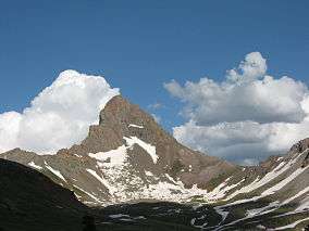
Wetterhorn Peak (Wetterhorn is German and means Weather Horn/Peak) is a fourteen thousand foot mountain peak in the U.S. state of Colorado. It is located in the Uncompahgre Wilderness of the northern San Juan Mountains, in northwestern Hinsdale County and southeastern Ouray County, 9 miles (14 km) east of the town of Ouray. It lies 2.75 mi (4.4 km) west of Uncompahgre Peak.
Wetterhorn Peak, and its neighbor Matterhorn Peak, 13,590 ft (4,142 m), are named after the Wetterhorn and the Matterhorn, two famous peaks in the Swiss Alps. Both Colorado peaks are pointed rock spires (hence resembling their namesake peaks), whose shapes contrast with the broad bulk of the higher Uncompahgre Peak.[5]
The first recorded ascent of the peak was made in 1906 by George Barnard, C. Smedley, W. P. Smedley, and D. Utter,[2] but a previous ascent by miners working in the area in the 19th century is likely.[4]
The standard, and only common, route on Wetterhorn Peak is the southeast ridge, which is accessed via the Matterhorn Creek drainage on the south side of the mountain. The trailhead is on the Henson Creek Road, accessible from Lake City. The route involves 3,535 ft (1,077 m) of ascent from the trailhead and some exposed scrambling (Class 3/4) on the ridge itself. The nearby east face is considered a high-quality advanced snow climb or extreme ski descent.[5]
See also
References
- ↑ The elevation of Wetterhorn Peak includes an adjustment of +1.903 m (+6.24 ft) from NGVD 29 to NAVD 88.
- 1 2 3 4 5 6 7 "Wetterhorn Peak, Colorado". Peakbagger.com. Retrieved October 23, 2014.
- 1 2 3 "Wetterhorn Peak". Geographic Names Information System. United States Geological Survey. Retrieved October 23, 2014.
- 1 2 3 "Wetterhorn Peak". Summitpost.
- 1 2 3 Louis W. Dawson II. Dawson's Guide to Colorado's Fourteeners, Volume 2. Blue Clover Press. pp. 115–121. ISBN 0-9628867-2-6.
External links
- Wetterhorn Peak on 14ers.com
- Topographic map from USGS via Microsoft Research Maps
- Wetterhorn Peak on Distantpeak.com
