Brock Hall, Maryland
| Brock Hall | |
|---|---|
| Census-designated place | |
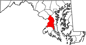
 Brock Hall  Brock Hall Location within the state of Maryland | |
| Coordinates: 38°50′54″N 76°45′52″W / 38.84833°N 76.76444°WCoordinates: 38°50′54″N 76°45′52″W / 38.84833°N 76.76444°W | |
| Country |
|
| State |
|
| County |
|
| Area | |
| • Total | 13.7 sq mi (35.6 km2) |
| • Land | 13.6 sq mi (35.3 km2) |
| • Water | 0.1 sq mi (0.3 km2) |
| Population (2010) | |
| • Total | 9,552 |
| • Density | 690/sq mi (270/km2) |
| Time zone | Eastern (EST) (UTC-5) |
| • Summer (DST) | EDT (UTC-4) |
| GNIS feature ID | 597135 |
Brock Hall is an unincorporated area and census-designated place in eastern Prince George's County, Maryland, United States, located south of Bowie and north of Upper Marlboro.[1] As of the 2010 census, the CDP had a population of 9,552.[2]
Geography
Brock Hall is located in eastern Prince George's County, approximately 11 miles (18 km) east of the boundary of the District of Columbia and 2 miles (3 km) north of Upper Marlboro, the county seat. U.S. Route 301 forms the eastern boundary of the community. Maryland Route 202 runs through the CDP, connecting Upper Marlboro to the southeast with Kettering and Largo to the northwest.
As of the 2010 census, the CDP had a total area of 13.7 square miles (35.6 km2), of which 13.6 square miles (35.3 km2) was land and 0.12 square miles (0.3 km2), or 0.98%, was water.[3]
References
- ↑ U.S. Geological Survey Geographic Names Information System: Brock Hall, Maryland
- ↑ "Profile of General Population and Housing Characteristics: 2010 Demographic Profile Data (DP-1): Brock Hall CDP, Maryland". U.S. Census Bureau, American Factfinder. Archived from the original on September 11, 2013. Retrieved December 15, 2011.
- ↑ "Geographic Identifiers: 2010 Demographic Profile Data (G001): Brock Hall CDP, Maryland". U.S. Census Bureau, American Factfinder. Archived from the original on September 11, 2013. Retrieved December 15, 2011.