Konterra, Maryland
| Konterra, Maryland | |
|---|---|
| CDP | |
 Konterra | |
| Coordinates: 39°04′12″N 76°53′54″W / 39.07000°N 76.89833°WCoordinates: 39°04′12″N 76°53′54″W / 39.07000°N 76.89833°W | |
| Country |
|
| State |
|
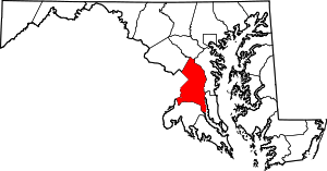
| County |
|
| Area | |
| • Total | 6.4 sq mi (16.5 km2) |
| • Land | 6.3 sq mi (16.4 km2) |
| • Water | 0.08 sq mi (0.2 km2) |
| Elevation | 138 ft (42 m) |
| Population (2010) | |
| • Total | 2,527 |
| • Density | 400/sq mi (150/km2) |
| Time zone | Eastern (EST) (UTC-5) |
| • Summer (DST) | EDT (UTC-4) |
| Area code(s) | 301 |
Konterra is an unincorporated area and census-designated place (CDP) in Prince George's County, Maryland, United States. The population was 2,527 at the 2010 census.[1]
Geography
Konterra is located at 39°04′13″N 76°53′55″W / 39.0702°N 76.8986°W.[2]
According to the United States Census Bureau, the CDP has a total area of 6.4 square miles (16.5 km2), of which 6.3 square miles (16.4 km2) is land and 0.04 square miles (0.1 km2), or 1.05%, is water.[3]
Konterra is located in northern Prince George's County, around the interchange of Interstate 95 and Maryland Route 200. The city of Laurel borders the CDP to the northeast. West Laurel lies to the north, and South Laurel is to the east. Beltsville is to the south, and Calverton is to the southwest. To the northwest, in Montgomery County, is Burtonsville.[4]
References
- ↑ "Profile of General Population and Housing Characteristics: 2010 Demographic Profile Data (DP-1): Konterra CDP, Maryland". U.S. Census Bureau, American Factfinder. Archived from the original on September 11, 2013. Retrieved December 20, 2011.
- ↑ "US Gazetteer files: 2010, 2000, and 1990". United States Census Bureau. 2011-02-12. Retrieved 2011-04-23.
- ↑ "Geographic Identifiers: 2010 Demographic Profile Data (G001): Konterra CDP, Maryland". U.S. Census Bureau, American Factfinder. Archived from the original on September 11, 2013. Retrieved December 20, 2011.
- ↑ "P.L. 94-171 County Block Maps (2010 Census) - Prince George's County, Maryland". U.S. Census Bureau. Retrieved December 20, 2011.