Bowie, Maryland
| Bowie, Maryland | ||
|---|---|---|
| City | ||
| City of Bowie | ||
|
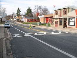
Old Town Bowie, as seen from the intersection of Maryland Route 564 and Chapel Avenue in January 2008 | ||
| ||
| Motto: "Growth, Unity and Progress" | ||
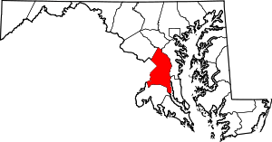
 Location of Bowie in the State of Maryland | ||
| Coordinates: 38°57′53″N 76°44′40″W / 38.96472°N 76.74444°WCoordinates: 38°57′53″N 76°44′40″W / 38.96472°N 76.74444°W | ||
| Country |
| |
| State |
| |
| County |
| |
| Incorporated | 1916 | |
| Government | ||
| • Mayor | G. Frederick Robinson | |
| Area[1] | ||
| • Total | 18.51 sq mi (47.94 km2) | |
| • Land | 18.43 sq mi (47.73 km2) | |
| • Water | 0.08 sq mi (0.21 km2) | |
| Elevation | 154 ft (47 m) | |
| Population (2010 U.S. Census)[2] | ||
| • Total | 54,727 | |
| • Estimate (2014)[3] | 57,646 | |
| • Density | 2,969.5/sq mi (1,146.5/km2) | |
| Time zone | EST (UTC-5) | |
| • Summer (DST) | EDT (UTC-4) | |
| ZIP codes | 20715-20721 | |
| Area code(s) | 301 | |
| FIPS code | 24-08775 | |
| GNIS feature ID | 0597104 | |
| Website |
www | |

Bowie /ˈbuːi/ is a city in Prince George's County, Maryland.[4] The population was 54,727 at the 2010 U.S. Census. Bowie has grown from a small railroad stop to the largest municipality in Prince George's County, and the fifth most populous city[5] and third largest city by area in the U.S. state of Maryland. In 2014 CNN Money ranked Bowie 28th in its Best Places to Live in America list.[6]
History
19th century
The city of Bowie owes its existence to the railway. In 1853 Colonel William Duckett Bowie obtained a charter from the Maryland legislature to construct a rail line into Southern Maryland. In 1869 the Baltimore & Potomac Railroad Company began the construction of a railroad from Baltimore to Southern Maryland, terminating in Pope's Creek. The area had already been dotted with small farms and large tobacco plantations in an economy based on agriculture and slavery. In 1870, Ben Plumb, a land speculator and developer, sold building lots around the railroad junction and named the settlement Huntington City. By 1872 the line was completed, together with a "spur" to Washington, D.C. and the entire line through Southern Maryland was completed in 1873.
Huntington City was renamed in honor of the son of William Duckett Bowie and his business partner, Oden Bowie,[7][8][9][10] who was President of the Baltimore & Potomac Railroad at the time,[11] and previously Governor of Maryland.[12] The town was subsequently rechartered as Bowie in 1880. In the early days the land was subdivided by developers into more than 500 residential building lots, to create a large town site at a junction of the Baltimore and Potomac's main line to southern Maryland, and the branch line to Washington, D.C.
20th century
By 1902 the Baltimore & Potomac was purchased by the powerful Pennsylvania Railroad. A second railroad entered the community when the Washington, Baltimore and Annapolis Electric Railway electric trolley line commenced service in 1908. The large interurban cars brought rapid transit to the area, with trains running hourly. Bowie area stations included High Bridge, Hillmeade, and the Race Track.
The convergence of the two rail systems induced the Southern Maryland Agricultural Society to build the Bowie Race Track in 1914. The track enabled the Belair Stud to become one of Maryland's premier areas for thoroughbreds. Also in 1914, a teacher-training college, or normal school as it was referred to then, was built for African-Americans, just outside the town. This now has become Bowie State University. The town of Bowie was incorporated in 1916.
Belair at Bowie
In 1957 the firm of Levitt and Sons acquired the nearby Belair Estate, the original colonial plantation of the Provincial Governor of Maryland, Samuel Ogle, and developed the residential community of Belair at Bowie. Two years later the town of Bowie annexed the Levitt properties, and then re-incorporated the now-larger area as a city in 1963. The overwhelming majority of Bowie residents today live in this 1960s Levitt planned community, whose street names are arranged in alphabetical sections. Levitt & Sons had a long history of prohibiting the sale of houses (including resale by owners) to African Americans which led to civil rights protests in Bowie in 1963.[13]
Belair Estate
The original Belair Estate contains the Belair Mansion (circa 1745), the five-part Georgian plantation house of Governor Samuel Ogle and his son Governor Benjamin Ogle. It was purchased in 1898 by the wealthy banker James T. Woodward who, on his passing in 1910, left it to his nephew, William Woodward, Sr., who became a famous horseman. Restored to reflect its 250-year-old legacy, the Mansion is listed on the National Register of Historic Places.
Belair Stable, on the Estate, was part of the famous Belair Stud, one of the premier racing stables in the 1930s, '40s, and '50s. Owned and operated by William Woodward, Sr. (1876–1953), it closed in 1957 following the death of his son, Billy Woodward. Belair had been the oldest continually operating thoroughbred horse farm in the country. It is said that the blood of Belair horses flows through the veins of every American race horse of distinction.
21st century
Bowie has an area of 16 square miles (41 km2) and about 50,000 residents with nearly 2,000 acres (8.1 km2) set aside as parks or open space. It has 72 ball fields, three community centers, an ice arena at Allen Pond Park, the Bowie Town Center, the 800-seat Bowie Center for the Performing Arts,[14] a 150-seat theatrical playhouse, a golf course, and three museums.
Bowie's rail town history is on display via the Huntington Railroad Museum, within the local rail station's restored railroad buildings. In 2006, the city reopened the Bowie Building Association building, a small brick and block structure constructed circa 1930, as a Welcome Center; it originally housed the Bowie Building Association, which helped finance much of the community's early development.
Bowie is home to the Bowie Baysox, a Class AA Eastern League professional baseball team affiliated with the Baltimore Orioles. As of 2015, the Baysox play their home games at Prince George's Stadium.
The city has recently added a senior citizens center and a gymnasium for community programs.
Geography

Bowie is located at 38°57′53″N 76°44′40″W / 38.96472°N 76.74444°W (38.964727, −76.744531).[15]
According to the United States Census Bureau, the city has a total area of 18.51 square miles (47.94 km2), of which, 18.43 square miles (47.73 km2) is land and 0.08 square miles (0.21 km2) is water.[1]
Bordering areas
- Glenn Dale (northwest)
- Crofton (northeast)
- Davidsonville (east)
- Queen Anne (southeast)
- Brock Hall (south)
- Kettering (southwest)
- Woodmore (southwest)
- Fairwood (west)
ZIP codes
ZIP codes for mail delivery in Bowie are: 20715, 20716, 20717, 20718, 20719, 20720, 20721
Climate
The climate in this area is characterized by hot, humid summers and generally mild to cool winters. According to the Köppen Climate Classification system, Bowie has a humid subtropical climate, abbreviated "Cfa" on climate maps.[16]
Demographics
| Historical population | |||
|---|---|---|---|
| Census | Pop. | %± | |
| 1920 | 677 | — | |
| 1930 | 694 | 2.5% | |
| 1940 | 767 | 10.5% | |
| 1950 | 860 | 12.1% | |
| 1960 | 1,072 | 24.7% | |
| 1970 | 35,028 | 3,167.5% | |
| 1980 | 33,695 | −3.8% | |
| 1990 | 37,589 | 11.6% | |
| 2000 | 50,269 | 33.7% | |
| 2010 | 54,727 | 8.9% | |
| Est. 2015 | 58,025 | [17] | 6.0% |
| U.S. Decennial Census[18] 2014 Estimate[3] | |||
According to a 2007 estimate, the median income for a household in the city was $99,105, and the median income for a family was $109,157. Males had a median income of $52,284 versus $40,471 for females. The per capita income for the city was $30,703. About 0.7% of families and 1.6% of the population were below the poverty line, including 1.0% of those under age 18 and 1.8% of those age 65 or over.
- Rank by Per Capita Income in Prince George's County: 7
- Rank by Per Capita Income in Maryland: 65
2010 census
As of the census[2] of 2010, there were 54,727 people, 19,950 households, and 14,264 families residing in the city. The population density was 2,969.5 inhabitants per square mile (1,146.5/km2). There were 20,687 housing units at an average density of 1,122.5 per square mile (433.4/km2). The ethnic makeup of the city was 41.4% White, 48.7% African American, 0.3% Native American, 4.1% Asian, 0.1% Pacific Islander, 1.9% from other races, and 3.6% from two or more races. Hispanic or Latino of any race were 5.6% of the population.
There were 19,950 households of which 37.0% had children under the age of 18 living with them, 53.2% were married couples living together, 14.0% had a female householder with no husband present, 4.3% had a male householder with no wife present, and 28.5% were non-families. 23.4% of all households were made up of individuals and 7.7% had someone living alone who was 65 years of age or older. The average household size was 2.73 and the average family size was 3.23.
The median age in the city was 40.1 years. 24.5% of residents were under the age of 18; 7.6% were between the ages of 18 and 24; 26.2% were from 25 to 44; 30.1% were from 45 to 64; and 11.6% were 65 years of age or older. The gender makeup of the city was 46.9% male and 53.1% female.
Government
The City of Bowie operates under a council-manager government as established by the city charter. This means that the mayor and council are responsible for making policy, passing ordinances, voting appropriations, and having overall supervisory authority in the city government.
Law enforcement
The primary law enforcement agency for the city is the Bowie Police Department. The Bowie Police Department is also aided by the Prince George's County Police, the Maryland-National Capital Park Police Department, and the Sheriff's Office as directed by authority.
Economy
Largest employers
According to the City's 2012 Comprehensive Annual Financial Report,[19] the largest employers in the city are:
| # | Employer | # of Employees |
|---|---|---|
| 1 | Inovalon | 2500 (As of March 2015) |
| 2 | Prince George's County Public Schools | 1,063 |
| 3 | City of Bowie | 418 |
| 4 | Walmart | 370 |
| 5 | Target | 300 |
Education
Primary and secondary schools
Public schools
Bowie is within the Prince George's County Public Schools system.
Area residents are zoned to Benjamin Tasker Middle School or Samuel Ogle Middle School, and Bowie High School.
Elementary schools in Bowie include Heather Hills, High Bridge, Kenilworth, Northview, Pointer Ridge, Rockledge, Tulip Grove, Whitehall, and Yorktown Elementary Schools. Two special education centers are Chapel Forge and C. Elizabeth Reig. A voc/tech school is located at Tall Oaks High School.
Private schools
Bowie is home to several private schools:
- Ascension Day Care and Kindergarten
- Belair Baptist Christian Academy
- Bowie Montessori Children's House
- Christian Community Presbyterian Church Nursery School
- Cornerstone Christian Academy
- Cresthill Christian Academy
- Grace Christian School (Grades K–8)
- Holy Trinity Episcopal Day School
- Patuxent Montessori School
- Redeemer Child Care Center
- St. Matthew's Early Education Center
- St. Pius X Regional School (Grades K–8)
Colleges and universities
Bowie State University, located north of Bowie, has been open since 1865.
Notable people
- JC Chasez, singer and former member of 'N Sync[20]
- Eva Cassidy, singer and songwriter[21]
- Kathie Lee Gifford, television host, singer, songwriter, comedian, and actress[22]
- Mike Lonergan, Head Coach of the George Washington University men's basketball team
Sports
| Team | Sport | League | Championships | Venue |
|---|---|---|---|---|
| Bowie Baysox | Baseball | Eastern League | 1 (2015) | Prince George's Stadium |
Historic sites
The following is a list of historic sites in the city of Bowie and vicinity identified by the Maryland-National Capital Park and Planning Commission:[23]
| Site Name | Image | Location | M-NCPPC Inventory Number | Comments | |
|---|---|---|---|---|---|
| 1 | Belair | 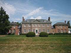 |
Tulip Grove and Belair Drives | 71B-004 | Listed on the National Register of Historic Places, 1977-09-16 |
| 2 | Belair Stables | 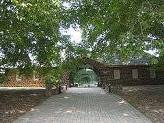 |
Belair Drive | 71B-005 | Listed on the National Register of Historic Places, 1973-05-08 |
| 3 | Bowie Railroad Buildings |  |
8614 Chestnut Ave. | 71B-002-09 | Listed on the National Register of Historic Places, 1998-11-04 |
| 4 | Boyden House | 6501 Hillmeade Road | 71A-034 | ||
| 5 | Fair Running (Maenner House) | 7704 Laurel-Bowie Road | 71B-015 | ||
| 6 | Fairview Plantation |  |
4600 Fairview Vista Drive | 71A-013 | |
| 7 | Don S. S. Goodloe House |  |
13809 Jericho Park Rd. | 71A-030 | Listed on the National Register of Historic Places, 1988-10-13; African American Heritage site |
| 8 | Governor's Bridge |  |
Governors Bridge Road at Patuxent River | 74B-001 | Historic American Engineering Record,[24] |
| 9 | Harmon-Phelps House | 8706 Maple Avenue | 71B-002-08 | ||
| 10 | Holy Trinity Episcopal Church |  |
13104 Annapolis Road | 71A-009a | |
| 11 | Holy Trinity Church Rectory | 13106 Annapolis Road | 71A-009b | ||
| 12 | Ingersoll House | 9006 Laurel-Bowie Road | 71A-003 | ||
| 13 | Knights of St. John Hall | 13004 12th Street | 71B-002-23 | ||
| 14 | Melford |  |
17107 Melford Boulevard | 71B-016 | Listed on the National Register of Historic Places, 1988-04-06; also listed at Mitchellville |
| 15 | Mitchellville Storekeeper's House and Store Site | 2608 Mitchellville Road | 71B-007 | ||
| 16 | Ryon House | 13125 11th Street | 71B-002-03 | ||
| 17 | Sacred Heart Catholic Church |  |
16101 Annapolis Road | 71A-019 | Site where the Catholic Church in America was first organized, and the first US Catholic Bishop, John Carroll was petitioned, then named by the Vatican. |
| 18 | Albert Smith House | 9201 Laurel-Bowie Road | 71A-002 | ||
| 19 | St. James Episcopal Chapel | 13010 8th Street | 71B-002-05 | ||
| 20 | Straining House | 13005 7th Street | 71B-002-01 | ||
| 21 | Williams Plains |  |
MD 3, White Marsh Recreational Park | 71B-003 | Listed on the National Register of Historic Places, 1980-11-28 |
| 22 | Pleasant Prospect |  |
12806 Woodmore Rd.,Mitchellville, Maryland | 74A-006 | Listed on the National Register of Historic Places, April 30, 1976 |
Parks
Sister Cities
| Wikivoyage has a travel guide for Bowie. |
In June 2016, Mayor Robinson gave honorary Bowie citizenship to Mayor Luigi Lucchi of Berceto, Italy as part of an International Youth Festival being held there.[26]
References
- 1 2 "US Gazetteer files 2010". United States Census Bureau. Archived from the original on 2012-01-24. Retrieved 2013-01-25.
- 1 2 "American FactFinder". United States Census Bureau. Retrieved 2013-01-25.
- 1 2 "Population Estimates". United States Census Bureau. Retrieved June 24, 2015.
- ↑ U.S. Geological Survey Geographic Names Information System: Bowie, Maryland
- ↑ "Annual Estimates of the Population for Incorporated Places in Maryland, Listed Alphabetically". United States Census Bureau. July 1, 2006. Retrieved August 29, 2015.
- ↑ "Best Places to Live 2014". Money. September 19, 2014. Retrieved September 22, 2014.
- ↑ "Revitalization of Old Town Bowie". City of Bowie, Maryland. Retrieved 2007-10-02.
- ↑ "The Prince George's Hall of Fame". Prince George's County Historical Society. 2003. Retrieved 2007-08-16.
- ↑ "Prince George's County: Over 300 years of History – Oden Bowie". Prince George's County Historical Society. 1996. Retrieved 2007-10-02.
- ↑ Wilson, William Bender (1895). History of the Pennsylvania Railroad Company: With Plan of Organization. Henry T. Coates & Company. p. 279.
- ↑ Wilson, William Bender (1895). History of the Pennsylvania Railroad Company: With Plan of Organization. Henry T. Coates & Company. pp. 333–334.
- ↑ "Governor's Information: Maryland Governor Oden Bowie". National Governors Association. Retrieved 2007-10-02.
- ↑ Suburban Legend WILLIAM LEVITT
- ↑ http://www.bowiecenter.org
- ↑ "US Gazetteer files: 2010, 2000, and 1990". United States Census Bureau. 2011-02-12. Retrieved 2011-04-23.
- ↑ Climate Summary for Bowie, Maryland
- ↑ "Annual Estimates of the Resident Population for Incorporated Places: April 1, 2010 to July 1, 2015". Retrieved July 2, 2016.
- ↑ United States Census Bureau. "Census of Population and Housing". Archived from the original on May 11, 2015. Retrieved June 24, 2015.
- ↑ "City of Bowie 2012 Comprehensive Annual Financial Report" (PDF).
- ↑ Cruz, Anne Marie (April 5, 2004). "Hit Single". People. Time, Inc. Retrieved December 21, 2013.
As a kid in suburban Bowie, Md....
- ↑ Songbird Sherri Dalphonse, Washingtonian, May 1, 2001. Retrieved on September 3, 2013.
- ↑ Gleick, Elizabeth (November 2, 1992). "Kathie Lee's Story". People. Time, Inc. 38 (18). Retrieved December 21, 2013.
When Kathie Lee was 4, the family... set up house in Bowie, Md.
- ↑ M-NCPPC Illustrated Inventory of Historic Sites (Prince George's County, Maryland), 2006.
- ↑ Lavoie, Catherine C. (1992). Historic American Engineering Record, Governor's Bridge, HAER NO. MD-85 (PDF). Washington, D.C.: National Park Service, Department of the Interior. pp. 1, 2.
- ↑ Maryland Historical Trust Property Number PG-74B-1 & AA-85I (PDF), Maryland Inventory of Historic Bridges, retrieved 5 January 2013
- ↑ "Berceto, Cittadinanza Onoraria del Bowie a Lucchi" [Berceto: Lucchi Receives Honorary Bowie Citizenship]. il Parmense (in Italian). June 14, 2016. Retrieved July 19, 2016.
| Wikimedia Commons has media related to Bowie, Maryland. |