Accokeek, Maryland
| Accokeek | |
|---|---|
| Census-designated place | |
 Location in Prince George's County | |
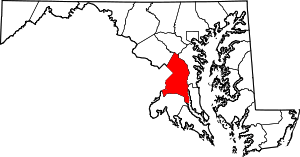
 Location of Prince George's County in Maryland | |
 Accokeek Location in the United States | |
| Coordinates: 38°40′35″N 77°00′01″W / 38.67639°N 77.00028°WCoordinates: 38°40′35″N 77°00′01″W / 38.67639°N 77.00028°W | |
| Country | United States of America |
| State | Maryland |
| County | Prince George's |
| First settled | c. 1200 |
| Founded | 1608 |
| Designated CDP | 1990 |
| Government | |
| • Type | Unincorporated |
| Area | |
| • Total | 28.803 sq mi (74.60 km2) |
| • Land | 27.436 sq mi (71.06 km2) |
| • Water | 1.367 sq mi (3.54 km2) |
| Elevation | 194 ft (59 m) |
| Population (2010) | |
| • Total | 10,573 |
| • Rank | 118th[1] |
| • Density | 370/sq mi (140/km2) |
| Time zone | Eastern (EST) (UTC-5) |
| • Summer (DST) | EDT (UTC-4) |
| ZIP code | 20607 |
| Area code | 301, 240 |
| FIPS code | 24-00250 |
| GNIS feature ID | 596993 |
Accokeek (/ɑːkˈəkiːk/), "at the edge of the hill" in Algonquin,[2] is a census-designated place (CDP) located in the US state of Maryland and the county of Prince George's. The CDP is located on the Potomac River, borders Charles County and is approximately 17 miles from Washington, D.C.. It is a part of the Washington metropolitan area. The population of the CDP, as of the 2010 United States Census was 10,573, making it the 118th most populous place in the state of Maryland.
While the area around Accokeek was occupied by Native Americans since approximately 2,000 BCE, John Smith was the first European to settle the area in 1608. In 1990, the United States Census Bureau officially made Accokeek a CDP.
History
The area around Accokeek had been occupied since around 2000 BC; however, the first permanent village was established in c. 1200 AD by the Piscataway tribe.[3] Captain John Smith was the first European to see the Accokeek area. In 1608, he sailed the Potomac River and found the Moyaone village.[4] At the time of the discovery, Moyaone was the seat of government for the Piscataway Tribe.[5] The village of Moyaone disbanded and the population migrated to other tribes before other Europeans settled the area.[6]
In mid-17th century, settlers were purchasing large plots of land for farming. The Native Americans were upset that the settlers were wearing-out the land due to farming various crops, which led to multiple battles between the two. Between 1675 and 1682, the Native Americans left the area as a result of losing.[3]
In 1861, Accokeek was still rural, and agriculture was the main economic factor for the place. Tobacco was the main crop planted.[7] During the American Civil War (1861–1865), Accokeek took the side of the Confederacy. According to the 1860 Census, the area around Accokeek had a slave population of 1,600 (52.6%). There were multiple Confederate spies in the area, including Thomas Harbin who open a hotel in the area and had plans to kidnap then-President Abraham Lincoln.[8]
Henry and Alice Ferguson settled in Accokeek when they purchased Hard Bargain Farm overlooking the Potomac River in 1922 as a vacation retreat.[9] Between 1935–39 Alice Ferguson initiated archaeological excavations to attempt to locate the original site where John Smith originally occupied. While the site was not the one described by Captain John Smith, a fort from the Susquehannock people, which was demolished in 1675, was found.[10] In 1957, US Senator Frances P. Bolton founded the Accokeek Foundation. The Foundation was used to purchase 200 acres (81 ha) of land in Piscataway Park to help preserve the area.[11]
In 1960, the Washington Suburban Sanitary Commission (WSSC) wanted to build a water treatment plant in Mockley Point, which was Accokeek shoreline. Since it would disrupt the view of Mount Vernon and Fort Washington Park, various people and organizations protested against it.[3] In 1961, a law was signed by President John F. Kennedy in order to designed 133 acres (54 ha) around Mockley Point as a national landmark. Both the Accokeek Foundation and the Alice Ferguson Foundation donated another 505 acres (204 ha) to the landmark.[12] As a result, WSSC was not allowed to build the plant there,[3] however a plant was built in the 1960s in the surrounding area.[13][14]
In 1990, Accokeek officially became a CDP when the US Census Bureau defined the place's boundaries.[15] In 2008, eight people were killed in an illegal street race.[16]
Geography
Accokeek is located in the Southern United States,[17] in Southern Maryland,[18] and approximately 17 miles (27 km) from Washington, D.C..[19] To the north, Accokeek borders the CDPs of Fort Washington and Clinton; to the east, it borders the CDP of Brandywine; to the south, it borders the CDPs of Bryans Road, Bensville, and Waldorf, all of which are located in Charles County; and to the west, it borders the Potomac River, which flows into the Chesapeake Bay.[20][21]
According to the United States Census Bureau, the place has a total area of 28.803 square miles (74.60 km2), of which 27.436 square miles (71.06 km2) is land and 1.367 square miles (3.54 km2) is water.[22] Accokeek has an average elevation of 194 feet (59 m).[23]
Climate
According to the Köppen climate classification system, Accokeek is considered to have a humid subtropical climate (Cfa).[24] This means Accokeek's average temperature of the warmest month is above 72 °F (22 °C), the average temperature of the coldest month is below between 27 to 64 °F (−3 to 18 °C), and rain is equally spread out through the year.[25]
There is more precipitation in the area during the months of May and July (4.1 inch; 104 mm) than in any other month; Accokeek currently has an annual precipitation of 39 inches (1,009 mm) each year. July is the hottest month, on average; the hottest recorded temperature occurred in July 1954 and September 1983. January is the coldest month, and the lowest recorded temperature was recorded in January 1950.[26]
| Climate data for Accokeek, MD | |||||||||||||
|---|---|---|---|---|---|---|---|---|---|---|---|---|---|
| Month | Jan | Feb | Mar | Apr | May | Jun | Jul | Aug | Sep | Oct | Nov | Dec | Year |
| Record high °F (°C) | 79 (26) |
81 (27) |
91 (33) |
95 (35) |
96 (36) |
100 (38) |
103 (39) |
102 (39) |
103 (39) |
96 (36) |
86 (30) |
77 (25) |
103 (39) |
| Average high °F (°C) | 44 (7) |
49 (9) |
58 (14) |
68 (20) |
75 (24) |
81 (27) |
85 (29) |
83 (28) |
78 (26) |
68 (20) |
59 (15) |
48 (9) |
66.3 (19) |
| Average low °F (°C) | 26 (−3) |
28 (−2) |
35 (2) |
43 (6) |
53 (12) |
62 (17) |
67 (19) |
65 (18) |
59 (15) |
47 (8) |
38 (3) |
30 (−1) |
46.1 (7.8) |
| Record low °F (°C) | −8 (−22) |
−2 (−19) |
1 (−17) |
20 (−7) |
29 (−2) |
39 (4) |
46 (8) |
45 (7) |
31 (−1) |
19 (−7) |
9 (−13) |
1 (−17) |
−8 (−22) |
| Average precipitation inches (mm) | 3.4 (86) |
3.0 (76) |
4.0 (102) |
3.1 (79) |
4.1 (104) |
3.8 (97) |
4.1 (104) |
4.6 (117) |
4.3 (109) |
3.4 (86) |
3.2 (81) |
3.2 (81) |
44.2 (1,122) |
| Source: The Weather Channel[26] | |||||||||||||
Demographics
| Historical population | |||
|---|---|---|---|
| Census | Pop. | %± | |
| 1980 | 3,894 | — | |
| 1990 | 4,477 | 15.0% | |
| 2000 | 7,349 | 64.2% | |
| 2010 | 10,573 | 43.9% | |
| Source: U.S. Census Bureau[27][28] | |||
As of the 2010 census, there were 10,573 people, 3,601 households, and 2,835 families residing in the city. The population density was 385.5 inhabitants per square mile. There were 3,816 housing units at an average density of 139.1 per square mile. Accokeek is a part of the Washington Metropolitan Area,[29] in which Accokeek contains approximately 0.19% of the MSA's population.[28]
There were 3,601 households of which 34.4% had children under the age of 18 living with them, 62.8% were married couples living together, 11.4% had a female householder with no husband present, 4.5% had a male householder with no wife present, and 21.3% were non-families. 16.8% of all households were made up of individuals and 19.9% had someone living alone who was 65 years of age or older. The average household size was 2.94, and the average family size was 3.29.[28]
The median age of the city was 41.2 years. 24.3% of residents were under the age of 18; 7.6% were between the age of 18 and 24; 25.5% were from 25 to 44; 33.5% were from 45 to 64; and 9.2% were 65 years of age or older. The gender makeup of the city was 49.2% males and 50.8% female. The racial makeup of the city was 64.4% African American, 24.9% White, 0.02% Native American, 5.5% Asian, 1.9% other races, and 2.8% from two or more races. Hispanic or Latino of any race were 4.7% of the population. As of 2013, 92.8% (9,690) of Accokeek residents spoke English at home as a primary language, while 3.2% (335) spoke Spanish and 2.4% (253) spoke Tagalog. In total, 7.1% (750) of Accokeek's population age five and older spoke another language other than English.[28]
Economy
According to the 2014 American Community Survey 5-Year Estimates, Accokeek has a median household income of $126,000, which is 2.35-times the United States' average of 53,482 and 1.69-times the State of Maryland's average of $74,149. The top industry is public administration (26.9%), followed by professional, scientific, and management, and administrative and waste management services (20.2%). Agriculture, forestry, fishing and hunting, and mining (0.2%) is the smallest industry. The unemployment rate of Accokeek was estimated to be 6.7%.[28]
Italian arms company Beretta opened a factory in Accokeek in the 1978. It won a federal contract to produce pistols for the military in 1985.[30] As of 2007, the company employed approximately 220 people, making it the largest employer in Accokeek.[31] In 2013, as a response to Maryland's Firearm Safety Act, Beretta closed the factory and moved operations to Gallatin, Tennessee in 2016.[32][33]
Parks and recreation
The following sites located at Accokeek are included on the National Register of Historic Places:
| [34] | Name on the Register | Image | Date listed[35] | Location | Description |
|---|---|---|---|---|---|
| 1 | Accokeek Creek Site |  |
(#66000909) |
Address restricted |
Site of a palisaded village that was occupied from ca. A.D. 1300 to ca. 1630. |
| 2 | Bellevue | 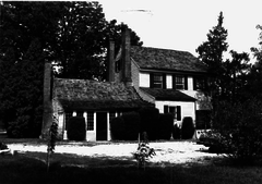 |
(#86001738) |
200 Manning Rd E 38°39′42″N 77°00′11″W / 38.661734°N 77.0029897°W |
Greek Revival style home constructed about 1840. |
| 3 | Hard Bargain Farm | .jpg) |
(#14000839) |
2001 Bryan Point Road 38°41′21″N 77°02′41″W / 38.689166666666665°N 77.04472222222222°W |
Former country estate and working farm of Alice and Henry Ferguson |
| 4 | Piscataway Park | 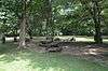 |
(#66000144) |
East of Potomac River, south of Piscataway Creek, in Prince George's and Charles Counties 38°40′43″N 77°05′34″W / 38.67861111111111°N 77.09277777777777°W |
Location of Marshall Hall and the National Colonial Farm. |
Education

Accokeek is under the Prince George's County Public Schools district. It has one public school, Accokeek Academy,[36] and one private school, Accokeek College Preparatory School.[37] There are no high schools in Accokeek, so students are zoned for either Gwynn Park High School (located in Brandywine) or Friendly High School (located in Fort Washington).[38]
According to the US Census' American Community Survey, 2.59% of the population from 25 to 64 years has less than a high school diploma, 26.17% have a high school diploma, 30.32% have some college of associate degree, and 40.90% have a bachelor's degree or higher.[28]
Transportation

The Washington Metro has bus service to Accokeek on the W-19 and W-13 Routes, which can be taken to the Southern Avenue or Branch Avenue Metro Stop.[39] The State of Maryland contracted a bus route, named the 906 Express Commuter Bus, which runs from Waldorf and Accokeek to Washington, DC.[40]
There are currently no Interstate Highways in Accokeek; however there are four state highways:[41]
Notes
- ↑ United States Census Bureau 2012, p. 43
- ↑ Bryson 2013, back cover
- 1 2 3 4 Meringolo, Denise (Winter 2008). "The Accokeek Foundation and Piscataway Park". CRM: The Journal of Heritage Stewardship. Washington DC: National Park Service. 5 (1). Archived from the original on April 1, 2016. Retrieved April 1, 2016.
- ↑ "Accokeek Creek Site". Ann Arbor, Michigan: University of Michigan. Retrieved April 13, 2016.
- ↑ Lutz, Lara (December 1, 2008). "Piscataway Park's Role Evolved from Saving a View to Sharing a Point of View". Bay Journal. Seven Valleys, Pennsylvania: Chesapeake Media Service. Retrieved April 13, 2016.
- ↑ "People, Tribes, and Bands". Maryland Government. Retrieved May 6, 2016.
- ↑ Bryson 2013, p. 30
- ↑ Bryson 2013, p. 7
- ↑ Brown, DeNeen (December 15, 2013). "At Hard Bargain Farm, City Kids make Connections with the Natural World". The Washington Post. Washington, DC. Archived from the original on April 12, 2016. Retrieved April 12, 2016.
- ↑ Grumet 1995, p. 254
- ↑ Lutz, Lara (November 1, 2005). "Piscataway Park, Rooted in Farming of Past, Sows Seeds for Future". Bay Journal. Seven Valleys, Pennsylvania: Chesapeake Media Service. Retrieved April 27, 2016.
- ↑ "Udall Accepts Gift of Land Along Potomac". The Free Lance–Star. August 28, 1962. Retrieved May 11, 2016.
- ↑ "WSSC History". Washington Suburban Sanitary Commission. Retrieved May 11, 2016.
- ↑ "Sanitary Sewer Overflow Piscataway Wastewater Treatment Plant, Accokeek, Maryland". Washington Suburban Sanitary Commission. January 30, 2008. Retrieved May 11, 2016.
- ↑ Bryon 2013, p. 8
- ↑ Graff, Michael (June 4, 2015). "Two Lanes to Accokeek". SB Nation. Vox Media. Retrieved May 11, 2016.
- ↑ United States Census Bureau. "Census Regions and Divisions of the United States" (PDF). Suitland, Maryland: United States Census Bureau. Retrieved April 18, 2016.
- ↑ "Birding in Maryland". Annapolis, Maryland: Maryland Department of Natural Resources. Retrieved April 18, 2016.
- ↑ "Distance from Accokeek, MD to Washington, DC". Distance Between Cities. Retrieved April 19, 2016.
- ↑ "Prince George's County, Maryland: Census Incorporated Places & Census Designated Places" (PDF). Baltimore, Maryland: Maryland Department of Planning. Retrieved April 25, 2016.
- ↑ "Charles County, Maryland: Census Incorporated Places & Census Designated Places" (PDF). Baltimore, Maryland: Maryland Department of Planning. Retrieved April 25, 2016.
- ↑ "2014 Gazetteer: Maryland". Suitland, Maryland: United States Census Bureau. Archived from the original on April 12, 2016. Retrieved April 12, 2016.
- ↑ "Feature Detail Report for: Accokeek". Reston, Virginia: United States Geological Survey. Archived from the original on April 12, 2016. Retrieved April 12, 2016.
- ↑ Kottek, Markus; Grieser, Jurgen; Beck, Christoph; Rudolf, Bruno; Rubel, Granz (June 2006). "World Map of the Köppen-Geiger Climate Classification Updated" (PDF). Meteorologische Zeitschrift. Stuttgart, Germany: Gebruder Borntraeger Verlagsbuchhandlung. 15 (3): 259–263. doi:10.1127/0941-2948/2006/0130. Archived (PDF) from the original on April 12, 2016. Retrieved April 12, 2016.
- ↑ The Editors of Encyclopædia Britannica (March 14, 2016). "Humid Subtropical Climate". Encyclopædia Britannica. Encyclopædia Britannica, Inc. Archived from the original on May 9, 2016. Retrieved May 9, 2016.
- 1 2 "Accokeek, MD (20607)". Atlanta, Georgia: The Weather Channel. Archived from the original on April 12, 2016. Retrieved April 2, 2016.
- ↑ United States Census Bureau 1992, p. 21
- 1 2 3 4 5 6 "Community Facts". Suitland, Maryland: United States Census Bureau. Archived from the original on April 12, 2016. Retrieved April 12, 2016.
- ↑ Revised Delineations of Metropolitan Statistical Areas, Micropolitan Statistical Areas, and Combined Statistical Areas, and Guidance on Uses of the Delineations of These Areas (PDF) (Report). Washington, D.C.: Office of Management and Budget. February 28, 2013. p. 51. Retrieved April 25, 2016.
- ↑ Meyer, Eugene; Sugawara, Sandra (November 1, 1989). "Army's Big Guns Engaged in Battle with Beretta USA". The Pittsburgh Press. Pittsburgh, Pennsylvania. p. C9. Retrieved April 1, 2016.
- ↑ Gutierrez, Liza (June 14, 2007). "Beretta Gunning for Growth in Accokeek". The Gazette. Gaithersburg, Maryland: Post Community Media LLC. Archived from the original on May 10, 2016. Retrieved May 10, 2016.
- ↑ Smith, Aaron (December 17, 2015). "Why Beretta is Moving its Gun Factory to Tennessee". Atlanta, Georgia: CNNMoney. Retrieved April 1, 2016.
- ↑ Cross, Josh (April 15, 2016). "Beretta Opens Gun plant in Gallatin". The Tennessean. Nashville, Tennessee: Gannett Company. Retrieved May 10, 2016.
- ↑ Numbers represent an ordering by significant words. Various colorings, defined here, differentiate National Historic Landmarks and historic districts from other NRHP buildings, structures, sites or objects.
- ↑ The eight-digit number below each date is the number assigned to each location in the National Register Information System database, which can be viewed by clicking the number.
- ↑ "Search for Public Schools". Washington, DC: National Center for Education Statistics. Archived from the original on April 12, 2016. Retrieved April 12, 2016.
- ↑ "Search for Public Schools". Washington, DC: National Center for Education Statistics. Archived from the original on April 12, 2016. Retrieved April 12, 2016.
- ↑ "School Finder". Upper Marlboro, Maryland: Prince George's County Public Schools. Retrieved April 20, 2016.
- ↑ CHK America (August 2015). Prince George's County, MD: Metrobus System Map (PDF) (Map). Washington, DC: Washington Metropolitan Area Transit Authority. p. 1. Archived (PDF) from the original on 2016-04-12. Retrieved April 12, 2016.
- ↑ Maryland Transit Authority (August 7, 2011). "906 Express Commuter Bus" (PDF). Baltimore, Maryland: Maryland Transit Authority. p. 1. Archived (PDF) from the original on April 12, 2016. Retrieved April 12, 2016.
- ↑ Maryland State Highway Administration (July 7, 2015). "2014 Calendar Year Highway Location Reference All intersections Data as of December 31, 2014: Prince George's County" (PDF). Baltimore, Maryland: Maryland State Highway Administration. Archived (PDF) from the original on April 12, 2016. Retrieved April 12, 2016.
References
- Bryson, Kenneth (2013). Accokeek. Charleston, South Carolina: Arcadia Publishing. ISBN 978-0-7385-9757-7. Retrieved April 22, 2016.
- Gruman, Robert (1995). Historic Contact: Indian People and Colonists in Today's Northeastern United States in the Sixteenth Through Eighteenth Centuries. Norman, Oklahoma: University of Oklahoma Press. ISBN 9780806127002. Retrieved April 22, 2016.
- United States Census Bureau (1992). "1990 Census of Population and Housing: Maryland" (PDF). Washington, D.C.: United States Department of Commerce. Retrieved April 12, 2016.
- United States Census Bureau (2012). "Maryland: 2010" (PDF). Washington, D.C.: United States Department of Commerce. Retrieved April 12, 2016.