Beltsville, Maryland
| Beltsville, Maryland | |
|---|---|
| CDP | |
|
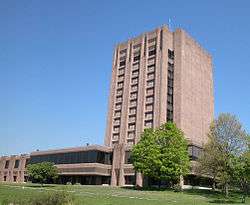
The National Agricultural Library in Beltsville, Maryland. | |
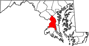
 Location of Beltsville, Maryland | |
| Coordinates: 39°2′15″N 76°55′4″W / 39.03750°N 76.91778°WCoordinates: 39°2′15″N 76°55′4″W / 39.03750°N 76.91778°W | |
| Country |
|
| State |
|
| County |
|
| Area | |
| • Total | 7.2 sq mi (18.6 km2) |
| • Land | 7.1 sq mi (18.5 km2) |
| • Water | 0.04 sq mi (0.1 km2) |
| Elevation | 135 ft (41 m) |
| Population (2010) | |
| • Total | 16,772 |
| • Density | 2,300/sq mi (900/km2) |
| Time zone | Eastern (EST) (UTC-5) |
| • Summer (DST) | EDT (UTC-4) |
| ZIP codes | 20704-20705 |
| Area code(s) | 301 |
| FIPS code | 24-06400 |
| GNIS feature ID | 0597069 |
Beltsville is a census-designated place (CDP) in northern Prince George's County, Maryland, United States.[1] The population was 16,772 at the 2010 census.[2] Beltsville includes the unincorporated community of Vansville.[3]
Geography
Beltsville is located at 39°2′15″N 76°55′4″W / 39.03750°N 76.91778°W (39.037509, -76.917847),[4] adjacent to the Montgomery County – Prince George's County line. It is about 7 miles (11 km) northeast of the Maryland border with Washington, D.C.
According to the United States Census Bureau, Beltsville has a total area of 7.2 square miles (18.6 km2), of which 7.1 square miles (18.5 km2) is land and 0.04 square miles (0.1 km2), or 0.38%, is water.[5]
Climate
The climate in this area is characterized by hot, humid summers and generally mild to cool winters. According to the Köppen Climate Classification system, Beltsville has a humid subtropical climate, abbreviated "Cfa" on climate maps.[6]
Demographics
As of the census[7] of 2000, there were 15,690 people, 5,690 households, and 3,823 families residing in Beltsville. The population density was 2,366.9 people per square mile (913.7/km²). There were 5,865 housing units at an average density of 884.8/sq mi (341.6/km²). The racial makeup of Beltsville is 48.20% White, 31.96% African American, 0.26% Native American, 10.75% Asian, 0.10% Pacific Islander, 5.42% from other races, and 3.31% from two or more races. Hispanic or Latino of any race were 9.84% of the population.
There were 5,690 households out of which 32.4% had children under the age of 18 living with them, 49.0% were married couples living together, 13.5% had a female householder with no husband present, and 32.8% were non-families. 23.0% of all households were made up of individuals and 5.1% had someone living alone who was 65 years of age or older. The average household size was 2.74 and the average family size was 3.27.
In Beltsville the population is spread out with 23.6% under the age of 18, 10.3% from 18 to 24, 34.5% from 25 to 44, 22.6% from 45 to 64, and 8.9% who were 65 years of age or older. The median age was 35 years. For every 100 females there were 94.5 males. For every 100 females age 18 and over, there were 91.8 males.
The median income for a household in Beltsville is $57,722, and the median income for a family was $66,087. Males had a median income of $40,914 versus $35,645 for females. The per capita income for the CDP was $24,679. About 5.5% of families and 7.2% of the population were below the poverty line, including 5.4% of those under age 18 and 7.2% of those age 65 or over.
History
Beltsville's history dates back to 1649, when the land was part of an 80,000-acre (324 km2) land grant given to Richard Snowden I by Lord Baltimore of England. Snowden and his family were planters who established large plantations on which they built comfortable manor homes. Soon after, other settlers moved into the area, but they were farmers who could only afford a few acres of land and whose families lived in small cabins. The principal crop was tobacco, most of which was shipped to England. Because of the fertile soil and desirable growing conditions, the crops prospered.
Industry came to Beltsville in the early 18th century when iron ore was discovered in the area. The Muirkirk Iron Furnace on US 1 was established by Andrew and Elias Elliott, who learned their iron-making skills in Muirkirk, Scotland. They produced some of the best-quality pig iron in the country and supplied the U.S. Army with cannons, shot, wheels, and other iron products during the Revolutionary War and the Civil War.
By 1730, Post Road (now part of US 1) was the main thoroughfare through Beltsville. Though crude, it made stagecoach travel possible. In 1783, Gabriel Peterson Van Horn established a stage line and built the Van Horn Tavern on Odell Road, where passengers could spend the night as they traveled between Baltimore and Washington. The trip took one and one-half days.[8]
Beltsville boasts a distinguished Revolutionary War hero as its native son. Brigadier General Rezin Beall, who was born on Turkey Flight Plantation on Old Gunpowder Road in 1723, prevented a British invasion at Drum Point on the Chesapeake Bay with only 100 men. He is credited with the fact that there are no Revolutionary War battlefields in Maryland.
In 1835 one of the first rail lines in the country, the Washington branch of the B&O Railroad, was built through Prince George's County. Coming from Baltimore, the line entered the county at Laurel and ran southwesterly to Bladensburg, then into Washington. B&O established a rail stop and freight depot on land purchased from a tobacco farmer named Trueman Belt, and they named the place after him. The new community of Beltsville was doubly blessed, for the Baltimore-Washington Turnpike crossed the rail line there. It soon became a thriving little trading center, eclipsing the older community of Vansville further north on the pike.
The original area developed haphazardly and consisted of a few residences, two churches, several small stores, a blacksmith, and a wheelwright. In 1891, the Beltsville Land Improvement Company was chartered and over the next thirty years developed the South Beltsville subdivision as a grid of streets. The developers sold the lots to individual owners and placed restrictive covenants on the deeds, including forbidding the manufacture or sale of alcohol and the sale of any property to an African American. Beltsville was marketed to professionals who wanted to escape the congestion of Washington and was developed with a mixture of Victorian-style houses and Colonial Revival houses. The community grew further when an electric railway was extended to Beltsville. The railway began as the Berwyn and Laurel Electric Railroad, but after suffering from financial difficulties it was acquired by the City and Suburban Railway. Located to the west of the railroad, along the line of present-day Rhode Island Avenue, the streetcar line served as the nucleus for additional subdivisions. These areas continued to develop slowly throughout the 1930s and 1940s with the construction of modest side-gable residences. Development continued after the introduction of the automobile, but it was not until after World War II that intensive development came to the Beltsville area.[9][10]
As the federal government grew, in 1910 the U.S. Department of Agriculture (USDA) began to purchase land in Beltsville for its Agricultural Research Service, the main in-house research arm of the USDA. The land now houses the Henry A. Wallace Beltsville Agricultural Research Center (BARC). The first parcel acquired was 375 acres (1.5 km2) of the Walnut Grange Plantation with its historic "Butterfly House". The Center eventually encompassed 14,600 acres (59 km2) and became the largest and most prominent center of agricultural science research in the world.
There are a number of historic homes and buildings still standing in Beltsville. The oldest home was built in 1773. One of the largest of the older buildings, built in 1880, was the three-story Ammendale Normal Institute, which was destroyed by fire in 1998.
Historic sites
The following is a list of historic sites in Beltsville and identified by the Maryland-National Capital Park and Planning Commission:[11] African-American Heritage Sites at nearby Rossville are listed at Muirkirk, Maryland.[12]
| Site Name | Image | Location | M-NCPPC Inventory Number | Comment | |
|---|---|---|---|---|---|
| 1 | Abraham Hall |  |
7612 Old Muirkirk Rd. | 62-023-07 | Located at Rossville. Listed on the National Register of Historic Places, 2005-03-14 |
| 2 | Ammendale Normal Institute |  |
Jct. of Ammendale Rd. and U.S. 1 | 60-004 | Listed on the National Register of Historic Places, 1975-04-14; demolished 2006 |
| 3 | Briarley Academy (Old Hotel) | 11777 Old Baltimore Pike | 62-010 | ||
| 4 | Orme-Shaw House | 11601 Caverly Avenue | 61-002 | ||
| 5 | McLeod House | 11034 Montgomery Road | 61-011 | ||
| 6 | Dr. Charles Fox House (Coffin House) | 4931 Powder Mill Road | 61-007 | ||
| 7 | Sellman House | Building 023, Beltsville Agricultural Research Center West | 61-012 | ||
| 8 | St. John’s Episcopal Church | 11040 Baltimore Avenue | 61-009 | ||
| 9 | St. Joseph’s Catholic Chapel | 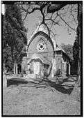 |
6011 Ammendale Road | 60-007 | Listed on the National Register of Historic Places with Ammendale Normal Institute, 1975-04-14 |
| 10 | Walnut Grange | Powder Mill Road (Building 209), Beltsville Agricultural Research Center | 62-013 |
Education
Primary and secondary schools
Public schools
Beltsville's public schools are a part of the Prince George's County Public Schools system.
Public elementary schools include:
- Beltsville Elementary School on Wicomico Avenue
- Calverton Elementary School on Beltsville Road
- Vansville Elementary School on Ammendale Road
Public middle schools include:
- Martin Luther King Middle School on Ammendale Road
Public high schools include:
- High Point High School on Powder Mill Road
Private schools
There are three parochial schools in Beltsville: Augsburg Academy (Lutheran), St Joseph's School (Roman Catholic), and Beltsville Seventh-day Adventist (SDA).
Notable businesses
- Ritz Camera Centers was headquartered in Beltsville. The chain included Ritz Camera, Wolf Camera, Kit's Camera, Inkley's, Cameras West, and The Camera Shop. The company also owned Boater's World Marine Centers, which was headquartered in the same building. The company was acquired in 2012 and the Beltsville headquarters was closed.[13]
- Beltsville Speedway, defunct NASCAR track
Notable people
- Frank Cho, comic book writer and illustrator.
- Cameron Wake, NFL player.
- Lyle Goodhue, scientist and inventor.
- Matthew Centrowitz Jr., Olympic runner
In popular culture
Experimental post-hardcore band Thrice recorded the album The Illusion of Safety here and dedicated a song to the town, named "The Beltsville Crucible".
References
- ↑ U.S. Geological Survey Geographic Names Information System: Beltsville, Maryland
- ↑ "Profile of General Population and Housing Characteristics: 2010 Demographic Profile Data (DP-1): Beltsville CDP, Maryland". U.S. Census Bureau, American Factfinder. Archived from the original on September 11, 2013. Retrieved December 15, 2011.
- ↑ "Prince George's County, MD: Census Incorporated Places & Census Designated Places" (PDF). Prince George's County Map. Maryland Department of Planning. 2009-01-29.
- ↑ "US Gazetteer files: 2010, 2000, and 1990". United States Census Bureau. 2011-02-12. Retrieved 2011-04-23.
- ↑ "Geographic Identifiers: 2010 Demographic Profile Data (G001): Beltsville CDP, Maryland". U.S. Census Bureau, American Factfinder. Archived from the original on September 11, 2013. Retrieved December 15, 2011.
- ↑ Climate Summary for Beltsville, Maryland
- ↑ "American FactFinder". United States Census Bureau. Archived from the original on 2013-09-11. Retrieved 2008-01-31.
- ↑ "Vansville site" (PDF). Retrieved 3 September 2013.
- ↑ "Community Summary Sheet, Prince George's County" (PDF). Beltsville, Maryland. Maryland State Highway Administration, 1999. 2008-05-10.
- ↑ The Neighborhoods of Prince George's County. Upper Marlboro: Community Renewal Program, 1974.
- ↑ M-NCPPC Illustrated Inventory of Historic Sites (Prince George's County, Maryland), 2006.
- ↑ M-NCPPC African-American Heritage Survey, October 1996: Properties Within or Closely Associated With Historic Communities (Prince George's County, Maryland), 1996.
- ↑ It's The End of the road for Ritz and Wolf Camera Stores
External links
| Wikivoyage has a travel guide for Beltsville. |
- Beltsville website (including links to The Beltsville News)
- Beltville Community Center and Recreation Council
- The History of Beltsville