Al-Sumayriyya
| al-Sumayriyya | |
|---|---|
|
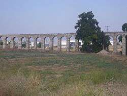
The aqueduct in al-Sumayriyya | |
 al-Sumayriyya | |
| Arabic | السُميريه |
| Name meaning | "Tawny" or "Brown"[1] |
| Also spelled | Someleria, Katasir |
| Subdistrict | Acre |
| Coordinates | 32°58′19.25″N 35°05′36.27″E / 32.9720139°N 35.0934083°ECoordinates: 32°58′19.25″N 35°05′36.27″E / 32.9720139°N 35.0934083°E |
| Palestine grid | 159/264 |
| Population | 760[2] (1945) |
| Area | 8,542[2] dunams |
| Date of depopulation | 14 May 1948[3] |
| Cause(s) of depopulation | Military assault by Yishuv forces |
| Current localities | Bustan HaGalil,[4] Lohamei HaGeta'ot,[5] Shomrat[6] |
Al-Sumayriyya (Arabic: السُميريه, Katasir in Canaanite times, Someleria during Crusader rule) was a Palestinian village located six kilometers north of Acre that was depopulated after it was captured by the Israel Defense Forces during the 1948 Arab-Israeli War.[7]
History


In the Crusader era, it was mentioned in 1277 under the name of Somelaria.[8] At the time, the village belonged to the Templars.[9] In the hudna of 1283 between Al Mansur Qalawun and the Crusaders, Al-Sumayriyya was still under Crusader rule[10][11] while in 1291 it had come under Mamluk control.[12]
A building with a court-yard, measuring 60,5 by 57 meters, dating from the Crusader era, has been noted in the village, and a 13th-century glass-factory has been excavated.[9]
Ottoman era
In 1738 Richard Pococke passed by the place, which he called Semmars. He thought the name came from "St. Mary's", and noted the remains of a wall of hewn stone, which he thought had belonged to a convent.[13]
A map by Pierre Jacotin from Napoleon's invasion of 1799 showed the place, named as El Esmerieh.[14]
In 1875 Victor Guérin found the village had 400 Muslim inhabitants.[15] In 1881, the Survey of Western Palestine described the place as a village of "mud and stone houses, containing about 200 [..] Moslems, situated on the plain, surrounded by a few clumps of olives and figs and arable land; two or three cisterns are in the village, the aqueduct near brings good water."[16]
British Mandate era
In the 1922 census of Palestine conducted by the British Mandate authorities Semariyeh had a population of 307; 300 Muslims and 7 Christians,[17] where all the Christians were Maronite.[18] This had increased in the 1931 census to 392, 390 Muslims, 1 Christian and 1 Jew, in a total of 92 houses.[19]
Al-Sumayriyya had an elementary school for boys, which was founded in 1943. In 1945, it had an enrollment of 60 students. One mosque which remains to this date, however it needs renovation.
In 1944/45 a total of 6,854 dunams were allocated to grain crops; 354 dunams were irrigated or planted with orchards,[6][20] while 28 dunams were built-up (urban) land.[21]
1948 War
At the beginning of 1945, al-Sumayriyya's 760 inhabitants were all Arab Muslims. The inhabitants fled as a result of the 14 May 1948 assault on the village by the Carmeli Brigade during Operation Ben-Ami, one day prior to the official outbreak of the 1948 Arab-Israeli War.[7] The village - along with those of neighbouring al-Bassa and al-Zib which were also captured in the offensive - was subsequently destroyed, except for its mosque.[22]
Tall al-Sumayriyya contains carved stones, a mosaic floor, tombs, columns, and stone capitals. Khirbat Abu 'Ataba has an Islamic shrine and ceramic fragments.
Lohamei HaGeta'ot was built on its site.
See also
References
- ↑ Palmer, 1881, p. 54
- 1 2 Government of Palestine, Department of Statistics. Village Statistics, April, 1945. Quoted in Hadawi, 1970, p. 41
- ↑ Morris, 2004, p.xvii, village #87. Also gives cause of depopulation
- ↑ Morris, 2004, p.xxi, settlement #36. December 1948. However, Khalidi, 1992, p.23 writes that Bustan HaGalil is on the land of Al-Manshiyya
- ↑ Morris, 2004, p. xxi, settlement #53. January 1949
- 1 2 Khalidi, 1992, p. 30
- 1 2 Welcome to Al-Sumayriyya, Palestine Remembered, retrieved 2007-12-03
- ↑ Röhricht, 1893, RRH, pp. 366-367, No. 1413; cited in Pringle, 1998, pp. 332-333
- 1 2 Pringle, 1997, p. 96
- ↑ Raynaud, 1887, p. 243, no. 490
- ↑ Barag, 1979, p. 205, no. 26
- ↑ Raynaud, 1887, p. 243, no. 490; cited in Pringle, 1998, pp. 332-333
- ↑ Pococke, 1745, vol II, p. 78; referenced in Pringle, 1997, p. 96
- ↑ Karmon, 1960, p. 162.
- ↑ Guérin, 1880, p. 161
- ↑ Conder and Kitchener, 1881, SWP I, p. 147. Also cited in Khalidi, 1992, p.30
- ↑ Barron, 1923, Table XI, Sub-district of Acre, p. 36
- ↑ Barron, 1923, Table XVI, p. 49
- ↑ Mills, 1932, p. 103
- ↑ Government of Palestine, Department of Statistics. Village Statistics, April, 1945. Quoted in Hadawi, 1970, p. 81
- ↑ Government of Palestine, Department of Statistics. Village Statistics, April, 1945. Quoted in Hadawi, 1970, p. 131
- ↑ Tal, 2004, pp. 104-105.
Bibliography
| Wikimedia Commons has media related to Al-Sumayriyya. |
- Barag, Dan (1979). "A new source concerning the ultimate borders of the Latin Kingdom of Jerusalem". Israel Exploration Journal. 29: 197–217.
- Barron, J. B., ed. (1923). Palestine: Report and General Abstracts of the Census of 1922. Government of Palestine.
- Conder, Claude Reignier; Kitchener, Herbert H. (1881). The Survey of Western Palestine: Memoirs of the Topography, Orography, Hydrography, and Archaeology. 1. London: Committee of the Palestine Exploration Fund.
- Guérin, Victor (1880). Description Géographique Historique et Archéologique de la Palestine (in French). 3: Galilee, pt. 2. Paris: L'Imprimerie Nationale.
- Hadawi, Sami (1970). Village Statistics of 1945: A Classification of Land and Area ownership in Palestine. Palestine Liberation Organization Research Center.
- Karmon, Y. (1960). "An Analysis of Jacotin's Map of Palestine" (PDF). Israel Exploration Journal. 10 (3,4): 155–173; 244–253.
- Khalidi, Walid (1992). All That Remains. Washington D.C.: Institute for Palestine Studies. ISBN 0-88728-224-5.
- Mills, E., ed. (1932). Census of Palestine 1931. Population of Villages, Towns and Administrative Areas. Jerusalem: Government of Palestine.
- Morris, Benny (2004). The Birth of the Palestinian Refugee Problem Revisited. Cambridge University Press. ISBN 978-0-521-00967-6.
- Palmer, E. H. (1881). The Survey of Western Palestine: Arabic and English Name Lists Collected During the Survey by Lieutenants Conder and Kitchener, R. E. Transliterated and Explained by E.H. Palmer. Committee of the Palestine Exploration Fund.
- Pococke, Richard (1745). A description of the East, and some other countries. 2. London: Printed for the author, by W. Bowyer : And sold by J. and P. Knapton, W. Innys, W. Meadows, G. Hawkins, S. Birt, T. Longman, C. Hitch, R. Dodsley, J. Nourse, and J. Rivington. (Pococke, 1745, vol 2, p. 54; cited in Pringle, 2009, p. 233
- Pringle, Denys (1997). Secular buildings in the Crusader Kingdom of Jerusalem: an archaeological Gazetter. Cambridge University Press.
- Pringle, Denys (1998). The Churches of the Crusader Kingdom of Jerusalem: L-Z (exluding Tyre). II. Cambridge University Press. ISBN 0 521 39037 0.
- Pringle, Denys (2009). The Churches of the Crusader Kingdom of Jerusalem: The cities of Acre and Tyre with Addenda and Corrigenda to Volumes I-III. IV. Cambridge University Press. ISBN 978-0-521-85148-0. p. 233
- Raynaud, G., ed. (1887). Les gestes des Chiprois: recueil de chroniques françaises écrites en Orient au XIIIe & XVIe ... (in French). 5. Geneve: J.G. Fick.
- Röhricht, R. (1887). "Studien zur mittelalterlichen Geographie und Topographie Syriens". Zeitschrift des Deutschen Palästina-Vereins. 10: 195–344. p. 251
- Röhricht, Reinhold (1893). (RRH) Regesta regni Hierosolymitani (MXCVII-MCCXCI) (in Latin). Berlin: Libraria Academica Wageriana.
- Tal, David (2004). War in Palestine, 1948: Strategy and Diplomacy. Routledge. ISBN 0-7146-5275-X
External links
- Welcome To al-Sumayriyya
- Survey of Western Palestine, Map 3: IAA, Wikimedia commons
- Al-Sumayriyya at Khalil Sakakini Cultural Center
- Al-Sumauriyya, Dr. Moslih Kanaaneh
- Tour to Alsumeriyya, Umar Ighbariyyeh, 25.4.2009 Zochrot