Onondaga County, New York
| Onondaga County, New York | |
|---|---|
|
Onondaga County Courthouse at Columbus Circle in Syracuse | |
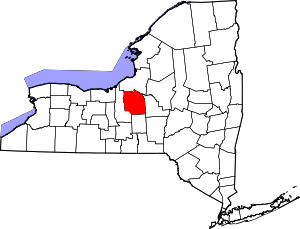 Location in the U.S. state of New York | |
 New York's location in the U.S. | |
| Founded | 1794 |
| Named for | Onondaga people |
| Seat | Syracuse |
| Largest city | Syracuse |
| Area | |
| • Total | 806 sq mi (2,088 km2) |
| • Land | 778 sq mi (2,015 km2) |
| • Water | 27 sq mi (70 km2), 3.4% |
| Population | |
| • (2010) | 467,026 |
| • Density | 600/sq mi (232/km²) |
| Congressional district | 24th |
| Time zone | Eastern: UTC-5/-4 |
| Website |
www |

Onondaga County (/ˈɒnənˈdɑːɡə/ ON-ən-DAH-gə) is a county in the U.S. state of New York. As of the 2010 census, the population was 467,026.[1] The county seat is Syracuse.[2]
Onondaga County is part of the Syracuse, NY Metropolitan Statistical Area.
Joanie Mahoney (R) is the current County Executive
History
The name Onondaga derives from the name of the Native American tribe who historically lived in this area at the time of European contact, one of the original Five Nations of the Haudenosaunee. They called themselves (autonym) Onoda'gega, sometimes spelled Onontakeka. The word means "People of the Hills." Sometimes the term was Onondagaono ("The People of the Hills"). The federally recognized Onondaga Nation has a 9.3 square miles (24 km2) reservation within the county, on which they have self-government.
When counties were established in New York in 1683, the present Onondaga County was part of Albany County. This was an enormous county, including the northern part of New York State as well as all of the present State of Vermont and, in theory, extending westward to the Pacific Ocean. This county was reduced in size on July 3, 1766, by the creation of Cumberland County, and further on March 16, 1770, by the creation of Gloucester County, both containing territory now in Vermont.
On March 12, 1772, what was left of Albany County was split into three parts, one remaining under the name Albany County. One of the other pieces, Tryon County, contained the western portion (and thus, since no western boundary was specified, theoretically still extended west to the Pacific). The eastern boundary of Tryon County was approximately 5 miles (8 km) west of the present city of Schenectady, and the county included the western part of the Adirondack Mountains and the area west of the West Branch of the Delaware River. The area then designated as Tryon County now includes 37 counties of New York State. The county was named for William Tryon, colonial governor of New York.

In the years prior to 1776, most of the Loyalists in Tryon County fled to Canada. The Onondaga were among four Iroquois tribes that allied with the British against the American colonists, as they hoped to end their encroachment. Instead, they were forced to cede most of their land in New York to the United States after the war. Many Onondaga went with Joseph Brant and other nations to Canada, where they received land grants in compensation and formed the Six Nations of the Grand River First Nation.
In 1784, following the peace treaty that ended the American Revolutionary War, the name of Tryon County was changed to Montgomery County. It honored General Richard Montgomery, who had captured several places in Canada and died attempting to capture the city of Quebec, and replaced the name of the hated British governor.
In 1789, Montgomery County was reduced by the splitting off of Ontario County from Montgomery. The actual area split off from Montgomery County was much larger than the present county, also including the present Allegany, Cattaraugus, Chautauqua, Erie, Genesee, Livingston, Monroe, Niagara, Orleans, Steuben, Wyoming, Yates, and part of Schuyler and Wayne Counties.
In 1791, Herkimer County was one of three counties split off from Montgomery (the other two being Otsego, and Tioga County). This was much larger than the present county, however, and was reduced by a number of subsequent splits.
In 1794, Onondaga County was split off from Herkimer County. This county was larger than the current Onondaga County, including the present Cayuga, Cortland, and part of Oswego Counties.
In 1799, Cayuga County was split off from Onondaga.
In 1808, Cortland County was split off from Onondaga.
In 1816, parts of Oneida and Onondaga Counties were taken to form the new Oswego County.
At the time Onondaga County was originally organized, it was divided into eleven towns: Homer, Pompey, Manlius, Lysander, Marcellus, Ulysses, Milton, Scipio, Ovid, Aurelius and Romulus.[3]
Central New York developed rapidly after the New Military Tract provided land in lieu of payment to Revolutionary War veterans. Migration was largely from the east, mostly from New England states. The Genesee Road, which became the Seneca Turnpike in 1800, provided access. Generally settlers preferred higher land, since they associated lowlands with disease. In time, as hillside soil was eroded by early clearing and farming, valley lands were more fertile and highly prized for agriculture as well as for water power, which was the origin of many communities. An early settler of 1823 was James Hutchinson Woodworth, a native of Washington County, NY. He helped clear land for his family's farm in this region before going on to Chicago where he became Mayor. The completion of the Erie Canal across New York state in 1825 accelerated trade, development and migration.
The city of Syracuse, New York developed relatively late, due to its marshy situation. It was incorporated as a village in 1825 and as a city in 1847; by contrast, the Village of Manlius, along the Cherry Valley and Seneca Turnpikes, was incorporated in 1813. Population of rural towns was greatest in the late nineteenth century, when more people cultivated land and farms were relatively small, supporting large households.
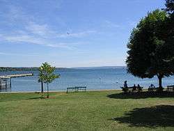
Since that time, agriculture has declined in the county. Some Onondaga County towns like Spafford, New York were largely depopulated, many villages becoming veritable ghost towns. Onondaga County highlands now are more heavily reforested, with public parks and preserves providing recreation. Two Finger Lakes in the county, Skaneateles and Otisco, also attract visitors. The village of Skaneateles on scenic Route 20 has become a major tourist destination.
At the turn of the twenty-first century, population declined in the City of Syracuse while suburban communities generally grew, particularly with tract developments north of the city. Elsewhere, scattered commuter houses appeared, generally on fairly large parcels. The village of Skaneateles and shores of Skaneateles Lake attracted rapid development, demand for property increasing property values remarkably.

Geography
According to the U.S. Census Bureau, the county has a total area of 806 square miles (2,090 km2), of which 778 square miles (2,020 km2) is land and 27 square miles (70 km2) (3.4%) is water.[4] The geographic dimensions of the county are illustrated as approximately 35 miles in length and 30 miles in width, and comprising 25 miles of the New York State Barge Canal System, in combination with a number of lakes, streams and rivers.[5] Onondaga County is in the central portion of New York State, west of Albany and Utica, east of Rochester and northeast of Ithaca. Onondaga Lake is bordered by many of the larger communities in the county.
The northern part of the county is fairly level lake plain, extending northward to Lake Ontario. Oneida Lake three rivers, as well as the Erie and subsequent Barge Canals are in the lake plain. The main line of the New York Central Railroad and the New York State Thruway extend east and west across the county through the lake plain. The southern part of the county is Appalachian Plateau, with high hills rising at the southern edge of Syracuse. This is the eastern part of the Finger Lakes region. Skaneateles Lake and Otisco Lake are both in Onondaga County. US 20 extends east and west across the county, traversing dramatic hill-and-valley terrain. Between the lake plain and Appalachian highlands is a zone noted for drumlins, smaller, scattered hills formed as mounds of debris left by the last glacier. Tully is geologically noted for the terminal moraine deposited there by the glacier, filling the deep Tully Valley, which might have been another Finger Lake, had the moraine been left closer to Syracuse, impounding water. Tully is at the divide between two major watersheds, one flowing northward to the Atlantic Ocean by way of the St. Lawrence River and the other southward to the ocean vie the Susquehanna River.[6] Oneida Lake, the Finger Lakes, and smaller bodies of water provide recreation. Several ski slopes are located in the Appalachian hills, where there are waterfalls and historic villages as attractions, as well as parks and large forest preserves.
Lakes and reservoirs

Adjacent counties

- Oswego County – north
- Madison County – east
- Cortland County – south
- Cayuga County – west
Major highways
 Interstate 81
 Interstate 481 (Veterans Memorial Highway)
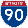 Interstate 90 (New York State Thruway)
 Interstate 690
 U.S. Route 11
 U.S. Route 20
 New York State Route 5
 New York State Route 31
 New York State Route 41
 New York State Route 92
 New York State Route 481 (Veterans Memorial Highway)
 New York State Route 690
Demographics
| Historical population | |||
|---|---|---|---|
| Census | Pop. | %± | |
| 1800 | 7,406 | — | |
| 1810 | 25,987 | 250.9% | |
| 1820 | 41,467 | 59.6% | |
| 1830 | 58,973 | 42.2% | |
| 1840 | 67,911 | 15.2% | |
| 1850 | 85,890 | 26.5% | |
| 1860 | 90,686 | 5.6% | |
| 1870 | 104,183 | 14.9% | |
| 1880 | 117,893 | 13.2% | |
| 1890 | 146,247 | 24.1% | |
| 1900 | 168,735 | 15.4% | |
| 1910 | 200,298 | 18.7% | |
| 1920 | 241,465 | 20.6% | |
| 1930 | 291,606 | 20.8% | |
| 1940 | 295,108 | 1.2% | |
| 1950 | 341,719 | 15.8% | |
| 1960 | 423,028 | 23.8% | |
| 1970 | 472,746 | 11.8% | |
| 1980 | 463,920 | −1.9% | |
| 1990 | 468,973 | 1.1% | |
| 2000 | 458,336 | −2.3% | |
| 2010 | 467,026 | 1.9% | |
| Est. 2015 | 468,463 | [7] | 0.3% |
| U.S. Decennial Census[8] 1790-1960[9] 1900-1990[10] 1990-2000[11] 2010-2013[1] | |||
As of the census[12] of 2000, 458,336 people, 181,153 households, and 115,394 families resided in the county. The population density was 587 people per square mile (227/km²). There were 196,633 housing units at an average density of 252 per square mile (97/km²). The racial makeup of the county was 84.78% White, 9.38% African American, 0.86% Native American, 2.09% Asian, 0.03% Pacific Islander, 0.89% from other races, and 1.97% from two or more races. Hispanics or Latinos of any race were 2.44% of the population. About 17.5% were of Italian, 16.2% Irish, 12.4% German, 9.4% English, and 6.0% Polish ancestry according to Census 2000, and 91.4% spoke English, 2.4% Spanish and 1.1% Italian as their first language.
Of the 181,153 households, 31.90% had children under the age of 18 living with them, 46.90% were married couples living together, 12.90% had a female householder with no husband present, and 36.30% were not families. About 29.40% of all households were made up of individuals and 10.80% had someone living alone who was 65 years of age or older. The average household size was 2.46 and the average family size was 3.07.
In the county, the population was distributed as 25.80% under the age of 18, 9.50% from 18 to 24, 28.80% from 25 to 44, 22.10% from 45 to 64, and 13.80% who were 65 years of age or older. The median age was 36 years. For every 100 females, there were 91.70 males. For every 100 females age 18 and over, there were 87.70 males.
The median income for a household in the county was $40,847, and for a family was $51,876. Males had a median income of $39,048 versus $27,154 for females. The per capita income for the county was $21,336. About 8.60% of families and 12.20% of the population were below the poverty line, including 15.50% of those under age 18 and 7.10% of those age 65 or over.
Demographic trends (2006): The county population has decreased from a high in 1970. The increasing number of housing units apparently is due to smaller family units and more individuals living alone. While the City of Syracuse population has declined, some suburban towns have grown.
Government and politics
| Year | Republican | Democratic |
|---|---|---|
| 2016 | 40.2% 78,277 | 52.8% 102,915 |
| 2012 | 38.5% 78,831 | 59.7% 122,254 |
| 2008 | 38.9% 84,972 | 59.3% 129,317 |
| 2004 | 43.8% 94,006 | 54.2% 116,381 |
| 2000 | 41.1% 83,678 | 54.0% 109,896 |
| 1996 | 37.8% 73,771 | 51.4% 100,190 |
| 1992 | 36.1% 77,642 | 42.2% 90,645 |
| 1988 | 51.9% 104,080 | 47.3% 94,751 |
| 1984 | 59.6% 121,857 | 40.0% 81,777 |
| 1980 | 50.6% 97,887 | 38.0% 73,453 |
| 1976 | 60.0% 115,474 | 39.5% 76,097 |
| 1972 | 69.2% 140,039 | 30.6% 61,895 |
| 1968 | 50.5% 95,806 | 44.0% 83,576 |
| 1964 | 32.9% 63,205 | 67.0% 128,630 |
| 1960 | 54.1% 107,170 | 45.8% 90,836 |
Onondaga County was governed exclusively by a board of supervisors until 1961, when voters approved the creation of the county executive.[14] In 1968, the board reorganized into a 24-seat county legislature.[15] In 2001, the legislature was reduced to 19 seats. The county executive is elected in a countywide vote. In a 2010 referendum, voters approved a measure to reduce the legislature to 17 seats. All 17 members are elected from individual districts. Currently, there are 13 Republicans and 4 Democrats.
Historically, Onondaga County was a Republican stronghold. The GOP carried the county in all but one presidential election from 1952 to 1988. However, it has become friendlier to Democrats in recent years; it has gone Democratic in every presidential election since 1992. At the state and local level, however, it is more of a swing county. Generally, Democratic strength is concentrated in Syracuse itself, while Republicans do well in the suburbs.
| Name | Party | Term |
|---|---|---|
| John H. Mulroy | Republican | January 1, 1962 – December 31, 1987 |
| Nicholas J. Pirro | Republican | January 1, 1988 – December 31, 2007 |
| Joanne M. Mahoney | Republican | January 1, 2008 – |
| District | Legislator | Party | Residence |
|---|---|---|---|
| 1 | Brian F. May | Republican | Baldwinsville |
| 2 | John C. Dougherty | Republican | Liverpool |
| 3 | Tim Burtis | Republican | Cicero |
| 4 | Judith Tassone | Republican | Liverpool |
| 5 | Kathleen Rapp | Republican | Liverpool |
| 6 | Michael Plochocki | Republican | Marcellus |
| 7 | Danny Liedka | Republican | East Syracuse |
| 8 | Christopher J. Ryan | Democratic | Syracuse |
| 9 | Peggy Chase | Democratic | Syracuse |
| 10 | Kevin Holmquist | Republican | East Syracuse |
| 11 | Patrick Kilmartin majority leader | Republican | Syracuse |
| 12 | David H. Knapp | Republican | LaFayette |
| 13 | Derek T. Shepard, Jr. | Republican | Syracuse |
| 14 | Casey E. Jordan | Republican | Clay |
| 15 | J. Ryan McMahon chairman | Republican | Syracuse |
| 16 | Monica Williams | Democratic | Syracuse |
| 17 | Linda Ervin | Democratic | Jamesville |
Communities

Syracuse, the county seat, is the only city in Onondaga County. The following is a list of official towns, villages, and hamlets:[16]
Towns
Villages
Census-designated places
Hamlets
Indian reservations
See also
- List of bus routes in Onondaga County, New York
- List of counties in New York
- National Register of Historic Places listings in Onondaga County, New York
- Onondaga Creek
- Timeline of town creation in Onondaga County
References
- 1 2 "State & County QuickFacts". United States Census Bureau. Retrieved October 12, 2013.
- ↑ "Find a County". National Association of Counties. Retrieved 2011-06-07.
- ↑ History of Onondaga County, Professor W. W. Clayton, 1878, retrieved 2010-08-25
- ↑ "2010 Census Gazetteer Files". United States Census Bureau. August 22, 2012. Retrieved January 6, 2015.
- ↑ Onondaga County Sheriff's Office website, October 12, 2015
- ↑ Kappel, William; Miller, Todd; Hetcher, Kari. "Hydrogeology of the Tully Lakes Area in Southern Onondaga and Northern Cortland Counties, New York" (PDF). U.S. Geological Survey. Retrieved 2016-04-04.
- ↑ "County Totals Dataset: Population, Population Change and Estimated Components of Population Change: April 1, 2010 to July 1, 2015". Retrieved July 2, 2016.
- ↑ "U.S. Decennial Census". United States Census Bureau. Retrieved January 6, 2015.
- ↑ "Historical Census Browser". University of Virginia Library. Retrieved January 6, 2015.
- ↑ "Population of Counties by Decennial Census: 1900 to 1990". United States Census Bureau. Retrieved January 6, 2015.
- ↑ "Census 2000 PHC-T-4. Ranking Tables for Counties: 1990 and 2000" (PDF). United States Census Bureau. Retrieved January 6, 2015.
- ↑ "American FactFinder". United States Census Bureau. Retrieved 2008-01-31.
- ↑ http://uselectionatlas.org/RESULTS/
- ↑ Onondaga County Charter Commission (1961-09-05), PROPOSED ONONDAGA COUNTY CHARTER ADOPTED BY THE BOARD OF SUPERVISORS SEPTEMBER 5, 1961 SUBJECT TO APPROVAL BY REFERENDUM NOVEMBER 7, 1961, Syracuse, New York, pp. 3–4
- ↑ Board Executive Office (1967), "LOCAL LAW NO. 2—1966", Journal of the Board of Supervisors of the County of Onondaga for 1966, Syracuse, New York, pp. 182–187
- ↑ New York State Gazetteer, Albany, NY: New York State Department of Health, 1995 Available at New York State Library Digital Image Project.
External links
- Onondaga County, NY official site
- Onondaga County at DMOZ
- Onondaga County, NY US GenWeb Project
- Onondaga County, NY U.S. Census Page
- Brief early history of Onondaga County and its towns
- Onondaga County Historical Aerial Photographs of New York , Cornell University Library & Cornell Institute for Resource Information Sciences
 |
Oswego County | | ||
| Cayuga County | |
Madison County | ||
| ||||
| | ||||
| Cortland County |
Municipalities and communities of Onondaga County, New York, United States | ||
|---|---|---|
| City | | |
| Towns | ||
| Villages | ||
| CDPs | ||
| Other hamlets |
| |
| Indian reservation | ||
| Footnotes | ‡This populated place also has portions in an adjacent county or counties | |
Coordinates: 43°01′N 76°12′W / 43.01°N 76.20°W