Salina, New York
| Salina, New York | |
|---|---|
| Town | |
 Location in Onondaga County and the state of New York. | |
| Coordinates: 43°6′6″N 76°10′13″W / 43.10167°N 76.17028°WCoordinates: 43°6′6″N 76°10′13″W / 43.10167°N 76.17028°W | |
| Country | United States |
| State | New York |
| County | Onondaga |
| Government | |
| • Type | Town Council |
| • Town Supervisor | Mark A. Nicotra (R) |
| • Town Council |
Members' List
|
| Area | |
| • Total | 15.1 sq mi (39.1 km2) |
| • Land | 13.8 sq mi (35.7 km2) |
| • Water | 1.3 sq mi (3.4 km2) |
| Elevation | 433 ft (132 m) |
| Population (2010) | |
| • Total | 33,710 |
| Time zone | Eastern (EST) (UTC-5) |
| • Summer (DST) | EDT (UTC-4) |
| ZIP code | 13088, 13090 |
| Area code(s) | 315 |
| FIPS code | 36-64815 |
| GNIS feature ID | 0979453 |
| Website |
salina |
Salina is a town in Onondaga County, New York, United States. The population was 33,710 at the 2010 census. The name of the town is derived from the Latin word for "salt". Salina is a northwest suburb of the city of Syracuse.
History
The region was in the domain of the Onondaga tribe and later was within the Central New York Military Tract, although it was reserved for members of the Onondagas.
Salina received its name in 1797, when the Surveyor General of New York State received authority to set aside a portion of the Onondaga Salt Springs Reservation for use in salt manufacture. The reservation had been created by a treaty with the Native Americans. The land extended one mile around Onondaga Lake. In 1798, the Village of Salina was chartered. It was located in what is now the Washington Square neighborhood or "First Ward" of the current City of Syracuse and contained sixteen blocks. Each block was divided into four house lots, selling according to law, for no less than forty dollars. The area now known as the Town of Salina was still part of the Townships of Manlius and Marcellus. In March 1809, the Town of Salina was organized. It included the areas now known as the Town of Geddes (formed 1848), part of Manlius and the City of Syracuse.
Salina's location on the Erie Canal stimulated its industrial development. The middle section of the canal, from Salina to Utica was the first to open, in 1820, and elaborate celebrations were held.
Consolidation
It was not until the late 1840s that Salina was reduced to its present size. The original Village of Salina stretched around Onondaga Lake, incorporating part of what is now the Town of Geddes and much of what today is the City of Syracuse. The early history of Salina is actually the history of the area around Onondaga Lake and the salt industry.
By 1843, it was apparent that Syracuse would soon become a city. The townspeople of both villages began discussing a proposed charter which would unify the two towns. Leading citizens urged the consolidation of Syracuse and Salina into one city, however, old political rivalries blocked any action. On January 1, 1844, a riot between the warring factions broke out in Siegel's boarding house at the corner of Washington and Warren Streets. The men from Salina who were salt boilers "descended upon the house to break up a party." Siegel resented a remark that was made about his wife and "shattered the face of one of the intruders with a shotgun."[1]
A "free for all" followed and the New York Militia was called out. The event shocked the two municipalities into action and negotiations for a city charter began. In December 1847, the act of incorporation was passed, which defined the area as "constituting a part of the Town of Salina and incorporation the Village of Salina and Syracuse." This act reduced the Town of Salina to its present boundaries.
The terms were settled on January 3, 1848 and the two villages, along with Lodi, were incorporated as the City of Syracuse. The new city had a combined population of 22,000.[1]
Today, Salina consists of five small suburban communities which are known as Liverpool, Mattydale, Lyncourt, Galeville and a portion of North Syracuse.
Part of the massive Destiny USA complex is constructed in Salina.
The Alvord House was listed on the National Register of Historic Places in 1976.[2]
Geography
According to the United States Census Bureau, the town has a total area of 15.1 square miles (39 km2), of which, 13.8 square miles (36 km2) of it is land and 1.3 square miles (3.4 km2) of it (8.74%) is water.
The town is on the north shore of Onondaga Lake.
Interstate 81 and Interstate 90 (New York State Thruway) intersect in Salina. New York State Route 370 borders Onondaga Lake. U.S. Route 11 passes through the eastern part of the town.
Demographics
| Historical population | |||
|---|---|---|---|
| Census | Pop. | %± | |
| 1820 | 1,814 | — | |
| 1830 | 6,929 | 282.0% | |
| 1840 | 11,013 | 58.9% | |
| 1850 | 2,142 | −80.6% | |
| 1860 | 2,400 | 12.0% | |
| 1870 | 2,688 | 12.0% | |
| 1880 | 2,888 | 7.4% | |
| 1890 | 3,490 | 20.8% | |
| 1900 | 3,745 | 7.3% | |
| 1910 | 3,208 | −14.3% | |
| 1920 | 4,257 | 32.7% | |
| 1930 | 10,117 | 137.7% | |
| 1940 | 11,168 | 10.4% | |
| 1950 | 19,125 | 71.2% | |
| 1960 | 33,076 | 72.9% | |
| 1970 | 38,281 | 15.7% | |
| 1980 | 37,400 | −2.3% | |
| 1990 | 35,145 | −6.0% | |
| 2000 | 33,290 | −5.3% | |
| 2010 | 33,710 | 1.3% | |
| Est. 2014 | 33,450 | [3] | −0.8% |
As of the census[5] of 2000, there were 33,290 people, 14,401 households, and 8,871 families residing in the town. The population density was 2,415.7 people per square mile (932.8/km²). There were 14,979 housing units at an average density of 1,086.9 per square mile (419.7/km²). The racial makeup of the town was 93.87% White, 2.16% African American, 0.52% Native American, 1.60% Asian, 0.04% Pacific Islander, 0.41% from other races, and 1.40% from two or more races. Hispanic or Latino of any race were 1.40% of the population.
There were 14,401 households out of which 26.0% had children under the age of 18 living with them, 46.4% were married couples living together, 11.1% had a female householder with no husband present, and 38.4% were non-families. 31.6% of all households were made up of individuals and 12.8% had someone living alone who was 65 years of age or older. The average household size was 2.30 and the average family size was 2.91.
In the town the population was spread out with 21.7% under the age of 18, 7.0% from 18 to 24, 30.0% from 25 to 44, 23.2% from 45 to 64, and 18.1% who were 65 years of age or older. The median age was 39 years. For every 100 females there were 90.1 males. For every 100 females age 18 and over, there were 86.6 males.
The median income for a household in the town was $40,500, and the median income for a family was $49,394. Males had a median income of $36,444 versus $27,179 for females. The per capita income for the town was $21,839. About 5.3% of families and 7.4% of the population were below the poverty line, including 10.2% of those under age 18 and 4.7% of those age 65 or over.
Communities and locations in Salina
- The Alvord House – A stone farmhouse on the National Register of Historic Places.
- Elmcrest – A community by the northwest corner of the town.
- Galeville – A suburb of Syracuse by the east town line and by the junction of I-81 and I-90.
- Ley Creek – A stream that forms part of the eastern town boundary.
- Liverpool – The Village of Liverpool is on NY-370 in the northwest of Salina.
- Lyncourt – A hamlet.
- Mattydale – A suburb of Syracuse in the eastern part of Salina.
- Hinsdale-- A community north of Mattydale and next to the airport.
- Long Branch – A community by Onondaga Lake in the northwest part of Salina.
- North Syracuse – Part of the Village of North Syracuse.
- Pitcher Hill – A suburban community on the north town line, west of the airport.
- Syracuse Hancock International Airport – Part of the regional airport is in the northeast part of Salina.
References
- 1 2 "New York, Syracuse". Atlantis, 2010. Retrieved November 3, 2010.
- ↑ National Park Service (2009-03-13). "National Register Information System". National Register of Historic Places. National Park Service.
- ↑ "Annual Estimates of the Resident Population for Incorporated Places: April 1, 2010 to July 1, 2014". Retrieved June 4, 2015.
- ↑ "Census of Population and Housing". Census.gov. Retrieved June 4, 2015.
- ↑ "American FactFinder". United States Census Bureau. Retrieved 2008-01-31.
External links
- Town of Salina official website
- Salina Free Library
- Salina Town Court information
- Salina history/genealogy
Municipalities and communities of Onondaga County, New York, United States | ||
|---|---|---|
| City | 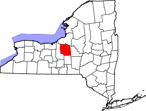 | |
| Towns | ||
| Villages | ||
| CDPs | ||
| Other hamlets |
| |
| Indian reservation | ||
| Footnotes | ‡This populated place also has portions in an adjacent county or counties | |