Old Erie Canal State Historic Park
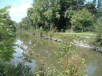
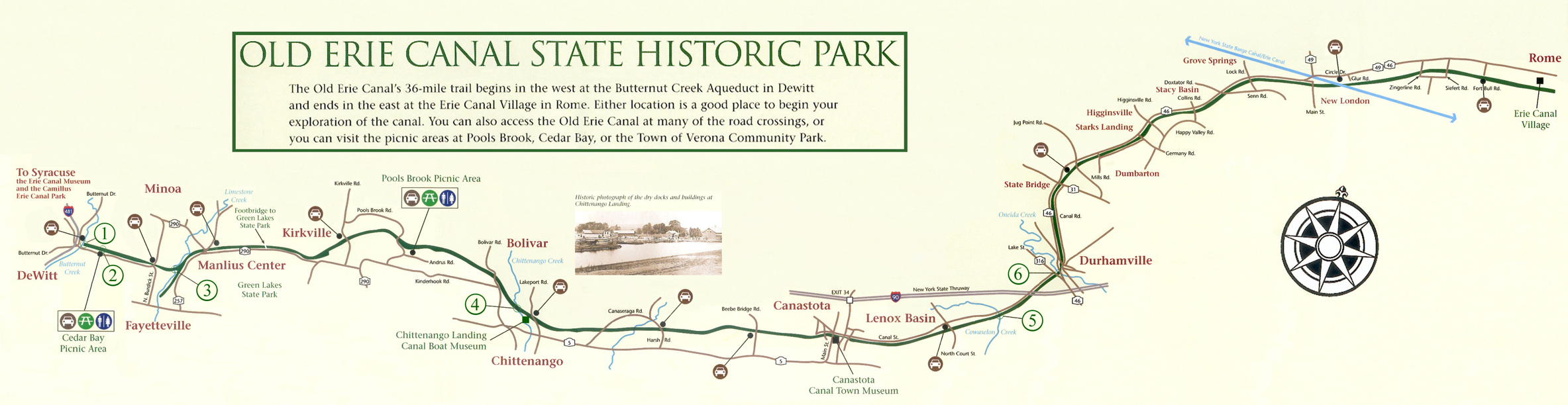
The Old Erie Canal State Historic Park encompasses a 36-mile (58 km) linear segment of the original Erie Canal's Long Level section. It extends eastward from Butternut Creek in the town of DeWitt, just east of Syracuse, to the outskirts of Rome, New York. The park includes restored segments of the canal's waterway and towpath which were in active use between 1825 and 1917. It is part of the New York State Park system.
Access
The towpath has been resurfaced with asphalt and stone dust and is suitable for biking, hiking, horseback riding or snowmobiling. The canal also is navigable by canoe or kayak for short segments throughout the park. All-terrain vehicles (ATVs) and motorcycles are not permitted, and no campsites are available in the park, although camping is available at Green Lakes State Park east of Syracuse, which is closely adjacent to Old Erie Canal State Park. Several picnic areas are available on the route and are accessible via nearby roads.
Route

The 1,191-acre (4.82 km2) park lies within Madison, Oneida, and Onondaga counties.[1] The park passes near or through several communities, including Fayetteville, Manlius Center, Kirkville, Chittenango, Canastota, Durhamville and New London.
Five miles (8.0 km) east of Butternut Creek, the canal passes by the entrance to Green Lakes State Park.
The park's terminus is at the Erie Canal Village, a now defunct privately operated museum and historic recreation of a 19th-century canal village located outside of Rome,[2] which featured a 2 ft (610 mm) narrow gauge railway.[3]
Connecting trails
Other trails connecting with the Old Erie Canal towpath trail include:[4]
- Butternut Creek Recreation and Nature Trail, DeWitt
- Fayetteville Feeder Towpath, Fayetteville
- Chittenango Creek Walk, Chittenango
- North Country Trail, Canastota (Concurrent east of Canastota to Rome)
- Oneida Rail Trail, Oneida
- Rome Canalway Towpath, Rome
Nearby parks

Other parks, museums, and recreation areas along and nearby the Old Erie Canal State Historic Park include, from west to east:[4]
- Ryder Park and Recreation Area, DeWitt
- Cedar Bay Park, DeWitt
- Canal Landing Park, Fayetteville
- Green Lakes State Park, Manlius
- Poolsbrook Picnic Area, Minoa
- Chittenango Landing Canal Boat Museum, Chittenango
- Duruss Conservancy, Oneida
- Verona Beach State Park, Verona
- Verona Park, Verona
- Lock 21 Park, New London, Oneida County
- Erie Canal Village, Rome
History
In July 2006, stretches of the old canal within the park had to be dammed or drained to effect repairs on the aqueduct over Butternut Creek east of Syracuse, which was in danger of a potentially catastrophic leak due to unusually heavy rains.
In February 2010 the park was among about 40 New York State parks recommended for closure under Governor David Paterson's austerity budget plan. The park remains open.
See also
- Chittenango Landing Dry Dock Complex
- Erie Canal Museum, Syracuse
- Erie Canalway National Heritage Corridor
- New York State Canalway Trail
References
- ↑ "Section O: Environmental Conservation and Recreation, Table O-9". 2014 New York State Statistical Yearbook (PDF). The Nelson A. Rockefeller Institute of Government. 2014. p. 673. Retrieved March 11, 2016.
- ↑ "Erie Canal Village at standstill". Rome Sentinel. June 16, 2016.
- ↑ Steamlocomotive.info - Hecla Mining Co. No. 16
- 1 2 "Old Erie Canal Trail Map" (PDF). New York State Parks, Recreation, and Historic Preservation. 16 December 2015. Retrieved 21 December 2015.
External links
| Wikimedia Commons has media related to Old Erie Canal State Historic Park. |
- Official website
- Map of the Old Erie Canal State Historic Park
- Traces of the Erie Canal in the Old Erie Canal State Historic Park
- Erie Canal Village
Coordinates: 43°04′23″N 75°55′34″W / 43.0731°N 75.9261°W