Saratoga County, New York
| Saratoga County, New York | ||
|---|---|---|
|
| ||
| ||
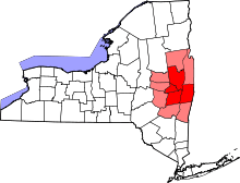
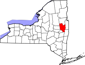 Location in the U.S. state of New York | ||
 New York's location in the U.S. | ||
| Founded | 1791 | |
| Seat | Ballston Spa | |
| Largest city | Saratoga Springs | |
| Area | ||
| • Total | 844 sq mi (2,186 km2) | |
| • Land | 810 sq mi (2,098 km2) | |
| • Water | 34 sq mi (88 km2), 4.0% | |
| Population | ||
| • Total | 226,249[1] | |
| • Density | 278/sq mi (107/km²) | |
| Congressional districts | 20th, 21st | |
| Time zone | Eastern: UTC-5/-4 | |
| Website |
www | |
|
Footnotes: Population quoted is 2015 U.S. Census estimate.[1] Highest elevation: 2,675 ft/815 m (Hadley Mountain),[2] in the Adirondack Mountains. Lowest elevation: 69 ft/21 m, at the confluence of the Hudson River and the Mohawk River. | ||


Saratoga County is a county in the U.S. state of New York. As of the 2015 U.S. Census estimate, the county's population was 226,249, representing a 3.0% increase from the 2010 population of 219,607,[1] representing one of the fastest growth rates in the northeastern United States. The county seat is Ballston Spa.[3] Saratoga County is included in the Capital District, encompassing the Albany-Schenectady-Troy, New York Metropolitan Statistical Area.
Saratoga County's name was derived from the Native American word "sah-rah-ka", or "Sarach-togue", meaning "the hill beside the river", referring to the Hudson River bordering the county on its eastern flank and the Mohawk River delineating its southern border. Saratoga County, bisected by the toll-free, six-lane Adirondack Northway, serves as an outdoor recreational haven and as the gateway to the Adirondack Mountains and State Park for the populations of the Albany and New York City metropolitan areas. The county is also home to the internationally renowned Saratoga Race Course, one of the oldest venues in horse racing.
Saratoga County lies at the heart of eastern New York State's recognized Tech Valley, a growing center for the computer hardware side of the high-technology industry and its concomitant venture capital investment, with great strides in the nanotechnology sector, digital electronics design, and water- and electricity-dependent integrated microchip circuit manufacturing, involving companies including IBM, GlobalFoundries, Samsung, and Taiwan Semiconductor, among others.[4][5][6] The "Fab 8" campus of GlobalFoundries, a company specializing in the semiconductor industry, is a multibillion-dollar venture being developed in Saratoga County.[4][7]
History
When counties were established in the Province of New York in 1683, the present Saratoga County was part of Albany County. This was an enormous county, including the northern part of New York State as well as all of the present State of Vermont and, in theory, extending westward to the Pacific Ocean. This large county was progressively reduced in size by the separation of several counties until 1791, when Saratoga County as well as Rensselaer County were split off from Albany County. The Battles of Saratoga (September 19 and October 7, 1777) marked the climax of the Saratoga campaign, giving a decisive victory to the Americans over the British in the American Revolutionary War.
During the nineteenth century, Saratoga County was an important industrial center. Its location 30 miles north of Albany on the Delaware and Hudson Railway, as well as its proximity to water power from the Hudson River and the Kayaderosseras Creek, led to rapid industrial development beginning in the early nineteenth century. Some of the most important industrial employers were paper mills, tanneries, foundries, and textile mills.[8]
Since the construction of the Adirondack Northway in the 1960s, Saratoga County has consistently been the fastest-growing county in the Capital District and indeed, in Upstate New York, and one of the fastest-growing in the U.S. Northeast. The county has historically maintained a low county tax rate; according to its official website, Saratoga County levies one of the lowest county tax rates in New York State.[9]
Geography
Saratoga County is situated in the eastern portion of New York State, north of Albany, northwest of Troy, and east of Utica. According to the U.S. Census Bureau, the county has a total area of 844 square miles (2,190 km2), of which 810 square miles (2,100 km2) is land and 34 square miles (88 km2) (4.0%) is water.[10] The Hudson River forms the eastern border of the county, while the Mohawk River demarcates its southern border. The highest elevation in Saratoga County is at the peak of Hadley Mountain in the Adirondack Mountains, at 2,675 feet (815 meters),[2] while the lowest elevation is 69 feet (21 meters), at the waterfront of the Village of Waterford, at the confluence of the Mohawk and Hudson rivers.
Adjacent counties

Demographics
| Historical population | |||
|---|---|---|---|
| Census | Pop. | %± | |
| 1800 | 24,483 | — | |
| 1810 | 33,147 | 35.4% | |
| 1820 | 36,052 | 8.8% | |
| 1830 | 38,679 | 7.3% | |
| 1840 | 40,553 | 4.8% | |
| 1850 | 45,646 | 12.6% | |
| 1860 | 51,729 | 13.3% | |
| 1870 | 51,529 | −0.4% | |
| 1880 | 55,156 | 7.0% | |
| 1890 | 57,663 | 4.5% | |
| 1900 | 61,089 | 5.9% | |
| 1910 | 61,917 | 1.4% | |
| 1920 | 60,029 | −3.0% | |
| 1930 | 63,314 | 5.5% | |
| 1940 | 65,606 | 3.6% | |
| 1950 | 74,869 | 14.1% | |
| 1960 | 89,096 | 19.0% | |
| 1970 | 121,679 | 36.6% | |
| 1980 | 153,759 | 26.4% | |
| 1990 | 181,276 | 17.9% | |
| 2000 | 200,635 | 10.7% | |
| 2010 | 219,607 | 9.5% | |
| Est. 2015 | 226,249 | [11] | 3.0% |
| U.S. Decennial Census[12] 1790-1960[13] 1900-1990[14] 1990-2000[15] 2010 and 2015[1] | |||
In 1960, Saratoga County had a population of only 89,000, less than half of its population in 2015, estimated at 226,249.[1][16]
2010 Census
As of the 2010 United States Census,[17] there were 219,607 people, 88,296 households, and 58,814 families residing in Saratoga County. The population density was 271 people per square mile (105/km²). There were 98,656 housing units at an average density of 122 per square mile (41/km²). The racial makeup of the county was 94.3% White, 1.8% Asian, 1.5% Black or African American, 0.2% Native American, 0.0% Pacific Islander, 0.5% from other races, and 1.7% from two or more races. 2.4% of the population were Hispanic or Latino of any race.
There were 88,296 households out of which 29.5% had children under the age of 18 living with them, 53.3% were married couples living together, 9.1% had a female householder with no husband present, and 33.4% were non-families. 26.1% of all households were made up of individuals, 31.5% of households had individuals under 18 years, and 9.5% had someone living alone who was 65 years of age or older. The average household size was 2.44 and the average family size was 2.96.
Of Saratoga County's population in 2010, 6.3% were between ages of 5 and 9 years, 6.7% between 10 and 14 years, 6.5% between 15 and 19 years, 5.5% between 20 and 24 years, 5.5% between 25 and 29 years, 5.8% between 30 and 34 years, 6.6% between 35 and 39 years, 7.9% between 40 and 44 years, 8.5% between 45 and 49 years, 8.0% between 50 and 54 years, 7.0% between 55 and 59 years, 6.4% between 60 and 64 years, and 13.7% of age 65 years and over. 22.7% of the county's population was under age 18. The median age was 40.9 years.
According to the 2009-2013 American Community Survey, the median income for a household in Saratoga County was $69,826, and the median income for a family was $87,058. Males had a median income of $59,636 versus $44,743 for females. The per capita income for the county was $35,176. About 4.0% of families and 6.5% of the population were below the poverty line, including 7.4% of those under age 18 and 6.1% of those age 65 or over.[18]
Transportation
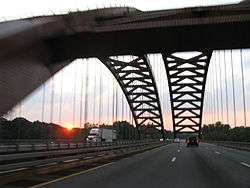
Adirondack Northway
The toll-free, six-lane Adirondack Northway bisects Saratoga County, running in a south-north direction. This highway, designated Interstate 87, is the primary conduit connecting the capital of New York State, Albany, northward across the Thaddeus Kosciusko Bridge into and through Saratoga County, then past Lake George in the Adirondack Park, through the Adirondack Mountains, and eventually to the Canada–United States border, where it continues seamlessly as Quebec Autoroute 15 to Montreal. This freeway has been a major catalyst for the growth of population and commerce in Saratoga County.
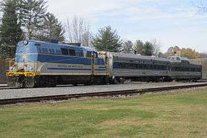
Rail
The Saratoga and North Creek Railway is a heritage railway that began operation in July 2011 and currently operates between the Saratoga Springs Amtrak station at its southern terminus and North Creek in the Adirondack Park at its northern terminus, where it connects with Amtrak's Ethan Allen Express and Adirondack services. Its commercial operations were originally built by the Adirondack Railway.
Airports
The following public-use airports are located in Saratoga County:[19]
- Saratoga County Airport (5B2) – Saratoga Springs
- Garnseys Airport (B04) – Schuylerville
- Heber Airpark (K30) – Gansevoort
- Plateau Sky Ranch Airport (1F2) – Edinburg
- Round Lake Airport (W57) – Round Lake
Economy
Tech Valley
Since the 2000s, the economy of Saratoga County and the surrounding Capital District has been redirected toward high technology. Tech Valley is a marketing name for the eastern part of New York State, encompassing Saratoga County, the Capital District, and the Hudson Valley.[20] Originated in 1998 to promote the greater Albany area as a high-tech competitor to regions such as Silicon Valley and Boston, it has since grown to represent the counties in the Capital District and extending to IBM's Westchester County plants in the south and the Canada–US border to the north. The area's high technology ecosystem is supported by technologically focused academic institutions including Rensselaer Polytechnic Institute and the State University of New York Polytechnic Institute.[6] Tech Valley encompasses 19 counties straddling both sides of the Adirondack Northway and the New York Thruway,[20] and with heavy state taxpayer subsidy, has experienced significant growth in the computer hardware side of the high-technology industry, with great strides in the nanotechnology sector, digital electronics design, and water- and electricity-dependent integrated microchip circuit manufacturing,[4] involving companies including GlobalFoundries in Malta and others.[5][6][21]
Recreation


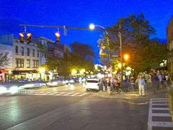
Saratoga County is extremely popular between late July and early September each year due to the Saratoga Race Course being open. This world-famous track dates back to 1863. Thoroughbred horse racing in the United States has its own Hall of Fame in Saratoga Springs, which honors remarkable horses, jockeys, owners, and trainers. Horse-racing fans come from all over to watch the races.
The Saratoga National Historical Park is located along the Hudson River in Stillwater, and features a drive-around trail where one can drive up to each station. The park is also famous for its outstanding views of the area's natural scenery and Vermont's Green Mountains in the distance.
The Saratoga Spa State Park capitalizes on the culture and the mineral springs that once drove Saratoga County. This is a large state park and includes a hotel, 2 pool complexes, mineral baths, Saratoga Performing Arts Center, picnic areas, hiking trails, and numerous mineral springs.
Saratoga County serves as the southern gateway to the Adirondack Park, the largest park in the contiguous United States, covering approximately 6.1 million acres (2.5×10⁶ ha), a land area roughly the size of Vermont and greater than the areas of the National Parks of Yellowstone, Grand Canyon, Glacier, and Great Smoky Mountains combined.[22] A portion of northwestern Saratoga County lies within the boundaries of the Adirondack Park and includes Hadley Mountain.
Communities
Cities
Towns
Villages
Census-designated places
Hamlets
Government
Saratoga County is governed by a Board Of Supervisors, with each town Supervisor acting as the representative from that community. The City of Saratoga Springs elects two Supervisors and the City of Mechanicville elects one supervisor to sit on the Board of Supervisors, but have no power in their respective city governments. The Town of Clifton Park also elects two Supervisors, one being the elected Town Supervisor, and one having only County duties. Voting is by weighted vote of each of the communities based on population, which is the reason why Saratoga Springs and Clifton Park, the two largest communities in Saratoga County, elect two Supervisors. The political makeup of the 2016-17 Board consists of 21 Republicans, and two Democrats,. By long-standing tradition, whoever serves as Chairman of the Board of Supervisor's powerful Law and Finance Committee one year serves as Chairman of the full Board the following year—a tradition that has been broken only three times in Saratoga County's history. Under this custom, current Law and Finance Committee Chairman Arthur "Mo" Wright, the Supervisor of the Town of Hadley, is slated to become Chairman of the full Board in 2016.
Republicans hold the county-wide offices of Sheriff, District Attorney, County Clerk, Treasurer, and Judges of the County, Family, and the Surrogate Courts.
Saratoga County has been a Republican-leaning county in most major elections. George W. Bush won the county narrowly in 2004 with 53% of the vote, while Barack Obama slightly edged out John McCain in 2008, receiving 51% of the vote countywide becoming the first Democrat to win Saratoga County since 1996. The county is represented in the U.S. Congress by Republican Elise Stefanik and Democrat Paul Tonko.
In the State Senate, the county is divided between Republicans Kathy Marchoine and Hugh Farley, while in the State Assembly Democrats Ronald Canestrari and Carrie Woerner, along with Republicans James Tedisco,and Dan Stec,]] each represent portions of the county.
James A. Murphy III, a Republican, is the County Court Judge and a former District Attorney.
James A. Bowen had been the dean of NYS Sheriffs, having served as Sheriff since 1972, when he was appointed by Governor Nelson A. Rockefeller. Bowen won election in his own right in 1973 and had been elected every four years up until his retirement at the end of his tenth term in office in 2013. Michael H. Zurlo is the current Sheriff, winning the election to succeed Bowen in 2013.
Democratic strength is best shown in the City of Saratoga Springs, which has voted Democratic in every presidential election since 1988. Republican strength is concentrated in the western part of the county, which is mostly rural or exurban. In 2005, the Democrats gained a majority on the Saratoga Springs City Council after decades of Republican dominance. The Republicans, however, reclaimed the council majority in the 2007 General Elections due to a split Democratic Party in the mayor's race. In 2009, the Republicans reclaimed their supermajority (4-1) on the City Council, by winning every contested election (Mayor, Finance, Public Safety, and Public Works). In 2011, Democrats reclaimed the Majority on the City Council, while Republican Scott Johnson was reelected as Mayor. The Current City Council (2016-2017)is 4-1 Democratic led by Mayor Joanne Yepsen. At the Saratoga County Board of Supervisors, the City is split, with one Republican and one Democrat holding the two Supervisor seats.
See also
- List of counties in New York
- National Register of Historic Places listings in Saratoga County, New York
References
- 1 2 3 4 5 "State & County QuickFacts - Saratoga County, New York". United States Census Bureau. Retrieved March 25, 2016.
- 1 2 "Fun Facts About Saratoga". Saratoga County Chamber of Commerce. Retrieved March 29, 2015.
- ↑ "Find a County". National Association of Counties. Retrieved March 16, 2015.
- 1 2 3 Keshia Clukey (June 27, 2014). "Better than advertised: Chip plant beats expectations". Albany Business Review. Retrieved July 20, 2015.
- 1 2 Freeman Klopott; Xu Wang & Niamh Ring (September 27, 2011). "IBM, Intel Start $4.4 Billion in Chip Venture in New York". 2011 Bloomberg. Retrieved July 12, 2015.
- 1 2 3 Larry Rulison (July 10, 2015). "Made in Albany: IBM reveals breakthrough chip made at SUNY Poly". Albany Times-Union. Retrieved July 12, 2015.
- ↑ "Fab 8 Overview". GLOBALFOUNDRIES Inc. Retrieved September 1, 2014.
- ↑ Starr, Timothy (2008). Invented in Saratoga County. New York: Rock City Falls.
- ↑ "Saratoga County, New York". Retrieved March 28, 2015.
- ↑ "2010 Census Gazetteer Files". United States Census Bureau. August 22, 2012. Retrieved January 7, 2015.
- ↑ "County Totals Dataset: Population, Population Change and Estimated Components of Population Change: April 1, 2010 to July 1, 2015". Retrieved July 2, 2016.
- ↑ "U.S. Decennial Census". United States Census Bureau. Retrieved January 7, 2015.
- ↑ "Historical Census Browser". University of Virginia Library. Retrieved January 7, 2015.
- ↑ "Population of Counties by Decennial Census: 1900 to 1990". United States Census Bureau. Retrieved January 7, 2015.
- ↑ "Census 2000 PHC-T-4. Ranking Tables for Counties: 1990 and 2000" (PDF). United States Census Bureau. Retrieved January 7, 2015.
- ↑ Population Growth. CensusScope. Retrieved on 2013-08-16.
- ↑ "Profile of General Population and Housing Characteristics: 2010 Demographic Profile Data". United States Census Bureau. Retrieved March 28, 2015.
- ↑ "State & County QuickFacts - Saratoga County, New York QuickLinks - American Community Survey: Economic Characteristics - Selected Economic Characteristics - 2009-2013 American Community Survey 5-Year Estimates". United States Census Bureau. Retrieved March 28, 2015.
- ↑ Saratoga County Public and Private Airports, New York. Retrieved June 13, 2013.
- 1 2 "About Tech Valley". Tech Valley Chamber Coalition. Retrieved 2009-09-27.
- ↑ "Fab 8 Overview". GLOBALFOUNDRIES Inc. Retrieved July 12, 2015.
- ↑ "Largest Park Area in the Contiguous US Remains Open to Visitors". Regional Office of Sustainable Tourism / Lake Placid CVB. October 3, 2013. Retrieved March 28, 2015.
Further reading
- Sylvester, Nathaniel Bartlett (1878). History of Saratoga County, New York, with illustrations biographical sketches of some of its prominent men and pioneers. Philadelphia, PA: Everts & Ensign. OCLC 3858600. Retrieved 2011-09-06.
External links
| Wikimedia Commons has media related to Saratoga County, New York. |
- Saratoga County, New York site
- Saratoga County at DMOZ
- History of Saratoga County
- Saratoga County Local Histories and Biographies
- Brookside Museum, Saratoga County Historical Society
- Saratoga County history links and information
Municipalities and communities of Saratoga County, New York, United States | ||
|---|---|---|
| Cities | | |
| Towns | ||
| Villages | ||
| CDPs | ||
| Other hamlets | ||
| Footnotes | ‡This populated place also has portions in an adjacent county or counties | |
| |||||||||||||||||||||||||||||||||||||||||||||||||||||||||||||||||||||||||||||||||||||||||||||||||
| |||||||||||||||||||||||||||||||||||||||||||||||||||||||||||||||||||||||||||||||||||||||||||||||||
Albany (capital) | ||
| Topics |
|  |
| Politics | ||
| Regions |
| |
| Metro areas | ||
| Counties |
| |
| Places | ||
Coordinates: 43°07′N 73°52′W / 43.11°N 73.87°W