Madison County, New York
| Madison County, New York | ||
|---|---|---|
| ||
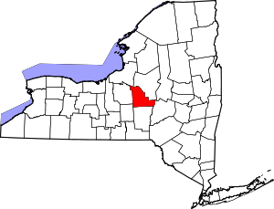 Location in the U.S. state of New York | ||
 New York's location in the U.S. | ||
| Founded | 1806 | |
| Named for | James Madison | |
| Seat | Wampsville | |
| Largest city | Oneida | |
| Area | ||
| • Total | 661 sq mi (1,712 km2) | |
| • Land | 655 sq mi (1,696 km2) | |
| • Water | 6.4 sq mi (17 km2), 1.0% | |
| Population | ||
| • (2010) | 73,442 | |
| • Density | 112/sq mi (43/km²) | |
| Congressional district | 22nd | |
| Time zone | Eastern: UTC-5/-4 | |
| Website |
www | |

Madison County is a county located in the U.S. state of New York. As of the 2010 census, the population was 73,442.[1] Its county seat is Wampsville.[2] The county is named after James Madison,[3] fourth President of the United States of America, and was first formed in 1806.
Madison County is part of the Syracuse, NY Metropolitan Statistical Area.
History
Indigenous peoples had occupied areas around Oneida Lake for thousands of years. The historic Oneida Nation is an Iroquoian-speaking people who emerged as a culture in this area about the fourteenth century and dominated the territory. They are one of the Five Nations who originally comprised the Iroquois Confederacy or Haudenosaunee.
English colonists established counties in eastern present-day New York State in 1683; at the time, the territory of the present Madison County was considered part of Albany County, with the city of Albany located on the Hudson River. This was an enormous county, including the northern part of New York State around Albany as well as all of the present State of Vermont and, in theory, extending westward to the Pacific Ocean. It was claimed by the English but largely occupied by the Oneida, Onondaga, Seneca, Cayuga and Mohawk, who had the territory in the central Mohawk Valley, as well as Mahican near the Hudson River. On July 3, 1766 the English organized Cumberland County, and on March 16, 1770 they organized Gloucester County, both containing territory now included in the state of Vermont.

On March 12, 1772, what was left of Albany County was split into three parts, one remaining under the name Albany County. One of the other pieces, Tryon County, contained the western portion (and thus, since no western boundary was specified, theoretically still extended west to the Pacific). The eastern boundary of Tryon County was approximately five miles west of the present city of Schenectady, and the county included the western part of the Adirondack Mountains and the area west of the West Branch of the Delaware River. The area then designated as Tryon County includes 37 current counties of New York State. The county was named for William Tryon, the colonial governor of New York.
In the years prior to the outbreak of revolution in 1776, tensions rose in the frontier areas upstate and most of the Loyalists in Tryon County fled to Canada. In 1784, following the peace treaty that ended the American Revolutionary War, New York changed the name of Tryon County to Montgomery County, in honor of the general, Richard Montgomery, who had captured several places in Canada and died attempting to capture the city of Quebec.
As allies of the Patriots, the Oneida Nation was allocated land by the United States in the postwar settlement for a reservation near Oneida Lake, in their traditional homeland. In the postwar treaty, the four Iroquois nations who had been allies of the British were forced to cede their lands; most of their peoples had already migrated to Canada to escape the worst of the fighting on the frontier after Sullivan's Raid. This expedition through Indian country had destroyed dwellings, crops and winter stores; many Iroquois who did not migrate died of starvation that winter.
But settlers were hungry for land, and in 1788 Governor Clinton's representatives persuaded the Oneida to cede some of their territory to the state for sale to European-American settlers. This was called the "Clinton Purchase", after Governor George Clinton. The land comprised the southern portion of the Oneida reservation. It has also been called the Twenty Townships, as these were the number organized after New York controlled the land.
As this sale was never ratified by the United States Senate, it was declared unconstitutional in a ruling by the United States Supreme Court in the late twentieth century.[4] New York State had no legal authority after the Revolution and the formation of the United States to negotiate separately with American Indian tribes.
In 1789, Montgomery County was reduced in size by the splitting off of Ontario County. This was later divided to form the present Allegany, Cattaraugus, Chautauqua, Erie, Genesee, Livingston, Monroe, Niagara, Orleans, Steuben, Wyoming, Yates, and part of Schuyler and Wayne counties.
In 1791, Herkimer and Tioga counties were two of three counties split off from Montgomery County (the other being Otsego County).
Chenango County was formed in 1798 from parts of Tioga and Herkimer counties. Finally, Madison County was created from Chenango County in 1806.
About 1802, the Oneida agreed to allocate about 22,000 acres of their land to the Stockbridge and Munsee (Lenape), who were seeking refuge from anti-Native American conflicts by American settlers after the Revolution. Both were Christianized: the Stockbridge had migrated from western Massachusetts and the Lenape from New York and New Jersey. The two peoples were pressured to leave New York for Wisconsin in the 1820s, to make more land available for European-American settlement.
In the late twentieth century, the three recognized Oneida tribes: of Wisconsin, New York, and the Thames reserve in Canada, filed suit in a land claim against New York State for its treaty and forced purchase of their ancestral lands after the American Revolutionary War, seeking return of thousands of acres. The US Supreme Court has ruled the purchase was unconstitutional, as New York did not have the treaty ratified by the US Senate, and had no authority under the US Constitution to deal directly with the Oneida, a right reserved to the federal government. In 2010 the state offered the Oneida Tribe of Wisconsin more than 300 acres in Sullivan County in the Catskill Mountains, with permission to construct a gambling casino, and 2 acres in Madison County, to settle their part of the suit. Several private and public interests oppose the deal, including other federally recognized tribes in New York.
Geography
According to the U.S. Census Bureau, the county has a total area of 661 square miles (1,710 km2), of which 655 square miles (1,700 km2) is land and 6.4 square miles (17 km2) (1.0%) is water.[5]
Madison County is located in central New York State, just east of Syracuse, north of Binghamton, and slightly north of due west from Albany. Madison County contains the geographic center of the state at Pratts Hollow in the Town of Eaton.
Oneida Lake and Oneida Creek define part of the northern boundary. The Great Swamp, formerly located south of the lake, was a rich wetlands habitat important to many species of birds and wildlife. This was drained by local and state construction projects in the early decades of the twentieth century, chiefly by Italian immigrants. The fertile soil supported high production of onions and other commodity crops, and the Italian families grew wealthy from their work. The area was known as "Black Beach" for its mucklands.[6] Chittenango Creek defines much of the western boundary.
Adjacent counties and areas
Chenango County is across the southern border. Onondaga and Cortland counties form the western border, with Onondaga serving as Madison County's longest and most prominent border. Otsego County forms a short boundary in the southeast corner of Madison County. Oneida County shares a northeast border with Madison County. Oneida Lake is the northern border with part of Oswego County on the opposite shore.
Demographics
| Historical population | |||
|---|---|---|---|
| Census | Pop. | %± | |
| 1810 | 25,144 | — | |
| 1820 | 32,208 | 28.1% | |
| 1830 | 39,038 | 21.2% | |
| 1840 | 40,008 | 2.5% | |
| 1850 | 43,072 | 7.7% | |
| 1860 | 43,545 | 1.1% | |
| 1870 | 43,522 | −0.1% | |
| 1880 | 44,112 | 1.4% | |
| 1890 | 42,892 | −2.8% | |
| 1900 | 40,545 | −5.5% | |
| 1910 | 39,289 | −3.1% | |
| 1920 | 39,535 | 0.6% | |
| 1930 | 39,790 | 0.6% | |
| 1940 | 39,598 | −0.5% | |
| 1950 | 46,214 | 16.7% | |
| 1960 | 54,635 | 18.2% | |
| 1970 | 62,864 | 15.1% | |
| 1980 | 65,150 | 3.6% | |
| 1990 | 69,120 | 6.1% | |
| 2000 | 69,441 | 0.5% | |
| 2010 | 73,442 | 5.8% | |
| Est. 2015 | 71,849 | [7] | −2.2% |
| U.S. Decennial Census[8] 1790-1960[9] 1900-1990[10] 1990-2000[11] 2010-2013[1] | |||
As of the census[12] of 2000, there were 69,441 people, 25,368 households, and 17,580 families residing in the county. The population density was 106 people per square mile (41/km²). There were 28,646 housing units at an average density of 44 per square mile (17/km²). The racial makeup of the county was 96.49% White, 1.32% African American, 0.52% Native American, 0.56% Asian, 0.01% Pacific Islander, 0.26% from other races, and 0.84% from two or more races. Hispanic or Latino of any race were 1.06% of the population; 16.1% were of German, 15.6% English, 15.5% Irish, 12.1% Italian, and 8.0% American ancestry according to Census 2000. Of these 95.6% spoke English and 1.9% Spanish as their first language.
There were 25,368 households out of which 33.60% had children under the age of 18 living with them, 55.10% were married couples living together, 9.70% had a female householder with no husband present, and 30.70% were non-families. Of all households 24.50% were made up of individuals and 10.30% had someone living alone who was 65 years of age or older. The average household size was 2.55 and the average family size was 3.04.
In the county the population was spread out with 24.90% under the age of 18, 12.00% from 18 to 24, 27.60% from 25 to 44, 23.00% from 45 to 64, and 12.50% who were 65 years of age or older. The median age was 36 years. For every 100 females there were 96.30 males. For every 100 females age 18 and over, there were 93.80 males.
The median income for a household in the county was $40,184, and the median income for a family was $47,889. Males had a median income of $33,069 versus $25,026 for females. The per capita income for the county was $19,105. About 6.30% of families and 9.80% of the population were below the poverty line, including 10.50% of those under age 18 and 8.80% of those age 65 or over.
Much of Madison County is rural. However, Oneida and the other towns along NY Route 5 are suburbs of Syracuse, as is Cazenovia.
Education
School districts
- Brookfield Central School District
- Canastota Central School District
- Cazenovia Central School District
- Chittenango Central School District
- DeRuyter Central School
- Hamilton Central School District
- Madison Central School District
- Morrisville-Eaton Central School District
- Oneida City School District
- Stockbridge Valley Central School District
Colleges and universities
Communities
City
Towns
The towns in southern Madison County originated from the Twenty Townships ceded by the Oneida tribe to the State of New York.
Villages
- Canastota
- Cazenovia
- Chittenango
- DeRuyter
- Earlville
- Hamilton
- Madison
- Morrisville
- Munnsville
- Wampsville (county seat)
Census-designated place
Hamlets
See also
- List of counties in New York
- National Register of Historic Places listings in Madison County, New York
References
- 1 2 "State & County QuickFacts". United States Census Bureau. Retrieved October 12, 2013.
- ↑ "Find a County". National Association of Counties. Retrieved 2011-06-07.
- ↑ Gannett, Henry (1905). The Origin of Certain Place Names in the United States. U.S. Government Printing Office. p. 196.
- ↑ County Of Oneida v. Oneida Indian Nation, 470 U.S. 226 (1985)
- ↑ "2010 Census Gazetteer Files". United States Census Bureau. August 22, 2012. Retrieved January 5, 2015.
- ↑ Barbagallo, Tricia (June 1, 2005). "Black Beach: The Mucklands of Canastota, New York" (PDF). New York Archives. Retrieved 2008-06-04.
- ↑ "County Totals Dataset: Population, Population Change and Estimated Components of Population Change: April 1, 2010 to July 1, 2015". Retrieved July 2, 2016.
- ↑ "U.S. Decennial Census". United States Census Bureau. Retrieved January 5, 2015.
- ↑ "Historical Census Browser". University of Virginia Library. Retrieved January 5, 2015.
- ↑ "Population of Counties by Decennial Census: 1900 to 1990". United States Census Bureau. Retrieved January 5, 2015.
- ↑ "Census 2000 PHC-T-4. Ranking Tables for Counties: 1990 and 2000" (PDF). United States Census Bureau. Retrieved January 5, 2015.
- ↑ "American FactFinder". United States Census Bureau. Retrieved 2008-01-31.
External links
| Wikimedia Commons has media related to Madison County, New York. |
- Information on hotels, B&B's, Country Inns and attractions in Madison County
- A guide to the culinary escapades of Madison County, NY
- Barbagallo, Tricia (June 1, 2005). "Black Beach: The Mucklands of Canastota, New York" (PDF). Retrieved 2008-06-04.
- Madison County, NY
- Madison County at DMOZ
- Early Madison County history
- Historical summaries of Madison County history, maps, photos
 |
Oswego County | Oneida County | | |
| Onondaga County | |
|||
| ||||
| | ||||
| Cortland County | Chenango County | Otsego County |
Municipalities and communities of Madison County, New York, United States | ||
|---|---|---|
| City | | |
| Towns | ||
| Villages | ||
| CDP | ||
| Other hamlets | ||
| Indian reservations | ||
| Footnotes | ‡This populated place also has portions in another county or counties | |
Coordinates: 42°55′N 75°40′W / 42.91°N 75.67°W