Chemung County, New York
| Chemung County, New York | ||
|---|---|---|
| County | ||
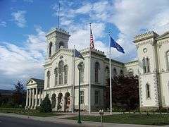 Chemung County Courthouse | ||
| ||
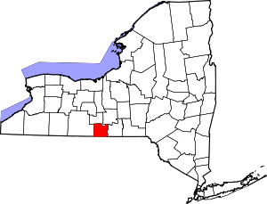 Location in the U.S. state of New York | ||
 New York's location in the U.S. | ||
| Founded | March 29, 1836 | |
| Seat | Elmira | |
| Largest city | Elmira | |
| Area | ||
| • Total | 411 sq mi (1,064 km2) | |
| • Land | 407 sq mi (1,054 km2) | |
| • Water | 3.4 sq mi (9 km2), 0.8% | |
| Population | ||
| • (2010) | 88,830 | |
| • Density | 218/sq mi (84/km²) | |
| Congressional district | 23rd | |
| Time zone | Eastern: UTC-5/-4 | |
| Website |
www | |

Chemung County is a county in the southern tier of the U.S. state of New York. As of the 2010 census, the population was 88,830.[1] Its county seat is Elmira.[2] Its name is derived from a Delaware Indian village whose name meant "big horn".
Chemung County comprises the Elmira, NY Metropolitan Statistical Area, which is also included in the Elmira-Corning, NY Combined Statistical Area.
Many signs posted along roads in Chemung County refer to the area as "Mark Twain Country," because the noted author lived and wrote for many years in Elmira.
History
For the history of Chemung County prior to its creation by partition, see Tioga County, New York.
Chemung County was formed from 520 square miles (1,300 km2) of Tioga County in 1836.[3]
In 1854, Chemung County was divided and 110 square miles (280 km2) became Schuyler County, reducing Chemung to 410 square miles (1,100 km2), its current size.[4]
In the late 1870s, the Greenbacker Party became prominent in Chemung and nearby counties in western New York. Here it was primarily allied with labor in a critique of capital, reaching its peak in 1878, the year following the Great Railroad Strike of 1877 and the Scranton General Strike in Pennsylvania. There were also strikes that year in Albany, Syracuse and Buffalo, starting with the railroad workers. In Steuben and Chemung counties, Greenbackers were elected to county councils in 1878 instead of Democrats, and others were elected from there and nearby counties to the state legislature, gaining votes of more than 25 percent in several of the Southern Tier counties. It gradually declined after that, due to internal dissension and the strength of the two major parties.[5]
Geography
According to the U.S. Census Bureau, the county has a total area of 411 square miles (1,060 km2), of which 407 square miles (1,050 km2) is land and 3.4 square miles (8.8 km2) (0.8%) is water.[6]
Chemung County is in the southwestern part of New York State, along the Pennsylvania border, in a part of New York called the Southern Tier and is also part of the Finger Lakes Region.
The Southern Tier Expressway runs through the County east-west near the Pennsylvania border, between Waverly, New York and Corning, New York via Elmira, New York.
Adjacent counties
- Schuyler County - north
- Tompkins County - northeast
- Tioga County - east
- Bradford County, Pennsylvania - south
- Tioga County, Pennsylvania - southwest
- Steuben County - west
Transportation
Major highways
-
 Interstate 86 (Southern Tier Expressway)
 -
 New York State Route 13
 -
 New York State Route 14
 -
 New York State Route 17 (Southern Tier Expressway)
 -
 New York State Route 34
 -
 New York State Route 223
 -
 New York State Route 328
 -
 New York State Route 352
 -
 New York State Route 367
 -
 New York State Route 414
 -
 New York State Route 427
Airport
Demographics
| Historical population | |||
|---|---|---|---|
| Census | Pop. | %± | |
| 1840 | 20,732 | — | |
| 1850 | 28,821 | 39.0% | |
| 1860 | 26,917 | −6.6% | |
| 1870 | 35,281 | 31.1% | |
| 1880 | 43,065 | 22.1% | |
| 1890 | 48,265 | 12.1% | |
| 1900 | 54,063 | 12.0% | |
| 1910 | 54,662 | 1.1% | |
| 1920 | 65,872 | 20.5% | |
| 1930 | 74,680 | 13.4% | |
| 1940 | 73,718 | −1.3% | |
| 1950 | 86,827 | 17.8% | |
| 1960 | 98,706 | 13.7% | |
| 1970 | 101,537 | 2.9% | |
| 1980 | 97,656 | −3.8% | |
| 1990 | 95,195 | −2.5% | |
| 2000 | 91,070 | −4.3% | |
| 2010 | 88,830 | −2.5% | |
| Est. 2015 | 87,071 | [7] | −2.0% |
| U.S. Decennial Census[8] 1790-1960[9] 1900-1990[10] 1990-2000[11] 2010-2013[1] | |||
At of the 2000 census,[12] there were 91,070 people, 35,049 households and 23,272 families residing in the county. The population density was 223 per square mile (86/km²). There were 37,745 housing units at an average density of 92 per square mile (36/km²). The racial makeup of the county was 90.96% White, 5.82% Black or African American, 0.23% Native American, 0.78% Asian, 0.02% Pacific Islander, 0.75% from other races, and 1.44% from two or more races. 1.77% of the population were Hispanic or Latino of any race. 16.4% were of German, 15.7% Irish, 12.5% English, 11.8% Italian, 7.8% American and 6.3% Polish ancestry according to Census 2000 . Most of those claiming to be of "American" ancestry are of English descent and, in upstate New York, also in some cases of Dutch descent, but have family that has been in the country for so long, in many cases since the early seventeenth century, that they choose to identify simply as "American".[13][14][15][16][17] 96.2% spoke English and 1.6% Spanish as their first language.
There were 35,049 households of which 31.00% had children under the age of 18 living with them, 49.80% were married couples living together, 12.40% had a female householder with no husband present, and 33.60% were non-families. 27.90% of all households were made up of individuals and 12.20% had someone living alone who was 65 years of age or older. The average household size was 2.44 and the average family size was 2.97.
Age distribution was 24.40% under the age of 18, 8.80% from 18 to 24, 28.30% from 25 to 44, 22.90% from 45 to 64, and 15.60% who were 65 years of age or older. The median age was 38 years. For every 100 females there were 97.70 males. For every 100 females age 18 and over, there were 95.30 males.
The median household income was $36,415, and the median family income was $43,994. Males had a median income of $35,076 versus $24,215 for females. The per capita income for the county was $18,264. About 9.10% of families and 13.00% of the population were below the poverty line, including 18.40% of those under age 18 and 6.80% of those age 65 or over.
Government and politics
Before 1974, Chemung County was governed by a board of supervisors. On January 1, 1974, executive and legislative powers were split between a county executive and a 15-seat legislature.[18] All 15 members are elected from single-member districts.
| Name | Party | Term |
|---|---|---|
| John H. Hazlett | Republican | January 1, 1974 – 1975 |
| Morris E. Blostein | Republican | 1975–1979 |
| Stanley Benjamin | Republican | 1979–1983 |
| Robert G. Densberger | Republican | 1983–1991 |
| G. Thomas Tranter, Jr. | Republican | 1991–2000 |
| Thomas J. Santulli | Republican | 2000 – |
In presidential elections Chemung County tends to vote Republican. It voted for George W. Bush in 2004 by a 10.85% margin. In 2008 the margin was much closer, but voters still gave John McCain a 1.23% win over Barack Obama. In 2012 Mitt Romney carried the county by 2.33%.
Education
Education in Chemung County is provided by various private and public institutions. High school students and adults have access to GST BOCES.[19] BOCES provides vocation-style training in a wide range of fields as well as adult education.
Public school districts
- Horseheads Central School District
- Elmira City School District
- Elmira Heights Central School District[20]
Private schools
- Chemung Valley Montessori School[21]
- Elmira Christian Academy[22]
- Holy Family Middle School[23]
- Saint Mary Our Mother School[24]
- Notre Dame High School[25]
- Twin Tiers Christian Academy[26]
Higher education
- Arnot Ogden School of Nursing[27]
- Corning Community College[28] (off-campus sites)
- Elmira College
- Elmira Business Institute[29]
Public libraries
Chemung County Library District
- Steele Memorial Library
- Horseheads Free Library
- Big Flats Library
- West Elmira Library
- Van Etten Library
- Chemung County Bookmobile[30]
Communities
City
- Elmira (county seat)
Towns
Villages
Census-designated places
Hamlet
See also
- List of counties in New York
- National Register of Historic Places listings in Chemung County, New York
References
- New York: Atlas of Historical County Boundaries; Compiled by Kathryn Ford Thorne and Edited by John H. Long.
- 1 2 "State & County QuickFacts". United States Census Bureau. Retrieved October 11, 2013.
- ↑ "Find a County". National Association of Counties. Archived from the original on 2011-05-31. Retrieved 2011-06-07.
- ↑ New York. Laws of New York.1836, 59th Session, Chapter 077, Section 1, Page 102.
- ↑ New York. Laws of New York.1854, 77th Session, Chapter 386, Sections 1—4 & 6, Pages 913—915.
- ↑ Milton M. Klein, The Empire State: A History of New York, Ithaca, New York: Cornell University Press, 2005, pp. 455-456
- ↑ "2010 Census Gazetteer Files". United States Census Bureau. August 22, 2012. Retrieved January 3, 2015.
- ↑ "County Totals Dataset: Population, Population Change and Estimated Components of Population Change: April 1, 2010 to July 1, 2015". Retrieved July 2, 2016.
- ↑ "U.S. Decennial Census". United States Census Bureau. Archived from the original on May 11, 2015. Retrieved January 3, 2015.
- ↑ "Historical Census Browser". University of Virginia Library. Retrieved January 3, 2015.
- ↑ "Population of Counties by Decennial Census: 1900 to 1990". United States Census Bureau. Retrieved January 3, 2015.
- ↑ "Census 2000 PHC-T-4. Ranking Tables for Counties: 1990 and 2000" (PDF). United States Census Bureau. Retrieved January 3, 2015.
- ↑ "American FactFinder". United States Census Bureau. Archived from the original on 2013-09-11. Retrieved 2008-01-31.
- ↑ Sharing the Dream: White Males in a Multicultural America By Dominic J. Pulera.
- ↑ Reynolds Farley, "The New Census Question about Ancestry: What Did It Tell Us?", Demography, Vol. 28, No. 3 (August 1991), pp. 414, 421.
- ↑ Stanley Lieberson and Lawrence Santi, 'The Use of Nativity Data to Estimate Ethnic Characteristics and Patterns', Social Science Research, Vol. 14, No. 1 (1985), pp. 44-6.
- ↑ Stanley Lieberson and Mary C. Waters, 'Ethnic Groups in Flux: The Changing Ethnic Responses of American Whites', Annals of the American Academy of Political and Social Science, Vol. 487, No. 79 (September 1986), pp. 82-86.
- ↑ Mary C. Waters, Ethnic Options: Choosing Identities in America (Berkeley: University of California Press, 1990), p. 36.
- ↑ "3 MORE COUNTIES ADOPT CHARTERS", The New York Times, New York, New York, p. 59, 1973-11-25
- ↑ "About GST BOCES Bush Campus". GST BOCES. Retrieved 8 May 2013.
- ↑ "Chemung County New York School Districts". NewYorkSchools.com. Retrieved 8 May 2013.
- ↑ "Chemung Valley Montessori School". Go Montessori. Retrieved 8 May 2013.
- ↑ "Elmira Christian Academy". Elmira Christian Academy. Retrieved 8 May 2013.
- ↑ "Welcome-Holy Family Junior High School (Elmira)". Diocese of Rochester. Retrieved 8 May 2013.
- ↑ "Welcome-St. Mary Our Mother School". Diocese of Rochester. Retrieved 8 May 2013.
- ↑ "Notre Dame High School". Notre Dame High School. Retrieved 8 May 2013.
- ↑ "Twin Tiers Christian Academy Home". Twin Tiers Christian Academy. Retrieved 7 Nov 2014.
- ↑ "Arnot Health". Arnot Health. Retrieved 8 May 2013.
- ↑ "Corning Community College Facilities". Corning Community College. Retrieved 8 May 2013.
- ↑ "Medical and Technical Career Training Programs - EBI Career Institute". Elmira Business Institute. Retrieved 8 May 2013.
- ↑ "Our Libraries". Chemung County Library District. Retrieved 8 May 2013.
External links
| Wikivoyage has a travel guide for Chemung County. |
- Chemung County, New York site
- Chemung County Chamber of Commerce
- Early brief history of Chemung County
- Elmira College
- Chemung County Library District
- Chemung County at DMOZ
- Matthias Hollenback, Revolutionary War soldier, merchant in early Elmira, judge
 |
Schuyler County | Tompkins County | | |
| Steuben County | |
Tioga County | ||
| ||||
| | ||||
| Tioga County, Pennsylvania | Bradford County, Pennsylvania |
Municipalities and communities of Chemung County, New York, United States | ||
|---|---|---|
| City | | |
| Towns | ||
| Villages | ||
| CDPs | ||
| Hamlets | ||
Coordinates: 42°08′N 76°46′W / 42.14°N 76.76°W