Jordan, New York
| Jordan, New York | |
|---|---|
| Village | |
|
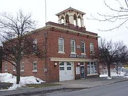
Jordan Village Hall, December 2008 | |
 Location in Onondaga County and the state of New York. | |
| Coordinates: 43°4′N 76°28′W / 43.067°N 76.467°WCoordinates: 43°4′N 76°28′W / 43.067°N 76.467°W | |
| Country | United States |
| State | New York |
| County | Onondaga |
| Town | Elbridge |
| Area | |
| • Total | 1.2 sq mi (3.0 km2) |
| • Land | 1.2 sq mi (3.0 km2) |
| • Water | 0.0 sq mi (0.0 km2) |
| Elevation | 413 ft (126 m) |
| Population (2010) | |
| • Total | 1,368 |
| Time zone | Eastern (EST) (UTC-5) |
| • Summer (DST) | EDT (UTC-4) |
| ZIP code | 13080 |
| Area code(s) | 315 |
| FIPS code | 36-38825 |
| GNIS feature ID | 0954196 |
| Website |
www |
Jordan is a village in Onondaga County, New York, United States. The population was 1,368 at the 2010 census. It is part of the Syracuse Metropolitan Statistical Area. It was named from the Jordan River.[1]
Jordan is located in the northwest part of the town of Elbridge, west of Syracuse.
History
The village bloomed with the opening of the Erie Canal in 1825. Due to the canal, Jordan became larger than Elbridge Village, farther south.
Jordan became an incorporated village in 1835.
In 1983, much of the village was included in the Jordan Village Historic District and listed on the National Register of Historic Places.[2]
Lincoln funeral procession
On April 25, 1865, Abraham Lincoln's black-draped funeral train slowed for the crowd lining the New York Central Railroad tracks at the Erie Canal on the way west to Springfield, Illinois.[3] As the train passed through, some men on furlough from the 3rd New York Artillery Division fired a cannon salute from the nearby canal. They had made arrangements with local farmer, Isaac C. Otis, whose "land straddled" Skaneateles Creek just north of the canal, to shoot at a large elm tree on the east side of the creek. Their aim was true, and a 6-pound (2.7 kg) cannonball hit the tree about 20 feet (6.1 m) off the ground, burying itself about 18-inch (460 mm) into the trunk. The tree, which was cut down in the 1930s, was referred to as the "cannonball tree" although no one knew the tale was true until the tree was chopped down and "there it was." The cannonball, about the size of a softball and still embedded in wood from the tree, is displayed at the Jordan Museum, a storehouse of artifacts kept in a room in the rear of the Bramley Library building.[3]
Erie Canal
When the Erie Canal first began construction on July 4, 1817, construction started in Rome, New York. Lock 51 in Jordan was built around 1818 to 1824; the canal opened in October 1825. The Erie Canal was active until 1918, when it was closed.
Historic places and businesses
The Jordan Lodge 386 F. & A.M., also known as the Masonic building, is located in Jordan on North Main Street. It was built in 1979. Bush Funeral Home, established in 1904, is also located on North Main Street.
Image gallery
 Erie Canal Lock 51 historical building
 Hardware store built in 1898, converted into the Jordan Post Office in the 1970s
 Teen Center & Ceramic Shop, with apartments on second floor
 Front/side view of Teen Center
 Jordan Lodge 386 F. & A.M.
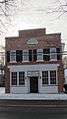 Bush Funeral Home
 Old Jordan Laundry Mat, Old Pizza's Sam's, Jordan Bank LNB
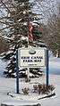 Erie Canal Park-Way
 Tree City USA sign, Arborday Foundation
 "Jordan National Historic District" sign, Clinton St.
Geography
Jordan is located at 43°4′N 76°28′W / 43.067°N 76.467°W (43.0658, -76.4729).[4]
According to the United States Census Bureau, the village has a total area of 1.2 square miles (3.1 km2), all of it land.
The village was formerly located on the Erie Canal, which has been re-routed farther north. The New York State Thruway (Interstate 90) passes north of the village, but there is no interchange at all in the town.
Skaneateles Creek flows through the village. The Jordan Aqueduct still stands where the Erie Canal crossed Skaneateles Creek.
Jordan is by the junction of New York State Route 31 and New York State Route 317.
Demographics
| Historical population | |||
|---|---|---|---|
| Census | Pop. | %± | |
| 1860 | 1,488 | — | |
| 1870 | 1,263 | −15.1% | |
| 1880 | 1,344 | 6.4% | |
| 1890 | 1,271 | −5.4% | |
| 1900 | 1,118 | −12.0% | |
| 1910 | 978 | −12.5% | |
| 1920 | 1,012 | 3.5% | |
| 1930 | 1,145 | 13.1% | |
| 1940 | 1,115 | −2.6% | |
| 1950 | 1,295 | 16.1% | |
| 1960 | 1,300 | 0.4% | |
| 1970 | 1,493 | 14.8% | |
| 1980 | 1,371 | −8.2% | |
| 1990 | 1,325 | −3.4% | |
| 2000 | 1,314 | −0.8% | |
| 2010 | 1,368 | 4.1% | |
| Est. 2015 | 1,333 | [5] | −2.6% |
As of the census[7] of 2000, there were 1,314 people, 499 households, and 336 families residing in the village. The population density was 1,136.7 people per square mile (437.4/km²). There were 542 housing units at an average density of 468.9 per square mile (180.4/km²). The racial makeup of the village was 97.34% White, 0.46% African American, 0.61% Native American, 0.53% Asian, 0.38% from other races, and 0.68% from two or more races. Hispanic or Latino of any race were 1.07% of the population.
There were 499 households out of which 41.5% had children under the age of 18 living with them, 48.7% were married couples living together, 13.2% had a female householder with no husband present, and 32.5% were non-families. 28.5% of all households were made up of individuals and 15.8% had someone living alone who was 65 years of age or older. The average household size was 2.63 and the average family size was 3.25.
In the village the population was spread out with 32.0% under the age of 18, 6.7% from 18 to 24, 28.5% from 25 to 44, 19.4% from 45 to 64, and 13.5% who were 65 years of age or older. The median age was 35 years. For every 100 females there were 96.1 males. For every 100 females age 18 and over, there were 89.0 males.
The median income for a household in the village was $34,728, and the median income for a family was $40,234. Males had a median income of $32,583 versus $26,250 for females. The per capita income for the village was $15,844. About 6.3% of families and 8.5% of the population were below the poverty line, including 9.4% of those under age 18 and 13.0% of those age 65 or over.
References
- ↑ Gannett, Henry (1905). The Origin of Certain Place Names in the United States. Govt. Print. Off. p. 171.
- ↑ National Park Service (2009-03-13). "National Register Information System". National Register of Historic Places. National Park Service.
- 1 2 Grau, John (October 23, 1997 pg.D6). "Students keep Lincoln legend alive". Syracuse Herald-Journal. Syracuse, New York. Check date values in:
|date=(help) - ↑ "US Gazetteer files: 2010, 2000, and 1990". United States Census Bureau. 2011-02-12. Retrieved 2011-04-23.
- ↑ "Annual Estimates of the Resident Population for Incorporated Places: April 1, 2010 to July 1, 2015". Retrieved July 2, 2016.
- ↑ "Census of Population and Housing". Census.gov. Retrieved June 4, 2015.
- ↑ "American FactFinder". United States Census Bureau. Retrieved 2008-01-31.
External links
- Village of Jordan official website
- The Eagle Observer, weekly newspaper
- New York State Rural Water Information
- Jordan Big M Article
Municipalities and communities of Onondaga County, New York, United States | ||
|---|---|---|
| City | 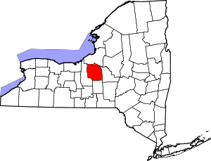 | |
| Towns | ||
| Villages | ||
| CDPs | ||
| Other hamlets |
| |
| Indian reservation | ||
| Footnotes | ‡This populated place also has portions in an adjacent county or counties | |