Livingston County, New York
| Livingston County, New York | ||
|---|---|---|
 Livingston County Courthouse | ||
| ||
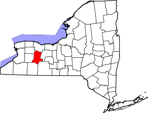 Location in the U.S. state of New York | ||
 New York's location in the U.S. | ||
| Founded | 1821 | |
| Named for | Robert R. Livingston | |
| Seat | Geneseo | |
| Largest town | Geneseo | |
| Area | ||
| • Total | 640 sq mi (1,658 km2) | |
| • Land | 632 sq mi (1,637 km2) | |
| • Water | 8.5 sq mi (22 km2), 1.3% | |
| Population | ||
| • (2010) | 65,393 | |
| • Density | 104/sq mi (40/km²) | |
| Congressional district | 27th | |
| Time zone | Eastern: UTC-5/-4 | |
| Website |
www | |

Livingston County is a county in the U.S. state of New York. As of the 2010 census, the population was 65,393.[1] Its county seat is Geneseo.[2] The county is named after Robert R. Livingston, a member of the committee that drafted the Declaration of Independence.
Livingston County is part of the Rochester Metropolitan Statistical Area.
History
When counties were established in New York State in 1683, the present Livingston County was part of Albany County. This was an enormous county, including the northern part of New York State as well as all of the present State of Vermont and, in theory, extending westward to the Pacific Ocean. This county was reduced in size on July 3, 1766 by the creation of Cumberland County, and further on March 16, 1770 by the creation of Gloucester County, both containing territory now in Vermont.
On March 12, 1772, what was left of Albany County was split into three parts, one remaining under the name Albany County. One of the other pieces, Tryon County, contained the western portion (and thus, since no western boundary was specified, theoretically still extended west to the Pacific). The eastern boundary of Tryon County was approximately five miles west of the present city of Schenectady, and the county included the western part of the Adirondack Mountains and the area west of the West Branch of the Delaware River. The area then designated as Tryon County now includes 37 counties of New York State. The county was named for William Tryon, colonial governor of New York.
In the years prior to 1776, most of the Loyalists in Tryon County fled to Canada. In 1784, following the peace treaty that ended the American Revolutionary War, the name of Tryon County was changed to Montgomery County in order to honor the general, Richard Montgomery, who had captured several places in Canada and died attempting to capture the city of Quebec, replacing the name of the hated British governor.
In 1789, Ontario County was split off from Montgomery. The actual area split off from Montgomery County was much larger than the present county, also including the present Allegany, Cattaraugus, Chautauqua, Erie, Genesee, Livingston, Monroe, Niagara, Orleans, Steuben, Wyoming, Yates, and part of Schuyler and Wayne Counties.
Genesee County was created by a splitting of Ontario County in 1802. This was much larger than the present Genesee County, however. It contained the present Allegany, Cattaraugus, Chautauqua, Erie, Niagara, Orleans, Wyoming, and portions of Livingston and Monroe Counties.
Livingston County was formed from Genesee and Ontario Counties in 1821.
Livingston County is home to the State University of New York, College at Geneseo (now SUNY Geneseo)
Geography
According to the U.S. Census Bureau, the county has a total area of 640 square miles (1,700 km2), of which 632 square miles (1,640 km2) is land and 8.5 square miles (22 km2) (1.3%) is water.[3]
Livingston County is located in the Finger Lakes region, south of Rochester and east of Buffalo.
Letchworth State Park in partly in the western part of the county. The Genesee River flows northward through the county.
The Rochester and Southern Railroad (RSR) traverses the county from Greigsville south through Mount Morris to Dansville.
Adjacent counties
- Monroe County - north
- Ontario County - east
- Steuben County - southeast
- Allegany County - south
- Wyoming County - west
- Genesee County - northwest
Major highways
Government and politics
Livingston County is governed by a 17–member legislature headed by a chairman.
Representation at other levels of government
| Office | District | Area of the county | Officeholder | Party | First took office | Residence |
|---|---|---|---|---|---|---|
| Congressman | New York's 27th congressional district | All[4] | Christopher C. Collins | Republican | 2013 | Clarence, Erie County |
| State Senator | 57th State Senate District | Conesus, Livonia, Mount Morris, North Dansville, Nunda, Ossian, Sparta, Springwater[5] | Catharine M. Young | Republican | 2005 | Olean, Cattaraugus County |
| State Senator | 59th State Senate District | Avon, Caledonia, Geneseo, Groveland, Leicester, Lima, West Sparta, York[6] | Patrick M. Gallivan | Republican | 2011 | Elma, Erie County |
| State Assemblyman | 133rd State Assembly District | All except Leicester and York[7] | Vacant | |||
| State Assemblyman | 139th State Assembly District | Leicester and York[8] | Stephen M. Hawley | Republican | 2006 | Batavia, Genesee County |
Livingston County is part of:
- The 7th Judicial District of the New York Supreme Court
- The 4th Division of the New York Supreme Court, Appellate Division
Demographics
| Historical population | |||
|---|---|---|---|
| Census | Pop. | %± | |
| 1830 | 27,729 | — | |
| 1840 | 35,140 | 26.7% | |
| 1850 | 40,875 | 16.3% | |
| 1860 | 39,546 | −3.3% | |
| 1870 | 39,309 | −0.6% | |
| 1880 | 39,562 | 0.6% | |
| 1890 | 37,801 | −4.5% | |
| 1900 | 37,059 | −2.0% | |
| 1910 | 38,037 | 2.6% | |
| 1920 | 36,830 | −3.2% | |
| 1930 | 37,560 | 2.0% | |
| 1940 | 38,510 | 2.5% | |
| 1950 | 40,257 | 4.5% | |
| 1960 | 44,053 | 9.4% | |
| 1970 | 54,041 | 22.7% | |
| 1980 | 57,006 | 5.5% | |
| 1990 | 62,372 | 9.4% | |
| 2000 | 64,328 | 3.1% | |
| 2010 | 65,393 | 1.7% | |
| Est. 2015 | 64,717 | [9] | −1.0% |
| U.S. Decennial Census[10] 1790-1960[11] 1900-1990[12] 1990-2000[13] 2010-2013[1] | |||
As of the census[14] of 2000, there were 64,328 people, 22,150 households, and 15,349 families residing in the county. The population density was 102 people per square mile (39/km²). There were 24,023 housing units at an average density of 38 per square mile (15/km²). The racial makeup of the county was 94.04% White, 3.01% African American, 0.27% Native American, 0.76% Asian, 0.03% Pacific Islander, 0.85% from other races, and 1.04% from two or more races. Hispanic or Latino of any race were 2.27% of the population. 22.5% were of German, 17.7% Irish, 14.3% Italian, 12.8% English and 7.0% American ancestry according to Census 2000. 95.8% spoke English and 2.0% Spanish as their first language.
There were 22,150 households out of which 34.00% had children under the age of 18 living with them, 54.80% were married couples living together, 10.00% had a female householder with no husband present, and 30.70% were non-families. 23.10% of all households were made up of individuals and 9.40% had someone living alone who was 65 years of age or older. The average household size was 2.60 and the average family size was 3.05.
In the county the population was spread out with 23.40% under the age of 18, 14.20% from 18 to 24, 28.90% from 25 to 44, 22.10% from 45 to 64, and 11.40% who were 65 years of age or older. The median age was 35 years. For every 100 females there were 100.70 males. For every 100 females age 18 and over, there were 99.00 males.
The median income for a household in the county was $42,066, and the median income for a family was $50,513. Males had a median income of $36,599 versus $25,228 for females. The per capita income for the county was $18,062. About 5.80% of families and 10.40% of the population were below the poverty line, including 9.70% of those under age 18 and 6.50% of those age 65 or over.
Communities
Towns
Villages
Census-designated places
Hamlet
Notable people
- Cassius McDonald Barnes, American Civil War soldier, served as the 4th Governor of Oklahoma Territory; born in Livingston.[15]
- Clinton Bowen Fisk, American Civil War brigadier general, banker, 1888 US Presidential candidate for the Prohibition Party, and person whom Fisk University is named; born in York.[16]
- Henry I. Weed, Wisconsin state senator and lawyer, was born in Livingston County.[17]
See also
- Livingston County Courthouse (New York)
- List of counties in New York
- National Register of Historic Places listings in Livingston County, New York
References
- 1 2 "State & County QuickFacts". United States Census Bureau. Retrieved October 12, 2013.
- ↑ "Find a County". National Association of Counties. Retrieved 2011-06-07.
- ↑ "2010 Census Gazetteer Files". United States Census Bureau. August 22, 2012. Retrieved January 5, 2015.
- ↑ W, Eric (2012-04-02). "Congressional District 27" (PDF). View 2012 Congressional Maps. Albany, New York: The New York State Legislative Task Force on Demographic Research and Reapportionment. Retrieved 2013-01-13.
- ↑ W, Eric (2012-03-02). "Senate District 57" (PDF). View 2012 Senate District Maps. Albany, New York: The New York State Legislative Task Force on Demographic Research and Reapportionment. Retrieved 2013-01-06.
- ↑ W, Eric (2012-03-02). "Senate District 59" (PDF). View 2012 Senate District Maps. Albany, New York: The New York State Legislative Task Force on Demographic Research and Reapportionment. Retrieved 2013-01-06.
- ↑ W, Eric (2012-01-25). "Assembly District 133" (PDF). View Proposed 2012 Assembly District Maps. Albany, New York: The New York State Legislative Task Force on Demographic Research and Reapportionment. Retrieved 2013-01-06.
- ↑ W, Eric (2012-01-25). "Assembly District 139" (PDF). View Proposed 2012 Assembly District Maps. Albany, New York: The New York State Legislative Task Force on Demographic Research and Reapportionment. Retrieved 2013-01-13.
- ↑ "County Totals Dataset: Population, Population Change and Estimated Components of Population Change: April 1, 2010 to July 1, 2015". Retrieved July 2, 2016.
- ↑ "U.S. Decennial Census". United States Census Bureau. Retrieved January 5, 2015.
- ↑ "Historical Census Browser". University of Virginia Library. Retrieved January 5, 2015.
- ↑ "Population of Counties by Decennial Census: 1900 to 1990". United States Census Bureau. Retrieved January 5, 2015.
- ↑ "Census 2000 PHC-T-4. Ranking Tables for Counties: 1990 and 2000" (PDF). United States Census Bureau. Retrieved January 5, 2015.
- ↑ "American FactFinder". United States Census Bureau. Retrieved 2008-01-31.
- ↑ "Cassius McDonald Barnes". Find A Grave. Retrieved September 19, 2012.
- ↑ "Clinton Bowen Fisk". Find A Grave. Retrieved May 11, 2015.
- ↑ 'Wisconsin Blue Book 1901,' Biographical Sketch of Henry Irwin Weed, pg. 734-735
External links
| Wikimedia Commons has media related to Livingston County, New York. |
- Livingston County webpage
- Information from the Chamber of Commerce
- Livingston County at DMOZ
- Brief histories of Livingston towns
- Summary history of Livingston County and its towns
 |
Genesee County | Monroe County | Monroe County | |
| Wyoming County | |
Ontario County | ||
| ||||
| | ||||
| Allegany County | Allegany County | Steuben County |
Municipalities and communities of Livingston County, New York, United States | ||
|---|---|---|
| Towns | | |
| Villages | ||
| CDPs |
| |
| Other hamlet | ||
Coordinates: 42°44′N 77°46′W / 42.73°N 77.77°W