Interstate 81 in New York
| ||||
|---|---|---|---|---|
|
Map of New York with I-81 highlighted in red | ||||
| Route information | ||||
| Maintained by NYSDOT and the Thousand Islands Bridge Authority | ||||
| Length: | 183.62 mi[1] (295.51 km) | |||
| Existed: | August 14, 1957[2] – present | |||
| Major junctions | ||||
| South end: |
| |||
|
| ||||
| North end: |
| |||
| Highway system | ||||
| ||||

_map.svg.png)
Interstate 81 (I-81) is a part of the Interstate Highway System that runs from Interstate 40 at Dandridge, Tennessee, to the Thousand Islands International Bridge at Wellesley Island in New York, beyond which a short stub links it to Ontario Highway 401. In the U.S. state of New York, I-81 extends 183.62 miles (295.51 km) from the Pennsylvania state line southeast of Binghamton to the Canadian border at Wellesley Island northwest of Alexandria Bay. The freeway runs north–south through Central New York, serving the cities of Binghamton, Syracuse, and Watertown. It passes through the Thousand Islands in its final miles and crosses two bridges, both part of the series of bridges known as the Thousand Islands Bridge.
South of Watertown, I-81 closely parallels U.S. Route 11 (US 11), the main north–south highway in Central New York prior to the construction of I-81. At Watertown, US 11 turns northeastward to head across New York's North Country while I-81 continues on a generally northward track to the Canadian border. From there, the road continues into the province of Ontario as Highway 137, a short route leading north to the nearby Highway 401.
The portion of I-81 in New York was originally developed as the Penn-Can Highway, one of four expressways proposed by the state in 1953. It was added to the Interstate Highway System and designated I-81 in 1957, and constructed in sections over the course of the next decade. The first segment was completed in the mid-1950s, running from Tully to the southern edge of Syracuse. The last piece opened in the late 1960s, linking Marathon to Whitney Point.
Route description
Southern Tier
I-81 crosses the New York–Pennsylvania border about 11 miles (18 km) southeast of the city of Binghamton. The freeway heads northwest from the state line, running through a valley surrounding the Susquehanna River in the town of Kirkwood. This stretch of I-81 closely parallels US 11, continuing a trend that originally began at I-81's southern terminus in eastern Tennessee. Both roads head across relatively undeveloped areas along the eastern riverbank to the outskirts of Binghamton, where I-81 merges with New York State Route 17 (NY 17) in an industrial area east of the city. I-81 and NY 17 overlap for 5 miles (8 km), running along the northern edge of the Binghamton suburbs before entering the city itself. About 1.5 miles (2.4 km) north of downtown, the freeway connects to Brandywine Highway, a limited-access road carrying NY 7 through mostly residential areas on the north side of the city.[3]


Just west of the Brandywine Highway junction, I-81 and NY 17 cross the Chenango River as they split at a directional T interchange[3] comprising part of an S-curve in NY 17 known locally as Kamikaze Curve.[5] While NY 17 heads west into the curve, I-81 proceeds northward along the west bank of the river, connecting to US 11 and passing by Broome Community College on its way into the suburban town of Chenango. Here, I-81 meets the western terminus of I-88 at a junction roughly 3 miles (4.8 km) north of Binghamton. Continuing on, the freeway intersects US 11 a second time before leaving the banks of the Susquehanna River and proceeding generally northwestward into increasingly rural areas of the Southern Tier. The route makes its way across a series of hills and valleys for 13 miles (21 km) to the village of Whitney Point, connecting to US 11 and two state routes of regional importance—NY 26 and NY 79—at two exits on the western edge of the community.[3]
Continuing on, I-81 begins to follow the Tioughnioga River, a tributary of the Susquehanna, as it bypasses the nearby village of Lisle to the east. While US 11 runs across the base of a valley flanking the river, the freeway proceeds along the valley's eastern edge, overlooking the valley road on its way to the Broome–Cortland county line. Both routes cross the border at points just yards apart, beginning their transition from the Southern Tier region to Central New York. About 2 miles (3.2 km) from the county line, I-81 encounters the village of Marathon, situated inside the river valley at the junction of US 11 and NY 221. The freeway connects to the latter at an interchange just east of the village center before heading northwestward for 11 miles (18 km) across a series of moraines in another prolonged rural stretch. Along the way, I-81 passes between the Tuller Hill and Hoxie Gorge state forests, located near Messengerville on the western and eastern sides of the highway, respectively.[3]
Cortland to Syracuse
The rural, northwestward trend ends west of the village of McGraw at a junction with NY 41, the primary east–west (signed north-south) road through the community. NY 41 continues west from the exit for a short distance to meet US 11, and the two routes become concurrent for the next 5 miles (8.0 km). I-81, US 11, and NY 41 all head westward from this point, passing a handful of scattered businesses to reach the eastern edge of the nearby city of Cortland. While US 11 and NY 41 continue directly into the city, I-81 bypasses it to the northeast. As such, it crosses only moderately developed areas on the periphery of Cortland. The road connects to downtown Cortland by way of an exit with NY 13, a north–south route serving most of Central New York. Near the exit, the Tioughnioga River splits into two branches, with NY 13 following the east branch to the northeast and I-81 proceeding westward along the west branch.[3]
North of downtown Cortland, I-81 makes a 90-degree turn to the north, matching a similar curve in the course of the nearby river. This track brings the freeway to the suburban village of Homer, which I-81 connects to via exit 12. The trumpet interchange feeds into a long east–west ramp linking the highway to the parallel US 11, NY 41 and NY 281, another parallel road farther west. NY 41 leaves US 11 in Homer, and I-81, US 11, and NY 281 proceed slightly northeastward across a low-lying, undeveloped area in an otherwise hilly region of Cortland County. Just south of the Onondaga County line, I-81 directly meets NY 281 as it crosses from the western side of the freeway to the eastern edge. They meet one final time across the county line near the village of Tully, where NY 281 ends as I-81 intersects NY 80 and NY 11A. The west branch of the Tioughnioga River also terminates here, flowing into Tully Lake at the county line.[3]
The amount of development along the freeway slowly increases as it heads north through the county. In La Fayette, I-81 meets with US 20, one of a handful of east–west roads spanning the width of the state. Continuing on, I-81 and US 11 pass east of the Onondaga Indian Reservation, connecting once again at exit 16 before entering the city of Syracuse. At this point, the forests that had lined both roads give way to the dense residential neighborhoods that comprise the city's southern half. Roughly 3 miles (4.8 km) south of downtown Syracuse, I-81 meets with I-481, an alternate route of I-81 bypassing the city to the east. I-81 itself proceeds due north toward downtown on an embankment, running alongside the New York, Susquehanna and Western Railway (NYSW) and passing adjacent to Oakwood Cemetery. The surrounding area transitions from mostly residential to mostly commercial at the north edge of the cemetery, where I-81 passes west of the campuses of Syracuse University and SUNY-ESF.[3]
Syracuse and Oswego County
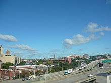
West of Syracuse University, the NYSW turns west to pass under I-81. At this point, the embankment gives way to an elevated highway carrying I-81 through downtown.[3] The road separates the 15th Ward on its west side from Syracuse University and the area's hospitals on its east side; it also visually hangs over the predominantly residential 15th Ward.[6] Farther north, the density of the commercial districts adjacent to the highway continue to increase as the road enters downtown Syracuse. For roughly a half-mile (0.8 km), I-81 heads east–west, running alongside I-690 and connecting to the highway by way of a series of closely spaced ramps. Like I-81, the incomplete interchange is entirely elevated, passing over parts of several downtown blocks. Past I-690, I-81 transitions from an elevated road to a sub-surface highway as it cuts across the north half of downtown and proceeds northwest past an old industrial area that was once Syracuse's Inner Harbor.[3] The elevated portion in Syracuse is expected to reach the end of its useful life in 2017.[7]
The cut eventually brings the freeway to the southeastern tip of Onondaga Lake, where I-81 ascends in elevation once again at a network of interchanges with NY 370 and a handful of nearby streets. The series of junctions serve Destiny USA, the area's largest mall; NBT Bank Stadium, the home of the Syracuse Chiefs; and the William F. Walsh Regional Transportation Center (RTC), Syracuse's bus and train station. I-81 subsequently passes over CSX Transportation's Mohawk Subdivision rail line, which serves the RTC. North of the rail overpass, the road finally returns to ground level as it heads northeastward through Syracuse's residential northern suburbs. In Salina, I-81 meets the New York State Thruway (I-90) at exit 25A and connects to Syracuse Hancock International Airport at exit 27. About 6 miles (9.7 km) north of downtown, the highway enters the village of North Syracuse, where I-481 rejoins I-81 at exit 29.[3]
While I-481 continues northwest from North Syracuse as NY 481, I-81 travels north through residential areas of gradually decreasing density. Just north of the junction with I-481 and NY 481, the freeway passes east of the former Penn-Can Mall, the largest commercial parcel in the area. I-81's first junction north of Syracuse is in the town of Cicero, where it connects to NY 31, another regionally important highway. North of here, US 11 begins to closely parallel I-81 once again, rejoining the highway's vicinity after following an erratic alignment through Syracuse. The two roads run across relatively flat and increasingly undeveloped land to Brewerton, a hamlet adjacent to where Oneida Lake empties into the Oneida River. While US 11 runs through the community, I-81 bypasses it to the east, offering unobstructed views of the lake as it crosses the lake outlet and enters Oswego County.[3]
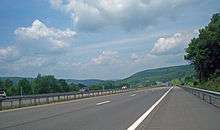
On the opposite riverbank, I-81 initially runs past a line of lakefront houses and cottages; however, it soon enters a large marshy area named Big Bay Swamp. The wetlands reach as far north as Central Square, a village just west of I-81's interchange with NY 49. For most of the next 13 miles (21 km), I-81 runs north across a mixture of swamps and fields, both undeveloped and fairly level in elevation. Along this stretch, the freeway links to two more major routes: NY 69 and NY 104. The highway eventually reaches the village of Pulaski, where it reconnects to NY 13 at a partial interchange east of the village center. From here to Watertown, I-81 loosely parallels Lake Ontario, located about 7 miles (11 km) to the west and more closely followed by NY 3. Another substantial stretch of open, rolling fields brings the route to Sandy Creek, where it connects to County Route 15 (CR 15),[3] a highway designated NY 288 during the 1930s.[8][9]
North Country
Past Sandy Creek, I-81 proceeds into Jefferson County, where it continues to travel across rural, undeveloped areas with only gentle elevation changes. US 11 crosses I-81 for the last time just north of the county line, connecting to the freeway and switching from the highway's west side to its east side. As a result, I-81 now passes west of several villages and large hamlets, all located directly on US 11. Connections to the communities are made by the primary east–west highways serving them, namely CR 90 for Mannsville; NY 193 for Pierrepont Manor; NY 178 for Adams; and NY 177 for Adams Center. At Adams Center, both I-81 and US 11 take on a more northeasterly routing, bringing them farther inland toward the city of Watertown. The final exit before the city itself leads to NY 232, a short connector between I-81 and Watertown Center, the southern extent of Watertown's suburbs.[3]
The rural surroundings finally end, albeit briefly, in the vicinity of Watertown, where I-81 intersects NY 3 in a commercialized area west of downtown Watertown. All four corners of the junction contain at least one shopping plaza, and the northwestern corner features the sprawling Salmon Run Mall. The commercial development follows I-81 north to its next exit, a diamond interchange with NY 12F near Jefferson Community College. At this point, I-81 turns northeastward, running south of an industrial park and north of the college before crossing the Black River to meet NY 12 in a less developed but still commercialized area north of the city. US 11 and I-81 finally part ways at this point, with I-81 continuing north toward Canada and US 11 heading northeast to serve some of the North Country's northernmost communities.[3]
As the highway leaves the Watertown area, it passes into another area of rolling, open terrain with only pockets of development in the immediate vicinity of the road's interchanges. NY 37 largely replaces US 11 as the paralleling surface route, and the state route follows I-81 for 13 miles (21 km) to the vicinity of Theresa. West of the village, I-81 intersects NY 411, a connector between La Fargeville and NY 37. While NY 37 continues north from Theresa, I-81 turns to the northwest, crossing increasingly isolated areas of the state to reach NY 12 on the south shore of the St. Lawrence River midway between Clayton and Alexandria Bay. From here, the freeway heads into the Thousand Islands on the first of several bridges known collectively as the Thousand Islands Bridge.[3]
In the Thousand Islands, I-81 runs across Wellesley Island, one of the archipelago's largest. It initially heads northwest across the sparsely developed island, connecting to a pair of county-maintained roads before turning northeast at the eastern edge of Wellesley Island State Park. The freeway turns one final time near the northern edge of the island, curving back to the northwest at exit 52, the last exit along I-81. For most of its run on the island, I-81 runs along or close to the island's edge, permitting views of the river and some of the area's other islands. Not far from exit 52, an interchange linking the freeway to a paralleling local road, I-81 crosses the International Rift on a 90-foot (27 m) bridge connecting Wellesley Island in New York to Hill Island in Ontario, Canada. From here, the road continues north to Highway 401 as Highway 137. The long, continuous bridge span between Wellesley Island and the United States mainland is one of the few remaining two-lane stretches left on the Interstate Highway System.[3]
History
The Binghamton–Syracuse–Watertown corridor was originally served by NY 2, a route assigned as part of the creation of the modern New York state route system in 1924.[10] It was replaced by US 11 when U.S. Highways were first posted in New York in 1927.[11] In February 1953, New York Governor Thomas Dewey proposed constructing four expressways across the state of New York to supplement the then-under construction New York State Thruway. One of the four proposed highways closely followed US 11, beginning in Binghamton and proceeding generally northward through Central New York to the Canadian border north of Watertown.[12] A connection to the Pennsylvania state line was eventually added to the route, which became known as the Penn-Can Highway.[13] On August 14, 1957, the Penn-Can Highway was included in the Interstate Highway System and designated as part of I-81.[2]
In the mid-1950s, the first section of the highway was completed, connecting Tully (modern exit 14) to Nedrow (16), just south of Syracuse.[14][15] Another section, extending from North Syracuse (26) to Brewerton (31), was opened to traffic in the late 1950s.[15][16] In the North Country, the first completed section ran from Adams (41) to Pamelia (48); it was put into service on October 21, 1959.[17] Extensions of the North Syracuse–Brewerton segment south into downtown Syracuse (19) and north to Parish (33) were completed c. 1961.[16][18] The section between modern exits 38 and 41 in southern Jefferson County was finished in November 1961, and the gap between the Syracuse–Parish and Jefferson County segments was filled on December 1, 1961, creating a continuous limited-access highway between Syracuse and Watertown.[17]
I-81 was opened to traffic from the Pennsylvania state line north to NY 17 in Kirkwood in mid-1961,[18][19] and the piece linking Pamelia to the Canadian border was completed on September 29, 1965.[17] Three more sections of I-81 were finished to traffic in the mid-1960s, completing all of I-81 within the state except for the portion between NY 221 in Marathon and NY 26 in Whitney Point.[20][21] The Marathon–Whitney Point segment was completed c. 1968.[21][22] In Syracuse, part of I-81 was built on an elevated highway, intended to make travel from downtown Syracuse to Syracuse University faster.[23]
Future
The section of I-81 that runs through Syracuse is slowly deteriorating and is due to be reconstructed.[23] The New York State Department of Transportation (NYSDOT) has frequently said that I-81 will need to be changed due to its deteriorating condition.[24] One major reason for the urgency of this effort is the condition of the elevated highway and other bridges located on I-81 between the I-481 interchanges on opposite sides of the city, as well as on I-690 in the vicinity of I-81's interchange with the highway.[23] In 2001, Syracuse Common Councillor Van Robinson called for the removal of some elevated portions of I-81 that were blocking Upstate Medical University. He stated that the bridge not only presented a problem sectionalizing the Syracuse area, but also it presented a problem for Syracuse University and Upstate Medical University.[25]
The region is set to reach a final decision on the future of I-81 with input from many local groups, or stakeholders. In early May 2011, this official process was started by two entities: NYSDOT and the Syracuse Metropolitan Transportation Council (SMTC), the region’s metropolitan planning organization. NYSDOT is responsible for overseeing the process and, eventually, its construction. SMTC consists of member agencies that have a stake in transportation decisions in Central New York.[26] Both parties have yet to reach a decision, but they hope to eventually reach one that is in the best interest for everyone in the greater Syracuse area. In late March 2011, SMTC and NYSDOT announced the formation of the I-81 Community Liaison Committee (CLC). The CLC is made up of representatives from 37 organizations and will give ideas and point out concerns about the future of I-81 in Syracuse.[27]
Exit list
Unlike in other states, exit numbers in New York are roughly sequential.
| County | Location[1] | mi[1] | km | Exit | Destinations | Notes |
|---|---|---|---|---|---|---|
| Broome | Kirkwood | 0.00 | 0.00 | – | Continuation from Pennsylvania | |
| 3.98 | 6.41 | 1 | ||||
| 8.08– 8.66 | 13.00– 13.94 | 2E | No exit number southbound; southern end of concurrency with NY 17 & Future I-86; temporary western terminus of I-86; Exit 75 on I-86 | |||
| 8.08 | 13.00 | 2W | Northbound signage | |||
| 8.51 | 13.70 | 2 | Southbound signage | |||
| 8.90 | 14.32 | 3 | Colesville Road – Industrial Park | Southbound exit and northbound entrance | ||
| Binghamton | 12.17 | 19.59 | 3 | Broad Avenue | Northbound exit and southbound entrance | |
| 12.55 | 20.20 | 4N | ||||
| 4S | ||||||
| 13.05 | 21.00 | Northern end of concurrency with NY 17 & Future I-86; Future I-86 west; Eastern terminus of Southern Tier Expressway | ||||
| Dickinson | 13.72 | 22.08 | 5 | I-88 east only appears on southbound signage | ||
| Chenango | 14.78 | 23.79 | No exit southbound | |||
| 15.83– 16.62 | 25.48– 26.75 | 6 | To I-88 only appears on southbound signage | |||
| 21.62 | 34.79 | 7 | ||||
| Barker | 28.99 | 46.65 | 8 | Northbound exit and southbound entrance | ||
| Triangle | 30.38 | 48.89 | Southbound exit and northbound entrance | |||
| Cortland | Village of Marathon | 38.27 | 61.59 | 9 | ||
| Cortlandville | 50.02 | 80.50 | 10 | |||
| Cortland | 52.36 | 84.27 | 11 | Ithaca only appears on southbound signage; access to SUNY Cortland | ||
| Cortlandville | 54.09 | 87.05 | 12 | NY 41 and Cortland only appears on southbound signage | ||
| Preble | 62.89 | 101.21 | 13 | |||
| Onondaga | Tully | 66.62 | 107.21 | 14 | ||
| LaFayette | 73.22 | 117.84 | 15 | Northbound signage | ||
| Southbound signage | ||||||
| Onondaga | 78.13 | 125.74 | 16 | |||
| Syracuse | 81.51 | 131.18 | 16A | Left exit southbound | ||
| 82.48 | 132.74 | 17 | South State Street / South Salina Street / Brighton Avenue | South State Street only appears on southbound signage; access to Carrier Dome | ||
| 84.07 | 135.30 | 18 | Adams Street / Harrison Street | Access to Oncenter and Syracuse University | ||
| 84.71 | 136.33 | |||||
| Northbound exit and southbound entrance | ||||||
| 19 | Clinton Street / Salina Street | Southbound exit and northbound entrance | ||||
| 20 | Franklin Street / West Street | Southbound exit and northbound entrance | ||||
| 21 | Spencer Street / Catawba Street | Southbound exit and entrance | ||||
| 86.23 | 138.77 | 22 | Northbound signage | |||
| Southbound signage | ||||||
| 23A | Hiawatha Boulevard | Southbound exit only; access to bus & train station, NBT Bank Stadium, and Regional Market | ||||
| 23B | Destiny USA Drive | Southbound exit only | ||||
| 86.90 | 139.85 | 23 | Northbound exit only; access to Destiny USA, NBT Bank Stadium, and Regional Market | |||
| 24A | Old Liverpool Road – Liverpool | Northbound exit and southbound entrance | ||||
| 24B | ||||||
| Salina | 25 | 7th North Street – Liverpool | ||||
| 88.30 | 142.11 | 25A | Exit 36 on I-90 | |||
| 89.85 | 144.60 | 26 | ||||
| 90.46 | 145.58 | 27 | Combined with Exit 28 northbound and Exit 26 southbound | |||
| Cicero | 91.28 | 146.90 | 28 | Taft Road – North Syracuse | ||
| 92.69 | 149.17 | 29S | Exit 9 on I-481 / NY 481 | |||
| 29N | ||||||
| 95.11 | 153.06 | 30 | ||||
| 99.08 | 159.45 | 31 | Bartell Road to | |||
| Oneida Lake | 99.30 | 159.81 | Onondaga–Oswego county line | |||
| Oswego | Hastings | 102.93 | 165.65 | 32 | ||
| Parish | 111.19 | 178.94 | 33 | |||
| 114.92 | 184.95 | 34 | ||||
| Richland | 118.35 | 190.47 | 35 | Tinker Tavern Road to | ||
| Pulaski | 121.73 | 195.91 | 36 | Northbound exit and southbound entrance | ||
| 122.54 | 197.21 | Southbound exit and northbound entrance | ||||
| Village of Sandy Creek | 128.15 | 206.24 | 37 | Northbound exit and southbound entrance | ||
| 128.31 | 206.49 | Southbound exit and northbound entrance | ||||
| Jefferson | Ellisburg | 130.85 | 210.58 | 38 | ||
| 132.89 | 213.87 | 39 | ||||
| 133.65 | 215.09 | Parking area | ||||
| 134.74 | 216.84 | 40 | ||||
| Village of Adams | 140.29 | 225.77 | 41 | |||
| Adams | 144.41 | 232.41 | 42 | |||
| 145.96 | 234.90 | 43 | ||||
| Town of Watertown | 148.34 | 238.73 | 44 | |||
| 152.67 | 245.70 | 45 | ||||
| 153.61 | 247.21 | 46 | Access to Dexter and Cape Vincent | |||
| Pamelia | 155.12 | 249.64 | 47 | |||
| 156.23 | 251.43 | Parking area | ||||
| 157.72 | 253.83 | 48 | ||||
| 48A | Exit 1 on I-781 | |||||
| Theresa | 169.25 | 272.38 | 49 | |||
| Alexandria | 178.14 | 286.69 | 50N | |||
| 50S | ||||||
| Orleans | 178.42 | 287.14 | Toll booths ($2.75 toll northbound, southbound toll is on Canadian span)[28] | |||
| US span of Thousand Islands Bridge over St. Lawrence River | ||||||
| 179.74 | 289.26 | 51 | Island Road – Island State Parks | |||
| 183.12 | 294.70 | 52 | Island Road – De Wolf Point | |||
| 183.62 | 295.51 | – | Continuation into Ontario at the Canada–United States border | |||
1.000 mi = 1.609 km; 1.000 km = 0.621 mi
| ||||||
See also
.svg.png) New York Roads portal
New York Roads portal
References
- 1 2 3 Office of Technical Services (2014). "Inventory Listing". Engineering Division, New York State Department of Transportation. Retrieved July 22, 2015.
- 1 2 Official Route Numbering for the National System of Interstate and Defense Highways (Map). American Association of State Highway Officials. August 14, 1957.
- 1 2 3 4 5 6 7 8 9 10 11 12 13 14 15 16 Google (April 16, 2012). "overview map of I-81 in New York" (Map). Google Maps. Google. Retrieved April 16, 2012.
- ↑ "Broome Gateway Center". Taste NY. New York State. Retrieved 18 August 2016.
- ↑ Zick, John (February 19, 2012). "I-86 work still far behind schedule". Corning Leader. Retrieved April 16, 2012.
Just west of the I-81 and I-88 junctions in the Binghamton area lies Prospect Mountain and 'Kamikaze Curve,' a near-90-degree turn coming down a hill.
- ↑ Baik, Galster, Jeong, and Seokgi (December 11, 2007). The Current Problems of Interstate 81 Through Downtown of Syracuse and Their Effective Solutions (PDF). Onondaga Citizens League. Retrieved April 4, 2011.
- ↑ Crawford, Amy. "The Future of Urban Freeways Is Playing Out Right Now in Syracuse". The Atlantic Cities. Atlantic Media. Retrieved 18 February 2014.
- ↑ Road Map of New York (Map). Cartography by General Drafting. Standard Oil Company of New York. 1930.
- ↑ Map of New York (Map). Cartography by H.M. Gousha Company. Shell Oil Company. 1940.
- ↑ "New York's Main Highways Designated by Numbers". The New York Times. December 21, 1924. p. XX9.
- ↑ Automobile Blue Book. 1 (1927 ed.). Chicago: Automobile Blue Book, Inc. 1927. This edition shows U.S. Routes as they were first officially signed in 1927.
- ↑ Dales, Douglas (June 20, 1954). "Across The Map; Limited-Access Highways Spreading Rapidly from Maine to the Midwest". The New York Times. pp. XX21.
- ↑ "Penn-Can Road Vital to Broome, Majority at Hearing Says" (PDF). The Binghamton Press. January 9, 1957. p. 3. Retrieved April 17, 2012.
- ↑ New York with Special Maps of Putnam–Rockland–Westchester Counties and Finger Lakes Region (Map) (1957 ed.). Cartography by General Drafting. Esso. 1956.
- 1 2 New York with Special Maps of Putnam–Rockland–Westchester Counties and Finger Lakes Region (Map) (1958 ed.). Cartography by General Drafting. Esso. 1958.
- 1 2 New York and New Jersey Tourgide Map (Map). Cartography by Rand McNally and Company. Gulf Oil Company. 1960.
- 1 2 3 "Route 81—Nearly Eight" (PDF). Watertown Daily Times. August 11, 1967. p. 4. Retrieved April 17, 2012.
- 1 2 New York and Metropolitan New York (Map) (1961–62 ed.). Cartography by H.M. Gousha Company. Sunoco. 1961.
- ↑ New York with Sight-Seeing Guide (Map) (1962 ed.). Cartography by General Drafting. Esso. 1962.
- ↑ New York and Metropolitan New York (Map). Cartography by Rand McNally and Company. Sinclair Oil Corporation. 1964.
- 1 2 Gousha Road Atlas (Map). H.M. Gousha Company. 1967. Retrieved May 10, 2010.
- ↑ New York (Map) (1969–70 ed.). Cartography by General Drafting. Esso. 1968.
- 1 2 3 The Post-Standard Editorial Board (May 14, 2010). "Tear Down I-81?" (Editorial). The Post-Standard. Syracuse, NY. Retrieved April 4, 2011.
- ↑ The I-81 Challenge. "What's New". Syracuse Metropolitan Transportation Council. Retrieved April 4, 2011.
- ↑ Mariani, John (August 11, 2008). "What should happen to Interstate-81?". The Post-Standard. Syracuse, NY. Retrieved April 7, 2011.
- ↑ The I-81 Challenge (February 2011). "The I-81 Challenge: A Brief Transportation Overview" (PDF). Syracuse Metropolitan Transportation Council. Retrieved April 5, 2011.
- ↑ Reinhardt, Eric (March 22, 2011). "Transportation council, DOT announce I-81 committee". The Greater Binghamton Business Journal. Binghamton, NY: CNY Business Review. Retrieved April 4, 2011.
- ↑ "Thousand Islands Bridge" (PDF). Thousand Islands Bridge Authority. Retrieved Jan 1, 2013.
External links
| Wikimedia Commons has media related to Interstate 81 in New York. |
- Interstate 81 at Alps' Roads • New York Routes • Upstate New York Roads
- The I-81 Challenge website
| Previous state: Pennsylvania |
New York | Next state: Terminus |