Delaware County, New York
| Delaware County, New York | ||
|---|---|---|
| County | ||
| Delaware County | ||
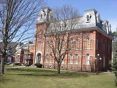 Delaware County Courthouse | ||
| ||
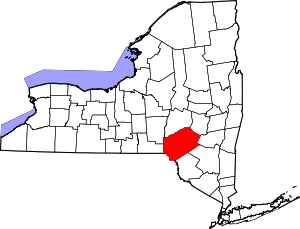 Location in the U.S. state of New York | ||
 New York's location in the U.S. | ||
| Founded | 1797 | |
| Named for | Delaware River | |
| Seat | Delhi | |
| Largest town | Sidney | |
| Area | ||
| • Total | 1,467 sq mi (3,800 km2) | |
| • Land | 1,442 sq mi (3,735 km2) | |
| • Water | 25 sq mi (65 km2), 1.7% | |
| Population | ||
| • (2010) | 47,980 | |
| • Density | 33/sq mi (13/km²) | |
| Time zone | Eastern: UTC-5/-4 | |
| Website |
www | |

Delaware County is a county located in the US state of New York. As of 2010 the population was 47,980.[1] The county seat is Delhi.[2] The county is named after the Delaware River, which was named in honor of Thomas West, 3rd Baron De La Warr, appointed governor of Virginia in 1609.
History
When counties were established in New York State in 1683, the present area of Delaware County was divided between Albany and Ulster Counties.
Albany County was an enormous county, including the northern part of New York State as well as all of the present State of Vermont and, in theory, extending westward to the Pacific Ocean. This county was reduced in size on July 3, 1766 by the creation of Cumberland County, and further on March 16, 1770 by the creation of Gloucester County, both containing territory now in Vermont. On March 12, 1772, what was left of Albany County was split into three parts, one remaining under the name Albany County. One of the other pieces, Tryon County, contained the western portion (and thus, since no western boundary was specified, theoretically still extended west to the Pacific). The eastern boundary of Tryon County was approximately five miles west of the present city of Schenectady, and the county included the western part of the Adirondack Mountains and the area west of the West Branch of the Delaware River. The area then designated as Tryon County now includes 37 counties of New York State. The county was named for William Tryon, colonial governor of New York.
In the years prior to 1776, most of the Loyalists in Tryon County fled to Canada. In 1784, following the peace treaty that ended the American Revolutionary War, the name of Tryon County was changed to Montgomery County to honor the general, Richard Montgomery, who had captured several places in Canada and died attempting to capture the city of Quebec, replacing the name of the hated British governor.
In 1789, Montgomery County was reduced in size by the splitting off of Ontario County. The actual area split off from Montgomery County was much larger than the present county, also including the present Allegany, Cattaraugus, Chautauqua, Erie, Genesee, Livingston, Monroe, Niagara, Orleans, Steuben, Wyoming, Yates, and part of Schuyler and Wayne Counties.
In 1791, Otsego was one of three counties that were split off from Montgomery (the other two being Herkimer and Tioga Counties).
Ulster County was an original county of New York State, considerably larger than the present Ulster County, and at the time that Delaware County was created it still contained most of its original area.
Delaware County was formed in 1797 by combining portions of Otsego and Ulster counties.
Geography
According to the U.S. Census Bureau, the county has a total area of 1,467 square miles (3,800 km2), of which 1,442 square miles (3,730 km2) is land and 25 square miles (65 km2) (1.7%) is water.[3] It is the fifth-largest county in New York by land area.
Delaware County is located in the southern part of the state, separated from the state of Pennsylvania by the Delaware River. It is east of Binghamton and southwest of Albany. The county contains part of the Catskill Mountains. The county is within a region called the Southern Tier of New York State.
The highest point is an approximately 3,520-foot (1,073 m) summit of Bearpen Mountain along the Greene County line. The lowest point is along the Delaware River. The county is drained by the headwaters of the Delaware. It has a hilly surface, and the soil in the valleys is exceedingly fertile. The Delaware and Susquehanna rivers are here navigable by boats.[4]
Adjacent counties
- Otsego County – north
- Schoharie County – northeast
- Greene County – east
- Ulster County – southeast
- Sullivan County – south
- Wayne County, Pennsylvania – southwest
- Broome County – west
- Chenango County – northwest
National protected area
Demographics
| Historical population | |||
|---|---|---|---|
| Census | Pop. | %± | |
| 1800 | 10,228 | — | |
| 1810 | 20,303 | 98.5% | |
| 1820 | 26,587 | 31.0% | |
| 1830 | 33,024 | 24.2% | |
| 1840 | 35,396 | 7.2% | |
| 1850 | 39,834 | 12.5% | |
| 1860 | 42,465 | 6.6% | |
| 1870 | 42,972 | 1.2% | |
| 1880 | 42,721 | −0.6% | |
| 1890 | 45,496 | 6.5% | |
| 1900 | 46,413 | 2.0% | |
| 1910 | 45,575 | −1.8% | |
| 1920 | 42,774 | −6.1% | |
| 1930 | 41,163 | −3.8% | |
| 1940 | 40,989 | −0.4% | |
| 1950 | 44,420 | 8.4% | |
| 1960 | 43,540 | −2.0% | |
| 1970 | 44,718 | 2.7% | |
| 1980 | 46,824 | 4.7% | |
| 1990 | 47,225 | 0.9% | |
| 2000 | 48,055 | 1.8% | |
| 2010 | 47,980 | −0.2% | |
| Est. 2015 | 46,053 | [5] | −4.0% |
| U.S. Decennial Census[6] 1790-1960[7] 1900-1990[8] 1990-2000[9] 2010-2013[1] | |||
As of the census[10] of 2000, there were 48,055 people, 19,270 households, and 12,737 families residing in the county. The population density was 13/km² (33/sq mi), making it the least densely populated in the state outside of the Adirondacks. There were 28,952 housing units at an average density of 20 per square mile (8/km²). The racial makeup of the county was 96.44% White, 1.18% Black or African American, 0.31% Native American, 0.53% Asian, 0.01% Pacific Islander, 0.53% from other races, and 0.99% from two or more races. 2.05% of the population were Hispanic or Latino of any race. 23.9% were of English ancestry, 16.9% were of German ancestry and 14.1% were of Irish ancestry according to the 2012 Community Survey.[11][12] 94.5% spoke English, 2.0% Spanish and 1.1% German as their first language.
There were 19,270 households out of which 28.10% had children under the age of 18 living with them, 52.80% were married couples living together, 9.00% had a female householder with no husband present, and 33.90% were non-families. 28.30% of all households were made up of individuals and 13.60% had someone living alone who was 65 years of age or older. The average household size was 2.39 and the average family size was 2.90.
In the county the population was spread out with 23.10% under the age of 18, 8.20% from 18 to 24, 24.00% from 25 to 44, 26.20% from 45 to 64, and 18.60% who were 65 years of age or older. The median age was 41 years. For every 100 females there were 97.00 males. For every 100 females age 18 and over, there were 93.80 males.
The median income for a household in the county was $32,461, and the median income for a family was $39,695. Males had a median income of $27,732 versus $22,262 for females. The per capita income for the county was $17,357. About 9.30% of families and 12.90% of the population were below the poverty line, including 18.60% of those under age 18 and 8.60% of those age 65 or over.
Education
The State University of New York at Delhi is located in Delaware County. DCMO BOCES (Delaware-Chenango-Madison-Otsego; Board of Cooperative Educational Services) - Robert W. Harrold Campus is located in Sidney Center.
Transportation
Delaware County has some transportation operated by Coach USA.[13]
Major highways
-
 Interstate 88 (Senator Warren M. Anderson Expressway / Susquehanna Expressway)
 -
 New York State Route 17 (Southern Tier Expressway)
 -
 New York State Route 8
 -
 New York State Route 10
 -
 New York State Route 23
 -
 New York State Route 28
 -
 New York State Route 30
 -
 New York State Route 97
 -
 New York State Route 206
Communities
Towns
Villages
- Delhi (county seat)
- Deposit
- Fleischmanns
- Franklin
- Hancock
- Hobart
- Margaretville
- Sidney
- Stamford
- Walton
Census-designated places
Hamlets
See also
- List of counties in New York
- National Register of Historic Places listings in Delaware County, New York
References
- 1 2 "State & County QuickFacts". United States Census Bureau. Retrieved October 11, 2013.
- ↑ "Find a County". National Association of Counties. Retrieved 2011-06-07.
- ↑ "2010 Census Gazetteer Files". United States Census Bureau. August 22, 2012. Retrieved January 4, 2015.
- ↑
 Ripley, George; Dana, Charles A., eds. (1879). "Delaware, the name of five counties in the United States. I. A S. E. county of New York". The American Cyclopædia.
- ↑ "County Totals Dataset: Population, Population Change and Estimated Components of Population Change: April 1, 2010 to July 1, 2015". Retrieved July 2, 2016.
- ↑ "U.S. Decennial Census". United States Census Bureau. Retrieved January 4, 2015.
- ↑ "Historical Census Browser". University of Virginia Library. Retrieved January 4, 2015.
- ↑ "Population of Counties by Decennial Census: 1900 to 1990". United States Census Bureau. Retrieved January 4, 2015.
- ↑ "Census 2000 PHC-T-4. Ranking Tables for Counties: 1990 and 2000" (PDF). United States Census Bureau. Retrieved January 4, 2015.
- ↑ "American FactFinder". United States Census Bureau. Retrieved 2008-01-31.
- ↑ http://www.census.gov/acs/www/
- ↑ http://www.census.gov/acs/www/data_documentation/data_main/
- ↑ http://www.coachusa.com/CoachUsaAssets/files/98/HudsonSL.pdf
Further reading
- Gould, Jay (1856). History of Delaware County and the Border Wars of New York. Roxbury: Kenny & Gould. Retrieved 2008-01-22.
External links
| Wikimedia Commons has media related to Delaware County, New York. |
| Wikivoyage has a travel guide for Delaware County (New York). |
- Delaware County official site
- Delaware County information
- Delaware County at DMOZ
- Delaware County, NY Genealogy and History Site
- Boy Scout Camp Serving County – Henderson Scout Reservation
- The Delaware County Fair, held every August in Walton, NY
 |
Chenango County | Otsego County | Schoharie County | |
| Broome County | |
Greene County | ||
| ||||
| | ||||
| Wayne County, Pennsylvania | Sullivan County | Ulster County |
Municipalities and communities of Delaware County, New York, United States | ||
|---|---|---|
| Towns | | |
| Villages | ||
| CDPs | ||
| Hamlets | ||
| Footnotes | ‡This populated place also has portions in an adjacent county or counties | |
Coordinates: 42°12′N 74°58′W / 42.20°N 74.96°W