Monticello, Georgia
| Monticello, Georgia | |
|---|---|
| City | |
|
Town square | |
| Motto: "Small town feel. Urban access. Endless opportunities." | |
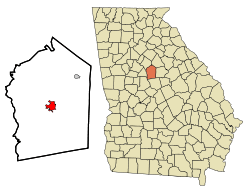 Location in Jasper County and the state of Georgia | |
| Coordinates: 33°18′12″N 83°41′9″W / 33.30333°N 83.68583°WCoordinates: 33°18′12″N 83°41′9″W / 33.30333°N 83.68583°W | |
| Country | United States |
| State | Georgia |
| County | Jasper |
| Area | |
| • Total | 3 sq mi (7.9 km2) |
| • Land | 3 sq mi (7.8 km2) |
| • Water | 0 sq mi (0.1 km2) |
| Elevation | 679 ft (207 m) |
| Population (2000) | |
| • Total | 2,428 |
| • Density | 809.3/sq mi (307.3/km2) |
| Time zone | Eastern (EST) (UTC-5) |
| • Summer (DST) | EDT (UTC-4) |
| ZIP code | 31064 |
| Area code(s) | 706 |
| FIPS code | 13-52416[1] |
| GNIS feature ID | 0328830[2] |
| Website | www.monticelloga.org |


Monticello is the largest city and the county seat of Jasper County, Georgia,[3] United States. The city includes historic buildings such as the Jasper County Courthouse, Monticello High School and the Monticello Historic District. The population was 2,428 at the 2000 census. It is 61 miles south of Atlanta.
History
Monticello was founded in 1808 as seat of the newly formed Jasper County. It was incorporated as a town in 1810 and as a city in 1901.[4]
On January 14, 1915, about 100 white men of Monticello formed a lynch mob and lynched a black family of four, including two married women. They took Dan Barber, his son Jesse Barber, and two married daughters Bula and Ella (Barber) Charles from the county jail, where they had been put after being arrested for attacking the chief of police. He had challenged Dan Barber in his house for making liquor illegally. The mob shot and hanged each of the four.[5]
Geography
Monticello is located at 33°18′12″N 83°41′9″W / 33.30333°N 83.68583°W (33.303247, -83.685766).[6]
According to the United States Census Bureau, the city has a total area of 3.0 square miles (7.8 km2), of which, 3.0 square miles (7.8 km2) of it is land and 0.04 square miles (0.10 km2) of it (0.66%) is water.
Demographics
| Historical population | |||
|---|---|---|---|
| Census | Pop. | %± | |
| 1880 | 511 | — | |
| 1890 | 849 | 66.1% | |
| 1900 | 1,106 | 30.3% | |
| 1910 | 1,508 | 36.3% | |
| 1920 | 1,823 | 20.9% | |
| 1930 | 1,593 | −12.6% | |
| 1940 | 1,746 | 9.6% | |
| 1950 | 1,918 | 9.9% | |
| 1960 | 1,931 | 0.7% | |
| 1970 | 2,132 | 10.4% | |
| 1980 | 2,382 | 11.7% | |
| 1990 | 2,289 | −3.9% | |
| 2000 | 2,428 | 6.1% | |
| 2010 | 2,657 | 9.4% | |
| Est. 2015 | 2,615 | [7] | −1.6% |
As of the census[1] of 2000, there were 2,428 people, 927 households, and 609 families residing in the city. The population density was 805.8 people per square mile (311.4/km²). There were 1,006 housing units at an average density of 333.9 per square mile (129.0/km²). The racial makeup of the city was 44.77% White, 53.50% African American, 0.12% Native American, 0.37% Asian, 0.70% from other races, and 0.54% from two or more races. Hispanic or Latino of any race were 3.17% of the population.
There were 927 households out of which 33.9% had children under the age of 18 living with them, 40.0% were married couples living together, 22.0% had a female householder with no husband present, and 34.3% were non-families. 31.1% of all households were made up of individuals and 14.7% had someone living alone who was 65 years of age or older. The average household size was 2.56 and the average family size was 3.21.
In the city the population was spread out with 28.3% under the age of 18, 8.2% from 18 to 24, 26.0% from 25 to 44, 21.6% from 45 to 64, and 15.9% who were 65 years of age or older. The median age was 36 years. For every 100 females there were 79.7 males. For every 100 females age 18 and over, there were 73.1 males.
The median income for a household in the city was $35,058, and the median income for a family was $46,705. Males had a median income of $30,565 versus $21,793 for females. The per capita income for the city was $15,743. About 16.9% of families and 21.4% of the population were below the poverty line, including 24.6% of those under age 18 and 20.2% of those age 65 or over.
Education
Jasper County School District
The Jasper County School District holds pre-school to grade twelve, and consists of two elementary schools (K-2 & 3-5 respectively), a middle school, and a high school.[9] The district has 132 full-time teachers and over 2,181 students.[10]
- Jasper County Primary School
- Washington Park Elementary School
- Jasper County Middle School
- Jasper County High School
Piedmont Academy - K3-12, co-ed, member of Georgia Independent School Association, established 1970
Notable natives and residents
- James Barney Cobb Jr. (professionally known as J.R. Cobb) - guitarist, songwriter and member of the Classics IV and the Atlanta Rhythm Section
- William A. Connelly - the sixth Sergeant Major of the Army
- Rob Evan - singer, actor in many Broadway musicals, including The Dream Engine
- Willis Flournoy - Negro League baseball player
- Buckshot Jones - NASCAR driver
- Ulysses Norris - University of Georgia football player; seven-year NFL career with the Detroit Lions (5 years) and Buffalo Bills (2 years)[11]
- John Gill Shorter - 17th governor of Alabama
- Sherry Smith - Major League Baseball player, pitched in two World Series
- Odell Thurman - University of Georgia and NFL football player
- Trisha Yearwood - country singer
Clayton Dana - Songwriter, owner operator of Drunken Sports YouTube and Facebook
- [James Campbell]Retired Atlanta Police Officer/Best Selling Author:"29 Murders"/"Southern Gold"/"Telling It Like It Is"
Representation in other media
- The Bingo Long Traveling All-Stars & Motor Kings (1976) had many scenes filmed in Monticello. The exteriors of buildings on the town square were remodeled to appear of the era of the movie.
- Many scenes of My Cousin Vinny (1992) were set at the courthouse and town square, and other scenes were also shot in town.
Climate
Climate is characterized by relatively high temperatures and evenly distributed precipitation throughout the year. The Köppen Climate Classification subtype for this climate is "Cfa" (Humid Subtropical Climate).[12]
| Climate data for Monticello, Georgia | |||||||||||||
|---|---|---|---|---|---|---|---|---|---|---|---|---|---|
| Month | Jan | Feb | Mar | Apr | May | Jun | Jul | Aug | Sep | Oct | Nov | Dec | Year |
| Average high °C (°F) | 13 (56) |
15 (59) |
19 (67) |
24 (76) |
28 (83) |
32 (89) |
33 (91) |
32 (90) |
30 (86) |
24 (76) |
19 (66) |
14 (57) |
1 (34) |
| Average low °C (°F) | 1 (34) |
2 (35) |
6 (42) |
10 (50) |
14 (58) |
19 (66) |
21 (69) |
20 (68) |
17 (63) |
11 (51) |
5 (41) |
2 (35) |
11 (51) |
| Average precipitation mm (inches) | 112 (4.4) |
114 (4.5) |
140 (5.5) |
97 (3.8) |
86 (3.4) |
100 (4) |
124 (4.9) |
109 (4.3) |
81 (3.2) |
71 (2.8) |
79 (3.1) |
107 (4.2) |
1,227 (48.3) |
| Average precipitation days | 9 | 8 | 9 | 7 | 8 | 9 | 10 | 9 | 7 | 5 | 6 | 8 | 97 |
| Source: Weatherbase [13] | |||||||||||||
Geology and Soils
The bedrock under Monticello is an intermediate-to-mafic type on which dark red clay with dark reddish brown loam topsoil is mapped as Lloyd series.[14][15]
References
- 1 2 "American FactFinder". United States Census Bureau. Retrieved 2008-01-31.
- ↑ "US Board on Geographic Names". United States Geological Survey. 2007-10-25. Retrieved 2008-01-31.
- ↑ "Find a County". National Association of Counties. Retrieved 2011-06-07.
- ↑ Hellmann, Paul T. (May 13, 2013). Historical Gazetteer of the United States. Routledge. p. 240. Retrieved 30 November 2013.
- ↑ "Whole Family Lynched". New York Times. January 16, 1915.
- ↑ "US Gazetteer files: 2010, 2000, and 1990". United States Census Bureau. 2011-02-12. Retrieved 2011-04-23.
- ↑ "Annual Estimates of the Resident Population for Incorporated Places: April 1, 2010 to July 1, 2015". Retrieved July 2, 2016.
- ↑ "Census of Population and Housing". Census.gov. Retrieved June 4, 2015.
- ↑ Georgia Board of Education, Retrieved June 20, 2010.
- ↑ School Stats, Retrieved June 20, 2010.
- ↑ http://www.databasefootball.com/players/playerpage.htm?ilkid=NORRIULY01
- ↑ Climate Summary for Monticello, Georgia
- ↑ "Weatherbase.com". Weatherbase. 2013. Retrieved on August 16, 2013.
- ↑ http://casoilresource.lawr.ucdavis.edu/gmap/
- ↑ https://soilseries.sc.egov.usda.gov/OSD_Docs/L/LLOYD.html
External links
- The City of Monticello official site
- Hebron Baptist Church historical marker
- Jackson Springs historical marker
- Site of Inn historical marker
|  | |||||||
|
| ||||||||
| ||||||||
Municipalities and communities of Jasper County, Georgia, United States | ||
|---|---|---|
| City |  | |
| Town | ||
| Unincorporated community | ||