Fayette County, Georgia
| Fayette County, Georgia | ||
|---|---|---|
|
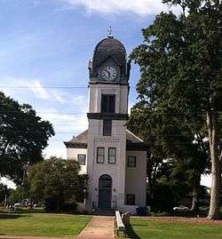
Fayette County Courthouse in Fayetteville | ||
| ||
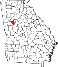 Location in the U.S. state of Georgia | ||
 Georgia's location in the U.S. | ||
| Founded | May 15, 1821 | |
| Named for | Marquis de Lafayette | |
| Seat | Fayetteville | |
| Largest city | Peachtree City | |
| Area | ||
| • Total | 199 sq mi (515 km2) | |
| • Land | 194 sq mi (502 km2) | |
| • Water | 5.0 sq mi (13 km2), 2.5% | |
| Population (est.) | ||
| • (2015) | 110,714 | |
| • Density | 548/sq mi (212/km²) | |
| Congressional districts | 3rd, 13th | |
| Time zone | Eastern: UTC-5/-4 | |
| Website |
www | |

Fayette County is a county located in the north central portion of the U.S. state of Georgia. As of the 2010 census, the population was 106,567.[1] Fayette County was established in 1821. The county seat, Fayetteville, was established in 1823. Much of Fayette County is bordered on the east side by the Flint River.
Fayette County came into being after the Creek Indian cession of land at Indian Springs, Georgia. Designated in 1821, it and the county seat, Fayetteville, are named for the Marquis de Lafayette, one of General George Washington's ablest lieutenants in the American Revolutionary War.
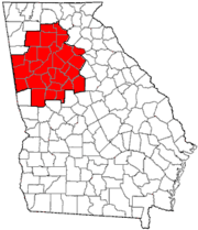
Fayette County is included in the Greater Atlanta Metropolitan Area. It is located south of Fulton County, home of the City of Atlanta. Fayette County is only minutes from the Hartsfield-Jackson International Airport. As a suburb of Atlanta, Fayette County has increased rapidly in population and development since the late 20th century.
Fayette County has five incorporated municipalities within its borders; Fayetteville, Brooks, Woolsey, Tyrone and Peachtree City. Formerly, Inman was also a municipality, but gave up its charter years ago.
History
Fayette County was created on May 15, 1821, from territory ceded by the Creek people, who had historically inhabited the area. It was named for the Marquis de Lafayette, French hero of the American Revolutionary War.[2] Located in the Piedmont, the county was originally developed for agriculture, primarily cotton cultivation.
Peachtree City was chartered in 1959 and developed there as the only planned community in the county and the Southeast; it covers 16,000-acres,[3] The county population increased rapidly during the late twentieth century and significant growth and development continues.
Government
Fayette County's local government is led by a board of five county commissioners, known as the governing authority of Fayette County. Until 2013, the county was divided into three "county commission districts". Three of the members of the board of commissioners were required to live inside one of the designated districts. The remaining two commissioners could live anywhere in the county. All members of the county commission were elected "at-large", which meant that at every election for county commissioners, all registered voters in the county were able to vote for the candidate(s) of their choice for each seat on the board. After a lawsuit was filed by the local branch of the NAACP, the county was forced to change its voting method from one of "at-large" voting to a "district" voting method. The county was required to establish five county commission districts. Each district has a commissioner living within its boundaries and only voters living within a district can vote for county commission candidates running from that specific district.
Geography
According to the U.S. Census Bureau, the county has a total area of 199 square miles (520 km2), of which 194 square miles (500 km2) is land and 5.0 square miles (13 km2) (2.5%) is water.[4]
The Flint River passes through the county. The entirety of Fayette County is located in the Upper Flint River sub-basin of the ACF River Basin (Apalachicola-Chattahoochee-Flint River Basin).[5]
Major highways
-
 State Route 54
 -
 State Route 74
 -
 State Route 85
 -
 State Route 92
 -
 State Route 138
 -
 State Route 279
 -
 State Route 314
Adjacent counties
- Fulton County – north
- Clayton County – east
- Spalding County – south
- Coweta County – west
Demographics
| Historical population | |||
|---|---|---|---|
| Census | Pop. | %± | |
| 1830 | 5,504 | — | |
| 1840 | 6,191 | 12.5% | |
| 1850 | 8,709 | 40.7% | |
| 1860 | 7,047 | −19.1% | |
| 1870 | 8,221 | 16.7% | |
| 1880 | 8,605 | 4.7% | |
| 1890 | 8,728 | 1.4% | |
| 1900 | 10,114 | 15.9% | |
| 1910 | 10,966 | 8.4% | |
| 1920 | 11,396 | 3.9% | |
| 1930 | 8,665 | −24.0% | |
| 1940 | 8,170 | −5.7% | |
| 1950 | 7,978 | −2.4% | |
| 1960 | 8,199 | 2.8% | |
| 1970 | 11,364 | 38.6% | |
| 1980 | 29,043 | 155.6% | |
| 1990 | 62,415 | 114.9% | |
| 2000 | 91,263 | 46.2% | |
| 2010 | 106,567 | 16.8% | |
| Est. 2015 | 110,714 | [6] | 3.9% |
| U.S. Decennial Census[7] 1790-1960[8] 1900-1990[9] 1990-2000[10] 2010-2013[1] | |||
Based on the 2010 census and 2013 estimates, Fayette County has 108,365 people. The racial makeup of the county was 71.7% White; 21.4% Black or African American; 0.4% Native American, 4.3% Asian, 0.1% Native Hawaiian and Other Pacific Islander; and 2.0% Two or More Races. 6.9% of the population was estimated as Hispanic or Latino of any race.[1]
2000 census
As of the census[11] of 2000, there were 91,263 people, 31,524 households, and 25,975 families residing in the county. The population density was 463 people per square mile (179/km²). There were 32,726 housing units at an average density of 166 per square mile (64/km²). The racial makeup of the county was 80.96% White, 12.87% Black or African American, 0.21% Native American, 2.42% Asian, 0.02% Pacific Islander, 0.76% from other races, and 1.25% from two or more races. 2.83% of the population were Hispanic or Latino of any race.
There were 31,524 households out of which 43.10% had children under the age of 18 living with them, 71.50% were married couples living together, 8.30% had a female householder with no husband present, and 17.60% were non-families. 15.00% of all households were made up of individuals and 5.50% had someone living alone who was 65 years of age or older. The average household size was 2.88 and the average family size was 3.20.
In the county the population was spread out with 29.10% under the age of 18, 6.50% from 18 to 24, 27.70% from 25 to 44, 27.80% from 45 to 64, and 8.90% who were 65 years of age or older. The median age was 38 years. For every 100 females there were 95.80 males. For every 100 females age 18 and over, there were 92.00 males.
The median income for a household in the county was $71,227, and the median income for a family was $78,853 (these figures had risen to $79,498 and $89,873 respectively as of a 2007 estimate[12]). Males had a median income of $54,738 versus $33,333 for females. The per capita income for the county was $29,464. About 2.00% of families and 2.60% of the population were below the poverty line, including 2.80% of those under age 18 and 4.60% of those age 65 or over.
2010 census
As of the 2010 United States Census, there were 106,567 people, 38,167 households, and 30,288 families residing in the county.[13] The population density was 548.3 inhabitants per square mile (211.7/km2). There were 40,793 housing units at an average density of 209.9 per square mile (81.0/km2).[14] The racial makeup of the county was 71.1% white, 20.1% black or African American, 3.9% Asian, 0.3% American Indian, 0.1% Pacific islander, 2.3% from other races, and 2.2% from two or more races. Those of Hispanic or Latino origin made up 6.3% of the population.[13] In terms of ancestry, 15.0% were English, 14.0% were German, 13.0% were Irish, and 8.1% were American.[15]
Of the 38,167 households, 39.5% had children under the age of 18 living with them, 65.7% were married couples living together, 10.3% had a female householder with no husband present, 20.6% were non-families, and 18.1% of all households were made up of individuals. The average household size was 2.78 and the average family size was 3.15. The median age was 42.4 years.[13]
The median income for a household in the county was $82,216 and the median income for a family was $92,976. Males had a median income of $68,381 versus $46,140 for females. The per capita income for the county was $35,076. About 3.4% of families and 4.7% of the population were below the poverty line, including 6.1% of those under age 18 and 3.8% of those age 65 or over.[16]
Education
Fayette County is served by the Fayette County School System. The governing authority for the school system is known as the Fayette County Board of Education, a board of five elected persons. As of a change in 2013 due to the federal lawsuit noted above, the five board members are elected from single-member districts. They hire a superintendent to manage daily operations of the schools.
High schools
- Fayette County High School
- McIntosh High School
- Sandy Creek High School
- Starr's Mill High School
- Whitewater High School
Alternative schools
- The Fayette County Alternative Education Program
Communities
Notable residents
- Andre 3000, rapper in the group Outkast
- Rick Ross, rapper
- Paris Bennett, singer
- Chris Benoit, pro wrestler
- Nancy Benoit, pro wrestler
- Furman Bisher, longtime late sports columnist, Atlanta Journal-Constitution
- Big Boi, rapper in the group Outkast
- Robert H. Brooks, former Chairman and CEO, Hooter's of America Inc.
- Zac Brown, Grammy award winning singer, Zac Brown Band
- Robert J Burch, Children's author
- Kandi Burruss, singer, reality TV star
- Kathy Cox, State School Superintendent
- Don 'D.C.' Curry
- Creflo Dollar, televangelist
- Mike Duke, Former CEO of Wal-Mart Stores Inc.
- Cee-Lo Green, rapper
- Lee Haney, retired professional bodybuilder and Mr. Olympia titleholder
- Evander Holyfield, retired professional boxer
- Tim Hudson, former starting pitcher with the Atlanta Braves and San Francisco Giants
- Calvin Johnson, former NFL receiver for the Detroit Lions, Sandy Creek HS and Georgia Tech Alum
- Emmanuel Lewis, actor, Webster
- Carole Marsh, children's author and founder of Gallopade International
- Paul Orndorff, pro wrestler
- Keshia Knight Pulliam, actress, The Cosby Show, Tyler Perry's House of Payne
- William Regal, pro wrestler
- Nellie Mae Rowe, artist
- Kelley O'Hara, United States Women's Soccer Player, 2011 FIFA World Cup silver medalist, 2012 Olympic gold medalist, 2015 FIFA World Cup gold medalist
- Ferrol Sams, physician, humorist, storyteller, and best-selling novelist.
- The Iron Sheik, retired wrestler
- Reed Sorenson, NASCAR driver
- Speech (rapper) and Arrested Development, hip-hop group
- Christian Taylor, Gold Medal Winner, 2012 Olympic Games (London) Men's Triple Jump
- Gy Waldron, creator and executive producer, The Dukes of Hazard
- John Waller, contemporary Christian singer
- Gary Anthony Williams, television and film actor
See also
References
- 1 2 3 "State & County QuickFacts". United States Census Bureau. Retrieved June 22, 2014.
- ↑ Gannett, Henry (1905). The Origin of Certain Place Names in the United States. Govt. Print. Off. p. 124.
- ↑ Carolyn Cary, "Fayette County", New Georgia Encyclopedia, 2006/2015
- ↑ "US Gazetteer files: 2010, 2000, and 1990". United States Census Bureau. 2011-02-12. Retrieved 2011-04-23.
- ↑ "Georgia Soil and Water Conservation Commission Interactive Mapping Experience". Georgia Soil and Water Conservation Commission. Retrieved 2015-11-19.
- ↑ "County Totals Dataset: Population, Population Change and Estimated Components of Population Change: April 1, 2010 to July 1, 2015". Retrieved July 2, 2016.
- ↑ "U.S. Decennial Census". United States Census Bureau. Archived from the original on May 11, 2015. Retrieved June 22, 2014.
- ↑ "Historical Census Browser". University of Virginia Library. Retrieved June 22, 2014.
- ↑ "Population of Counties by Decennial Census: 1900 to 1990". United States Census Bureau. Retrieved June 22, 2014.
- ↑ "Census 2000 PHC-T-4. Ranking Tables for Counties: 1990 and 2000" (PDF). United States Census Bureau. Retrieved June 22, 2014.
- ↑ "American FactFinder". United States Census Bureau. Retrieved 2011-05-14.
- ↑ "Fayette County, Georgia – Fact Sheet – American FactFinder". Factfinder.census.gov. Retrieved 2010-07-22.
- 1 2 3 "DP-1 Profile of General Population and Housing Characteristics: 2010 Demographic Profile Data". United States Census Bureau. Retrieved 2015-12-29.
- ↑ "Population, Housing Units, Area, and Density: 2010 - County". United States Census Bureau. Retrieved 2015-12-29.
- ↑ "DP02 SELECTED SOCIAL CHARACTERISTICS IN THE UNITED STATES – 2006-2010 American Community Survey 5-Year Estimates". United States Census Bureau. Retrieved 2015-12-29.
- ↑ "DP03 SELECTED ECONOMIC CHARACTERISTICS – 2006-2010 American Community Survey 5-Year Estimates". United States Census Bureau. Retrieved 2015-12-29.
Other reading
- Carolyn C. Cary, ed., The History of Fayette County, 1821-1971 (Fayetteville, Ga.: Fayette County Historical Society, 1977).
- Fayette County Historical Society, The Fayette County Georgia Heritage Book (Waynesville, N.C.: Walsworth, 2003).
External links
- Fayette County Board of Commissioners
- Fayette County Board of Education
- Fayette County Development Authority (Updated demographic information)
- Young Professionals of Fayette County
- Fayette County historical marker
 |
Fulton County | | ||
| Coweta County | |
Clayton County | ||
| ||||
| | ||||
| Spalding County |
Municipalities and communities of Fayette County, Georgia, United States | ||
|---|---|---|
| Cities | | |
| Towns | ||
| Unincorporated community | ||
|  | |||||||
|
| ||||||||
| ||||||||
Template:Georgia
Coordinates: 33°25′N 84°29′W / 33.41°N 84.49°W