Candler-McAfee, Georgia
| Candler-McAfee, Georgia | |
|---|---|
| Census-designated place (CDP) | |
 Location in DeKalb County and the state of Georgia | |
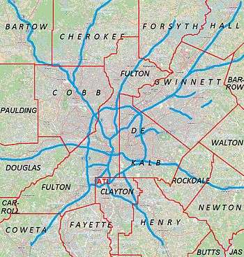 Candler‑McAfee CDP Location in Metro Atlanta | |
| Coordinates: 33°43′38″N 84°16′29″W / 33.72722°N 84.27472°WCoordinates: 33°43′38″N 84°16′29″W / 33.72722°N 84.27472°W | |
| Country | United States |
| State | Georgia |
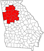
| County | DeKalb |
| Area | |
| • Total | 7 sq mi (18.1 km2) |
| • Land | 7 sq mi (18.1 km2) |
| • Water | 0 sq mi (0 km2) |
| Population (2010) | |
| • Total | 23,025 |
| • Density | 3,300/sq mi (1,300/km2) |
| Time zone | Eastern (EST) (UTC-5) |
| • Summer (DST) | EDT (UTC-4) |
| FIPS code | 13-12834[1] |

Candler-McAfee is a census-designated place (CDP) in DeKalb County, Georgia, United States. It is part of the Atlanta metropolitan area. The population was 23,025 at the 2010 census.[2]
Geography
Candler-McAfee is located in East Atlanta outside of East Lake .[3] The Belvedere Park CDP is to the north and Panthersville CDP is to the south.
According to the United States Census Bureau, the CDP has a total area of 7.0 square miles (18 km2), of which 0.04 square miles (0.10 km2), or 0.29%, is water.
Landmarks
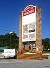
The area is home to DeKalb Fire Station 26 and its iconic water tower.
Demographics
| Historical population | |||
|---|---|---|---|
| Census | Pop. | %± | |
| 1980 | 27,306 | — | |
| 1990 | 29,491 | 8.0% | |
| 2000 | 28,294 | −4.1% | |
| 2010 | 23,025 | −18.6% | |
| source:[2][4] | |||
As of the census[1] of 2000, there were 28,294 people, 9,030 households, and 6,926 families residing in the CDP. The population density was 4,054.2 people per square mile (1,565.1/km²). There were 9,415 housing units at an average density of 1,349.0/sq mi (520.8/km²). The racial makeup of the CDP was 3.31% White, 95.17% African American, 0.20% Native American, 0.15% Asian, 0.01% Pacific Islander, 0.41% from other races, and 0.76% from two or more races. Hispanic or Latino of any race were 0.93% of the population.
There were 9,030 households out of which 32.7% had children under the age of 18 living with them, 36.9% were married couples living together, 33.1% had a female householder with no husband present, and 23.3% were non-families. 18.2% of all households were made up of individuals and 3.4% had someone living alone who was 65 years of age or older. The average household size was 3.08 and the average family size was 3.46.
In the CDP the population was spread out with 28.0% under the age of 18, 10.7% from 18 to 24, 28.2% from 25 to 44, 25.7% from 45 to 64, and 7.5% who were 65 years of age or older. The median age was 33 years. For every 100 females there were 87.0 males. For every 100 females age 18 and over, there were 81.7 males.
The median income for a household in the CDP was $38,152, and the median income for a family was $40,368. Males had a median income of $30,218 versus $25,887 for females. The per capita income for the CDP was $15,092. About 10.9% of families and 13.6% of the population were below the poverty line, including 17.1% of those under age 18 and 14.9% of those age 65 or over. By 2007 the poverty rate had exploded to 27.5%, one of the highest rates in the country.
Neighborhoods
Neighborhoods in the CDP with websites for their neighborhood association are:
- East Lake Terrace, between Glenwood (N), McAfee (S), Parker (W) and Candler (E)
References
- 1 2 "American FactFinder". United States Census Bureau. Archived from the original on 2013-09-11. Retrieved 2008-01-31.
- 1 2 "Race, Hispanic or Latino, Age, and Housing Occupancy: 2010 Census Redistricting Data (Public Law 94-171) Summary File (QT-PL), Candler-McAfee CDP, Georgia". U.S. Census Bureau, American FactFinder 2. Archived from the original on September 11, 2013. Retrieved October 28, 2011.
- ↑ "US Gazetteer files: 2010, 2000, and 1990". United States Census Bureau. 2011-02-12. Retrieved 2011-04-23.
- ↑ "CENSUS OF POPULATION AND HOUSING (1790-2000)". U.S. Census Bureau. Retrieved 2010-07-17.
|  | |||||||
|
| ||||||||
| ||||||||
Municipalities and communities of DeKalb County, Georgia, United States | ||
|---|---|---|
| Cities | 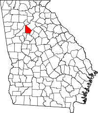 | |
| CDPs | ||
| Neighborhoods and unincorporated communities | ||
| Ghost town | ||
| Footnotes | ‡This populated place also has portions in an adjacent county or counties | |