Stockbridge, Georgia
| Stockbridge, Georgia, Metro Atlanta | |
|---|---|
| City | |
|
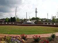
Stockbridge City Hall | |
 Location in Henry County and the state of Georgia | |
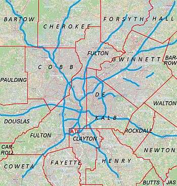 Stockbridge Location of Stockbridge in Metro Atlanta | |
| Coordinates: 33°32′3″N 84°13′52″W / 33.53417°N 84.23111°WCoordinates: 33°32′3″N 84°13′52″W / 33.53417°N 84.23111°W | |
| Country | United States |
| State | Georgia |
| County | Henry |
| Area | |
| • Total | 13.4 sq mi (34.8 km2) |
| • Land | 13.3 sq mi (34.5 km2) |
| • Water | 0.1 sq mi (0.3 km2) |
| Elevation | 801 ft (244 m) |
| Population (2010) | |
| • Total | 25,637 |
| • Density | 1,927.5/sq mi (744.0/km2) |
| Time zone | Eastern (EST) (UTC-5) |
| • Summer (DST) | EDT (UTC-4) |
| ZIP code | 30281 |
| Area code(s) | 770/678/470 |
| FIPS code | 13-73704[1] |
| GNIS feature ID | 0342357[2] |
| Website | City of Stockbridge |

Stockbridge is a city in Henry County, Georgia, United States with a population of 25,637 as of the 2010 census.
Stockbridge is part of the Atlanta metropolitan area.
History
The area was settled in 1829 when Concord Methodist Church was organized near present today Old Stagecoach Road. It was granted a post office on April 5, 1847 named for a traveling Professor, Levi Stockbridge, who passed through the area many times before the Post Office was built. He was said to be well known and respected in his namesake community. Others contend that the city was named after Thomas Stock, who was State Surveyor and President of the Georgia State Senate in the 1820s.
In 1881, the East Tennessee, Virginia and Georgia Railroad was to pass through Stockbridge between Macon and Atlanta. The settlers who owned the land about Old Stockbridge asked so much for their land that two prominent Atlanta citizens, John W. Grant and George W. Adair, bought a tract about a mile south of Old Stockbridge and offered lots at a reasonable price. Here the railroad built their depot and many lots were sold. The depot was located about 600 feet (180 m) north of what is now North Henry Blvd but was destroyed by the Southern Railway in the early 1980s.
Stockbridge was incorporated as a town in 1895 and as a city August 6, 1920.
The Aaron and Margaret Parker Jr. House and Walden-Turner House in Stockbridge are listed on the National Register of Historic Places.
Naming mystery
On May 6, 1992, Mayor Rudy Kelley received a letter from Mr. John Stockbridge of South Carolina requesting a letter of "Greeting" from the City of Stockbridge to the attendees of the first reunion of the Stockbridge family. In his letter, he mentioned that he grew up in Georgia and had been told as a child that the City of Stockbridge was named after his great-great-grandfather Levi Stockbridge who traveled back and forth from the north to his property in Florida and stopped here on his journey.
Levi Stockbridge was born on March 13, 1820, and fits the time frame just prior to the Civil War. Levi would have been 27 years of age when Stockbridge was assigned a post office in 1847.
Until May 6, 1992, there had never been a name other than Professor Stockbridge. At that time, Levi Stockbridge was mentioned as the person for whom the city may have been named.
It is not certain that Levi Stockbridge was the individual for whom the citizens of the community named their post office and village. However, through John Stockbridge’s letters and many conversations with him, it is believed that this is the rightful Professor Stockbridge who had been unknown for 146 years.
Recent history
Eminent domain controversy
In late 2005 the City of Stockbridge engaged in a highly controversial preemptive use of eminent domain to buy over 16 acres (65,000 m2) of land near the current city hall running along East Atlanta Road. The City reportedly wanted to build a new city hall, park/square, and a small tract of land for new and more desirable business to incorporate a new image for the city. Stockbridge became the focus of national news and was also one of the largest issues in the 2006 Georgia General Assembly and their efforts to prevent abuse of eminent domain.
Many of the citizens of Stockbridge and Henry County were surprised by the apparent abuse of eminent domain by the city. Early in 2006, a protest was organized by the NAACP and supported by the Republican and Libertarian parties from the county. Syndicated Atlanta talk show host Neal Boortz said during his show, "Private property rights are dead in Stockbridge, Georgia" and called members of the Stockbridge City Council "sorry bastards."

The Henry County Board of Commissioners took a stance on the issue by unanimously approving a non-binding resolution that the county would not take land for economic development purposes. Although the county legally has no say of what the City of Stockbridge can do with its land and its use of eminent domain. Many have said it was just a political strategy being that Henry County has shown recently in voting history to be one of the most conservative counties in the Atlanta metro area.
The conflict between the city and the property owners came to an end on February 2, 2007 as the Georgia Court of Appeals threw out the condemnation. Only one store, a local florist, beat the eminent domain and was allowed to keep its store and property. An infamous brick fence was erected around the florist shop to separate it from the new City Hall. It is well known in the area for its awkward shape.
However, in October 2009 the battle between the owner of the florist shop and the city started up again. When the florist shop put up signs for a mayoral and city council candidates who opposed the eminent domain abuse, workers at city hall started putting up bales of hay to block the sign. When a local Television reporter asked who ordered the bales of hay to be put up, city workers refused to comment.
New City Hall
After February 2007 the city had new plans drawn up to build the new city hall. The plans call for the new city hall and park and green space to all be built around the Stockbridge Florist shop that started the now famous Eminent Domain lawsuit.
The city says that the new development will strengthen the old and worn down downtown business district. The Stockbridge City Manager Ted Strickland, said that the new city hall was absolutely necessary, because some current city employees are working out of closets and supply rooms.
During interviews with city workers, they complained that it was interesting how the city could "spend 2 million dollars on a water fountain" but could not give its employees a mere $0.50 raise. After being more than 1 million dollars over budget and 2 years behind on the project the new city hall was opened in August 2009.
Geography
Stockbridge is located at 33°32′3″N 84°13′52″W / 33.53417°N 84.23111°W (33.534068, -84.231185).[3]
According to the United States Census Bureau, the city has a total area of 13.4 square miles (35 km2), of which, 13.3 square miles (34 km2) of it is land and 0.1 square miles (0.26 km2) of it (0.45%) is water.
Demographics
| Historical population | |||
|---|---|---|---|
| Census | Pop. | %± | |
| 1890 | 287 | — | |
| 1920 | 386 | — | |
| 1930 | 392 | 1.6% | |
| 1940 | 443 | 13.0% | |
| 1950 | 717 | 61.9% | |
| 1960 | 1,201 | 67.5% | |
| 1970 | 1,561 | 30.0% | |
| 1980 | 2,103 | 34.7% | |
| 1990 | 3,359 | 59.7% | |
| 2000 | 9,853 | 193.3% | |
| 2010 | 25,636 | 160.2% | |
| Est. 2015 | 28,202 | [4] | 10.0% |
2000 census
As of the census[1] of 2000, there were 9,853 people, 3,749 households, and 2,654 families residing in the city. The population density was 900.0 people per square mile (347.4/km²). There were 3,991 housing units at an average density of 364.6 per square mile (140.7/km²). The racial makeup of the city was 71.63% White, 20.51% African American, 0.27% Native American, 4.55% Asian, 0.13% Pacific Islander, 1.44% from other races, and 1.46% from two or more races. Hispanic or Latino of any race were 4.21% of the population.
There were 3,749 households out of which 39.7% had children under the age of 18 living with them, 51.7% were married couples living together, 14.4% had a female householder with no husband present, and 29.2% were non-families. 22.3% of all households were made up of individuals and 4.5% had someone living alone who was 65 years of age or older. The average household size was 2.61 and the average family size was 3.06.
In the city the population was spread out with 28.3% under the age of 18, 8.8% from 18 to 24, 38.1% from 25 to 44, 18.1% from 45 to 64, and 6.7% who were 65 years of age or older. The median age was 31 years. For every 100 females there were 91.4 males. For every 100 females age 18 and over, there were 85.2 males.
The median income for a household in the city was $48,296, and the median income for a family was $51,341. Males had a median income of $38,457 versus $28,938 for females. The per capita income for the city was $21,380. 6.8% of the population and 6.0% of families were below the poverty line. 5.9% of those under the age of 18 and 17.1% of those 65 and older are living below the poverty line.
2010 census
As of the 2010 United States Census, there were 25,636 people, 9,499 households, and 6,536 families residing in the city.[6] The population density was 1,927.5 inhabitants per square mile (744.2/km2). There were 10,312 housing units at an average density of 775.4 per square mile (299.4/km2).[7] The racial makeup of the city was 28.8% white, 55.7% black or African American, 7.6% Asian, 0.3% American Indian, 0.1% Pacific islander, 3.8% from other races, and 3.7% from two or more races. Those of Hispanic or Latino origin made up 9.5% of the population.[6]
Of the 9,499 households, 41.2% had children under the age of 18 living with them, 41.6% were married couples living together, 22.0% had a female householder with no husband present, 31.2% were non-families, and 26.6% of all households were made up of individuals. The average household size was 2.70 and the average family size was 3.29. The median age was 33.8 years.[6]
Parks and recreation
- Clark Community Park.
- Gardner Park.
- Memorial Park.
- Monument Park at Eagle's Landing.
- Reeves Creek Trail.
- Eagles Landing Country Club.
- Bridgefest - held annually on the last weekend in September.
- Holiday Gala - held annually.
- Sounds of Summer concert series - held annually on City Hall lawn.
- Screen on the Green held annually - hosted by Stockbridge Main Street.
Education
Public schools
Stockbridge is served by the Henry County School District. Schools include:
- Stockbridge Elementary School.
- Smith Barnes Elementary School.
- Cotton Indian Elementary School.
- Pate's Creek Elementary School.
- Pleasant Grove Elementary School.
- Stockbridge Middle School.
- Woodland Middle School.
- Stockbridge High School.
- Woodland High School.
- Dutchtown High School.
- Dutchtown Middle and Elementary
- Red Oak Elementary School.
- Union Grove Middle and High School
- Luella Middle and High School
- Henry County High School
- Ola Middle and High School
Private schools
- Community Christian School
- Mount Vernon Christian Academy
- Sunbrook Academy at Stockbridge [8]
Infrastructure
Transportation
- Xpress GA provides local bus service.
- The Berry Hill Airport is located nearby and provides regional air service.
Stockbridge is served by the following highways:
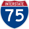 Interstate 75
 Interstate 675
 U.S. Highway 23
 Georgia State Route 42
 Georgia State Route 138
 Georgia State Route 401
 Georgia State Route 413
Notable people
- Mark O. Barton, spree killer.
- Joey Clanton, race car driver.
- Kyle Davies, professional baseball player.
- Max Gresham, stock car racing driver.
- Martin Luther King, Sr., Baptist pastor, missionary, and early leader in the American Civil Rights Movement; father of Martin Luther King, Jr.
- Phil McCullough, professional baseball player.
- Lee H. Phillips, awarded the Medal of Honor for his actions during the Korean War.
- Dean Roland, Ed Roland, and Will Turpin of the alternative rock band Collective Soul.
- Ricky Sanders, race car driver.
- Bruce Irvin, NFL player Seattle Seahawks
- Mark Hall, Lead Singer of contemporary Christian band Casting Crowns
References
- 1 2 "American FactFinder". United States Census Bureau. Retrieved 2008-01-31.
- ↑ "US Board on Geographic Names". United States Geological Survey. 2007-10-25. Retrieved 2008-01-31.
- ↑ "US Gazetteer files: 2010, 2000, and 1990". United States Census Bureau. 2011-02-12. Retrieved 2011-04-23.
- ↑ "Annual Estimates of the Resident Population for Incorporated Places: April 1, 2010 to July 1, 2015". Retrieved July 2, 2016.
- ↑ "Census of Population and Housing". Census.gov. Archived from the original on May 11, 2015. Retrieved June 4, 2015.
- 1 2 3 "DP-1 Profile of General Population and Housing Characteristics: 2010 Demographic Profile Data". United States Census Bureau. Retrieved 2016-11-28.
- ↑ "Population, Housing Units, Area, and Density: 2010 - County". United States Census Bureau. Retrieved 2016-11-28.
- ↑ Sunbrook Academy at Stockbridge
External links
 |
Rex | Ellenwood | Conyers | |
| Jonesboro | |
McDonough | ||
| ||||
| | ||||
| Jonesboro | Hampton | McDonough |
|  | |||||||
|
| ||||||||
| ||||||||
Municipalities and communities of Henry County, Georgia, United States | ||
|---|---|---|
| Cities | 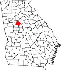 | |
| CDP | ||
| Unincorporated communities | ||
| Footnotes | ‡This populated place also has portions in an adjacent county or counties | |