Lilburn, Georgia
| Lilburn, Georgia | |
|---|---|
| City | |
| Motto: "Small town, Big difference" | |
 Location in Gwinnett County and the state of Georgia | |
| Coordinates: 33°53′20″N 84°8′27″W / 33.88889°N 84.14083°WCoordinates: 33°53′20″N 84°8′27″W / 33.88889°N 84.14083°W | |
| Country | United States |
| State | Georgia |
| County | Gwinnett |
| Government | |
| • Mayor | Johnny Crist |
| Area | |
| • Total | 6.4 sq mi (16.5 km2) |
| • Land | 6.3 sq mi (16.4 km2) |
| • Water | 0.04 sq mi (0.1 km2) |
| Elevation | 951 ft (290 m) |
| Population (2010) | |
| • Total | 11,596 |
| • Density | 1,836/sq mi (708.8/km2) |
| Time zone | Eastern (EST) (UTC-5) |
| • Summer (DST) | EDT (UTC-4) |
| ZIP codes | 30047-30048 |
| Area code(s) | 470/678/770 |
| FIPS code | 13-46356 |
| GNIS feature ID | 0332213[1] |
| Website |
www |
Lilburn is a city in Gwinnett County, Georgia, United States. The population was 11,596 at the 2010 census.[2] The estimated population was 12,655 in 2015.[3] It is a developed suburb of Atlanta and a part of the Atlanta metropolitan area.
Geography
Lilburn is located in western Gwinnett County at 33°53′20″N 84°8′27″W / 33.88889°N 84.14083°W (33.888853, -84.140897).[4] U.S. Route 29 (Lawrenceville Highway) passes through the center of town, leading southwest 19 miles (31 km) to downtown Atlanta and northeast 11 miles (18 km) to Lawrenceville, the Gwinnett County seat.
According to the United States Census Bureau, Lilburn has a total area of 6.4 square miles (16.5 km2), of which 6.3 square miles (16.4 km2) is land and 0.04 square miles (0.1 km2), or 0.82%, is water.[2]
Historical background
The city of Lilburn was founded in 1890 by the Seaboard Air Line Railway. The area previously known as "McDaniel" was renamed "Lilburn", after the general superintendent of the railroad, Lilburn Trigg Myers of Virginia. (The basis of the name change got no official mention at the time, and historical researchers did not confirm the specific link to Myers until the 1990s.) The town prospered and was incorporated as Lilburn on July 27, 1910.
A devastating fire and hard economic times in the 1920s ended the prosperity, and the city of Lilburn ceased to exist. A revitalization of the original historic area has emerged with shopping and restaurants in the Old Town district which has been described as a "Slice of History."
Demographics
| Historical population | |||
|---|---|---|---|
| Census | Pop. | %± | |
| 1930 | 179 | — | |
| 1960 | 753 | — | |
| 1970 | 1,668 | 121.5% | |
| 1980 | 3,765 | 125.7% | |
| 1990 | 9,301 | 147.0% | |
| 2000 | 11,307 | 21.6% | |
| 2010 | 11,596 | 2.6% | |
| Est. 2015 | 12,655 | [3] | 9.1% |
As of 2010 Lilburn had a population of 11,596. The median age was 36.3. The racial and ethnic composition of the population was 52.7% white (34.3% non-Hispanic white), 24.4% black or African American, 0.5% Native American, 0.8% Asian Indian, 0.4% other Asian, 5.3% from some other race (0.3% non-Hispanic from some other race) and 2.8% from two or more races. 27.4% of the population was Hispanic or Latino.[6]
As of the census of 2000, there were 11,307 people, 3,943 households, and 2,835 families residing in the city. The population density was 1,837.6 people per square mile (709.9/km²). There were 4,049 housing units at an average density of 658.0 per square mile (254.2/km²). The racial makeup of the city was 69.09% White, 11.93% African American, 0.34% Native American, 11.69% Asian, 0.03% Pacific Islander, 4.81% from other races, and 2.11% from two or more races. Hispanic or Latino of any race were 13.22% of the population.
There were 3,943 households out of which 38.1% had children under the age of 18 living with them, 57.1% were married couples living together, 7.1% had a female householder with no husband present, and 28.1% were non-families. 0.4% of all households were made up of individuals and 6.3% had someone living alone who was 65 years of age or older. The average household size was 2.80 and the average family size was 3.28.
In the city the population was spread out with 25.7% under the age of 18, 9.1% from 18 to 24, 33.7% from 25 to 44, 23.3% from 45 to 64, and 8.3% who were 65 years of age or older. The median age was 35 years. For every 100 females there were 97.1 males. For every 100 females age 18 and over, there were 92.5 males.
The median income for a household in the city was $53,707, and the median income for a family was $62,563. Males had a median income of $38,289 versus $28,996 for females. The per capita income for the city was $22,503. About 4.7% of families and 6.1% of the population were below the poverty line, including 7.1% of those under age 18 and 10.7% of those age 65 or over.
Education
Primary and secondary schools
Public schools
Gwinnett County Public Schools operates public schools.
The following have Lilburn addresses:
Elementary schools
- Arcado Elementary (Parkview)
- Camp Creek Elementary (Parkview)
- R.D. Head Elementary (Brookwood)
- G.H. Hopkins Elementary (Meadowcreek)
- Knight Elementary (Parkview)
- Lilburn Elementary (Meadowcreek)
- Rebecca Minor Elementary (Berkmar)
- Mountain Park Elementary (Parkview)
Middle schools
- Berkmar Middle School (Berkmar)
- Lilburn Middle School (Meadowcreek)
- Trickum Middle School (Parkview)
- Five Forks Middle School (Brookwood)
High schools
- Berkmar High School (Berkmar)
- Parkview High School (Parkview)
- Meadowcreek High School (Meadowcreek) - Norcross
- Brookwood High School (Brookwood) - Snellville
Private schools
- Killian Hill Christian School
- Parkview Christian School
- Providence Christian Academy
- St. John Neumann Regional Catholic School
- Gwinnett College
- Regina Caeli Academy
Public libraries
Gwinnett County Public Library operates the Mountain Park Branch and the Hillcrest Branch in Lilburn.[7]
Cityscape and landmarks
Lilburn's downtown is currently undergoing a revitalization project, as the city is constructing a new City Hall and public library, having already rerouted Main Street's intersection with US 29.[8]
The BAPS Shri Swaminarayan Mandir Atlanta is located in Lilburn, approximately two miles southwest of the city center. It is the tallest building in the city and the largest Swaminarayan temple outside of India.[9]
Events
Lilburn Daze Arts and Crafts Festival, hosted and organized by the Lilburn Woman's Club, an affiliate of the GFWC, is celebrated on the second Saturday in October and features over 200 vendors. This one-day event features local artisans, children's activities, live entertainment, food, hayrides, a health screening tent and a petting zoo. The annual Christmas Parade, held on the first Saturday in December, usually features about 100 entrants marching down Main Street on a route ending at Lilburn City Park. Proceeds from this event fund local scholarships and many other community improvement projects in the greater Lilburn area.
Notable people
- Aprotim Cory Bhowmik, award-winning scientist and namesake of a minor planet[10]
- Blake Brettschneider, current Major League Soccer forward for D.C. United
- Kevin Cone, NFL player, Atlanta Falcons
- Jeff Francoeur, Major League Baseball player
- Kimberly Gittings, Miss Georgia 2009 and in Miss USA Pageant 2009
- Brendan Hanrahan and Chad Leathers, co-creators of Cupid's Undie Run, a nationwide fundraising event for the Children's Tumor Foundation
- Sean Johnson, current Major League Soccer goalkeeper for Chicago Fire
- Kate Michael, Miss District of Columbia, 2006
- Michael Palmer, NFL player Atlanta Falcons
- Eric Shanteau, Olympic swimmer
- Jon Stinchcomb, football player, All American University of Georgia, NFL New Orleans Saints, Pro Bowler & Super Bowl Champion 2010
- Matt Stinchcomb, football player, All American University of Georgia, NFL Oakland Raiders & Tampa Bay Buccaneers
- Don Stone, radio GM, publisher, TV weatherman
- Marilyn Thayer, former president of the National Federation of Republican Women, native of New Orleans, resident of Lilburn since 2011[11]
- Matt Watkins, NHL player Phoenix Coyotes
- Dominique Wilkins, NBA Hall of Famer
Twin towns – Sister cities
Lilburn is twinned with:
References
- ↑ "US Board on Geographic Names". United States Geological Survey. 2007-10-25. Retrieved 2008-01-31.
- 1 2 "Geographic Identifiers: 2010 Demographic Profile Data (G001): Lilburn city, Georgia". American Factfinder. U.S. Census Bureau. Retrieved November 30, 2016.
- 1 2 "Annual Estimates of the Resident Population for Incorporated Places: April 1, 2010 to July 1, 2015". Retrieved July 2, 2016.
- ↑ "US Gazetteer files: 2010, 2000, and 1990". United States Census Bureau. 2011-02-12. Retrieved 2011-04-23.
- ↑ "Census of Population and Housing". Census.gov. Retrieved June 4, 2015.
- ↑ 2010 general population and housing profile for Lilburn from the US Census]
- ↑ "Hours & Locations." Gwinnett County Public Library. Retrieved on February 24, 2010.
- ↑
- ↑
- ↑ http://m.gwinnettdailypost.com/news/2012/jul/30/young-scientist-raking-in-awards/. Missing or empty
|title=(help) - ↑ "Past Presidents: Marilyn Thayer of Louisiana". nfrw.net. Retrieved April 27, 2016.
- ↑ Lilburn Becomes a 'Sister City' With Kosovo Town
External links
Municipalities and communities of Gwinnett County, Georgia, United States | ||
|---|---|---|
| Cities | 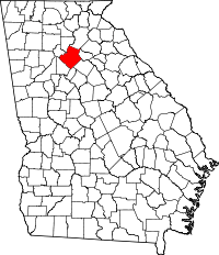 | |
| Towns | ||
| CDP | ||
| Unincorporated communities | ||
| Footnotes | ‡This populated place also has portions in an adjacent county or counties | |
|  | |||||||
|
| ||||||||
| ||||||||
Template:Georgia