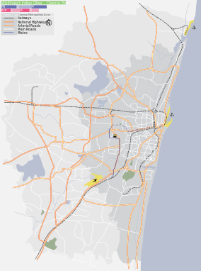
Indira Nagar, Chennai
For a locality in Lucknow, see Indira Nagar, Lucknow.
| Indira Nagar | |
|---|---|
| neighbourhood | |
 Indira Nagar  Indira Nagar  Indira Nagar | |
| Coordinates: 12°59′42″N 80°14′59″E / 12.995107°N 80.249590°ECoordinates: 12°59′42″N 80°14′59″E / 12.995107°N 80.249590°E | |
| Country | India |
| State | Tamil Nadu |
| District | Chennai District |
| Metro | Chennai |
| Government | |
| • Body | Chennai Corporation |
| Languages | |
| • Official | Tamil |
| Time zone | IST (UTC+5:30) |
| Planning agency | CMDA |
| Civic agency | Chennai Corporation |
| Website |
www |
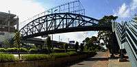
Rajiv Gandhi Salai in Indira Nagar
Indira Nagar (Tamil: இந்திரா நகர்) is a posh neighbourhood in Chennai, India.
Indira Nagar was developed by Tamil Nadu Housing Board (TNHB) in late 1970s and early 1980s.TNHB developed residential plots, apartments, commercial complexes, wide roads, school zones, bus terminus and large parks.
Indira Nagar is an excellent example of organized government town planning by Tamil Nadu Housing Board (TNHB),However it was a small scale development in comparison with other TNHB developments such as Anna Nagar, KK Nagar, Ashok Nagar and Besant Nagar. Indira Nagar MRTS station on the Chennai Mass Rapid Transit System serves the neighbourhood. Hindu Senior Secondary School is located in the area.
This article is issued from Wikipedia - version of the 8/7/2016. The text is available under the Creative Commons Attribution/Share Alike but additional terms may apply for the media files.