Chennai Metropolitan Area
| Chennai Metropolitan Area சென்னை மாநகர பரப்பு | |
|---|---|
| Metropolitan Area | |
 | |
| State | Tamil Nadu |
| Districts | |
| Area | |
| • Total | 1,189 km2 (459 sq mi) |
| Population | |
| • Total | 8,917,749 |
| • Density | 7,500/km2 (19,000/sq mi) |
| Demonym(s) | Chennaivasi, Chennaiite |
| Time zone | Indian Standard Time (UTC+5:30) |

The Chennai Metropolitan Area (Tamil:சென்னை மாநகர பரப்பு) is the fourth most populous, and the fourth largest metropolitan area in India and is the 22nd most populous city in Asia or the 40th most populous city in the world. The CMA consists of the metropolitan city of Chennai (Madras) and its suburbs. The Chennai Metropolitan Development Authority (CMDA) is the nodal agency that handles town planning and development within the metro area. Since 1974, an area encompassing 1189 km2 around the city has been designated as the Chennai Metropolitan Area (CMA) and the CMDA has been designated as the authority to plan the growth of the city and the area around it.
Economy
Chennai city economy of US$58.6 billion PPP[1] (US$17 billion nominal GDP, 2010)[2] is currently rated the fourth-largest economy in India, ahead of the Bangalore Metropolitan Area and after the Kolkata Metropolitan Area.[note 1]
Composition
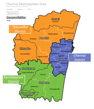
The CMA has an area of 1,189 km² spread over three districts. It includes the whole of the Chennai District, along with the Ambattur, Gummidipoondi, Madhavaram, Ponneri, Poonamallee and Tiruvallur taluks of the Tiruvallur District, and the Alandur Kanchipuram, Sholinganallur, Sriperumbudur and Tambaram taluks of the Kanchipuram District.
The City of Chennai (not to be confused with the Chennai District) currently covers an area of 426 km2 and now includes adjoining sections of Tiruvallur and Kanchipuram Districts along with the 176 km2 of the Chennai District. Prior to the expansion of the city's boundaries in September 2011, the city of Chennai (administered by the Chennai Corporation) fell completely within the Chennai District. There hasn't been any published update for the metropolitan population for the 2011 census, but the 3 districts in their entirety were home to over 12 million people in the 2011 census. Chennai City Limit Covers West side up to Poonamallee Taulk, Karanodai Near Redhills,Towards East Side ECR and OMR up to Kovalam Kelambakkam Region, North side Covers Manali Region and Minjur, towards South City Limit covers up to Vandalur Gate way of Chennai. Rest not covers within Real Chennai City Region.
The Chennai Metropolitan Area is set to be expanded further, incorporating the entire districts of Tiruvallur and Kancheepuram, and the Arakkonam taluk of the Vellore district.[3]
Nodal agencies
| Sn | Agency | Responsibility |
|---|---|---|
| 1 | Chennai Corporation (Madras Corporation), Municipalities and Panchayats | Civic management in their area of jurisdiction |
| 2 | Tamil Nadu Housing Board | provision of plots and ready built houses, Sites and Services schemes |
| 3 | Metropolitan Transport Corporation | Bus Transport |
| 4 | Southern Railway | Chennai suburban railway and Chennai MRTS |
| 5 | Chennai City Traffic Police | Traffic Management Schemes |
| 6 | Tamil Nadu Electricity Board | Electricity generation and supply |
| 7 | Public Works Department | Implementation & Maintenance of macro drainage system |
| 8 | Chennai Metropolitan Development Authority | Urban planning, co -ordination of project implementation |
| 9 | Chennai MetroWater Supply and Sewage Board | Water Supply & Sewerage facilities for CMA |
| 10 | Tamil Nadu Slum Clearance Board | Provision of housing, infrastructure and livelihood programs in slum areas |
| 11 | Aavin Co operative society | Providing Milk through co-operative society to the people of Chennai |
Profile
Chennai (Madras), the capital City of Tamil Nadu is the fourth largest Metropolitan City in India. The Chennai Metropolitan Area (CMA) comprises the city of Chennai, 16 Municipalities, 20 Town Panchayats and 214 Village Panchayats in 10 Panchayat Unions. The extent of CMA is 1189 km2.
The CMA falls in three Districts of the Tamil Nadu State viz. Chennai District, part of Thiruvallur District, and part of Kancheepuram District. The extent of the Chennai District (covered in Chennai Municipal Corporation area) is176 km2 and comprises 55 revenue villages in 10 Taluks [viz. (i) Tondiarpet Taluk, (ii) Perambur Taluk, (iii) Purasawalkam Taluk, (iv) Egmore Taluk, (v) Mambalam Taluk, (vi) Guindy Taluk, (vii) Mylapore Taluk, (viii) Velachery Taluk, (ix) Aminjikarai Taluk and (x) Ayanavaram Taluk. In Thiruvallur District out of total district area of 3427 km2, 637 km2. in Ambattur, Thiruvallur, Ponneri and Poonamallee taluks fall in CMA. In Kancheepuram District out of 4433 km2, 376 km2 in Tambaram, Sriperumbudur and Chengalpattu Taluks fall in the Metropolitan area.
CMA region has about 3,000 water bodies, most of which have been encroached upon by real estate dealers and small communities.[4]
Expansion
The CMDA regulates developments in the Chennai Metropolitan Area through the issuance of planning permission under section 49 of the Tamil Nadu Town and Country Planning Act 1971.[5][6]
The first plans to expand the CMA were proposed by the CMDA in 2011. The need for expansion arose as several nearby settlements such as Sriperumbudur, Kelambakkam, Tiruvallur and Maraimalai Nagar had been undergoing rapid development and had to be incorporated under the CMDA planning strategy. Also, the planning bodies of other metropolises in India such as Bengaluru, New Delhi and Hyderabad had already redefined their respective metropolitan regions to include much larger areas and corresponding regional planning was being done. The CMA, however, hasn't been altered since it was first defined in 1974. The area was limited to 1,189 km2 (459 sq mi) which is among the smallest in the country.[7]
In July 2012, the CMDA suggested two options to the Government of Tamil Nadu for expanding the area:
- The first option includes whole of the Chennai district, Gummidipoondi, Ponneri, Uthukottai, Ambattur, Thiruvallur and Poonamallee taluks of the Tiruvallur district, and Tambaram, Sriperumbudur and Chengalpattu taluks of the Kancheepuram district extending up to 4,459 km2 (1,722 sq mi).
- The second option includes the whole of Chennai, Tiruvallur and Kancheepuram districts and the Arakkonam taluk of Vellore district and extends to a total of 8,878 km2 (3,428 sq mi).
Chief planners of the CMDA have suggested that the second option is more feasible.[8] Another planning model, similar to the National Capital Region was also examined by the CMDA. In order to plan for balanced regional development, developing a larger road network, implementing an integrated transport plan and identifying a Chennai Mega Region have become necessary.[9]
-
 Area: 8,878 km2
Population: 12,906,602
Density: 1454/km2
Notes
- ↑ Rankings of cities by metropolitan area GDP can vary as a result of differences in the definition of the boundaries and population sizes of the areas compared and the method used to calculate output
References
- ↑ "Global city GDP 2013-2014". Brookings Institution. Archived from the original on 4 June 2013. Retrieved 8 May 2015.
- ↑ "The Most Dynamic Cities of 2025". Foreign Policy. Retrieved 24 August 2012.
- ↑ C Shivakumar (24 August 2015). "Chennai Expansion Could Be Tricky, Suggests History". The New Indian Express.
- ↑ Hemalatha, Karthikeyan (10 November 2012). "40 Chennai lakes to get a new lease of life". The Times of India. Chennai: The Times Group. Retrieved 10 Nov 2012.
- ↑ "The Tamil Nadu Town and Country Planning Act, 1971 (Tamil Nadu Act 35 of 1972)" (PDF). Government of Tamil Nadu. Retrieved 1 September 2015.
- ↑ Aloysius Xavier Lopez (10 November 2012). "Challenging times for building panel". The Hindu. Chennai.
- ↑ "Final call on Greater Chennai by fiscal year-end". IBN Live. 26 August 2011.
- ↑ C Shivakumar (2012-08-10). "Cities / Chennai : Push to expand Chennai Metropolitan Area". New Indian Express.
- ↑ A. Srivathsan (2011-10-28). "Cities / Chennai : Delhi planning model proposed for city". The Hindu. Retrieved 2012-11-09.