Chromepet
| Chromepet குரோம்பேட்டை | |
|---|---|
| neighbourhood | |
|
Chromepet Flyover on GST road | |
 Chromepet | |
| Coordinates: 12°57′06″N 80°08′27″E / 12.95161°N 80.14097°ECoordinates: 12°57′06″N 80°08′27″E / 12.95161°N 80.14097°E | |
| Country | India |
| State | Tamil Nadu |
| Metro | Chennai |
| Government | |
| • Body | CMDA |
| Languages | |
| • Official | Tamil |
| Time zone | IST (UTC+5:30) |
| PIN | 600044 |
| Vehicle registration | TN-11(Chromepet),TN-85(Thirumudivakkam) |
| Planning agency | CMDA |
| Civic agency | Chennai Corporation |
| Website |
www |

Chromepet is a Residential Locality in the southern part of Chennai, India. It is located 16 kilometres from Egmore. It lies on the Grand Southern Trunk (GST Road), close to Tambaram and next to Pallavaram. It is 4 km south of the Chennai International Airport, Tirusulam. It is the home of the famous Madras Institute of Technology, the institute where Dr. A. P. J. Abdul Kalam, former president of India and Tamil writer Sujatha studied. The neighbourhood is served by Chrompet railway station of the Chennai Suburban Railway Network.
Etymology
Chromepet is not a Tamil name. Earlier the town was the home of Chrome Leathers so the name chrome and pettai (Tamil: பேட்டை in Tamil means 'an Estate'). This company has been completely demolished and Balaji Hospital has been built in that Place. But, still you can find the traces of Chrome Leathers (its name board) when you walk through the CLC Works road, near the Chromepet Police Station .
History
The area was a part of Thondaimandalam ruled by Thondaimaans who were allied with the early Cholas from around the first to the second century AD. Later the area was passed on to the chieftains of the Satavahanas. Chennai, Chengulpet and surrounding area belonged to the Thondai Nadu during the Pallava period (3rd to 7th century AD). The historic period proper begins with the Pallava kings and the earliest of their stone inscriptions is found nearby in Pallavaram (Pallava puram) in a cave temple excavated by Mahendravarman I (AD 600–630).[1] Narasimhavarman I who succeeded Mahendravarman I waged battles against Pulekesin of the Chalukya dynasty and defeated him at Manimangalam which is 11 km (6.8 mi) south-west of Chromepet.
Chola period
During the later Chola period (9th to 12th century AD) the area, which is now called Chromepet, belonged to the Churathur Nadu, named after Thiruchuram, the modern Trisulam village near Pallavaram. The Churathur Nadu extended from Tambaram in the south to Adambakkam and Alathur (Alandur) in the north and included Pammal, Pallavaram and Tirunirmalai.[2]
Pandya, Telugu Chola, Vijayanagar
Later the lands passed on to Pandya, Telugu Chola and the Vijayanagar dynasties between the 12th and 15th centuries.
British rule
During the British rule in the 18th century, the leather industries developed in the southwest of the city. The Chrome Leather Company was established in this area in 1912 by European merchant Alexander Chambers. After his lifetime, the Chrome Leather Company was run by his wife Ida L. Chambers. She became the sole owner of the Chrome Leather Company and its properties in 1965 through an Order and Decree passed by the Honourable Court, Madras. She died in 1968.
Today the lands and properties of Chrome Leather Company belong to the late Ida L. Chambers, and most of the land to the west of the railway station is owned by CLC.
After independence, the Madras Institute of Technology (MIT) was founded in 1949 in an area extending over 20 hectares at Chromepet. Residential and commercial development started in the 1960 s. Kulasekarapuram is the name of the area before MIT was established.
Post-Independence
Development of New Colony and the auction of residential lots in the early 1950 s, by the Chrome Leather Company, led to rapid residential and commercial development of the Chromepet area.
Location in Context
 |
Thiruneermalai | Pallavaram | Pallavaram | |
| Periya Eri | |
Nanmangalam Lake | ||
| ||||
| | ||||
| Tambaram | Chitlapakkam / Chitlapakkam Lake | Hastinapuram Eri / Nanmangalam Reserved Forest |
Neighbourhoods
Chromepet is made up of communities and townships:
- New Colony is on the west side of the railway station. It is primarily a residential area surrounded by schools and colleges.
- Ganapathy Puram is on the east side of the railway station which has three famous temples in its locality. Chengacheri amman temple, Nagathamman temple (dedicated to Protector of Snake's home), and Abishta Varada Maha Ganapathy temple. This is one area where most of the street names derived from the oldest person lived over there.
- Umayalpuram is a residential area in Chomepet.
- Nagappa Nagar is a development which lies beyond New Colony to the west. Once empty land owned by the Chrome Leather Company, it was sold to builders and the entire land has been developed.
- Lakshmipuram is an old town lying beyond Nagaappa Nagar.
- Shastri Colony is an old town behind Vettri Theatre.
- Gandhi Nagar is located adjacent to Station Road. Metropolitan bus depot is located in Gandhi nagar. Gandhi Nagar comprises streets like Valluvar Main Road, Valluvar 1st 2nd and 3rd street, Va Voo See Street, Vivekanandar street, Kamaraj Street, Bharathiyar Street, etc. Sri Durgai Amman Temple is a temple located in Gandhi Nagar adjacent to Radha Nagar.
- Ranga Nagar is on the west side of Lakshmipuram, near a lake. A Pillayar Kovil is located near the lake. Adjacent to this are Saraswathipuram and Parvathipuram.
- Subbaraya Nagar is on the Tiruneermalai road on the other side of the lake (Periyar Eri). Eri means lake in English
. Pillaiyar temple is known as Vembarasu Pillaiyar temple or popularly known as "Eri Karai" Pillaiyar temple. On the other side of the Pillaiyar temple is Subbaraya Nagar.
- Radha Nagar is on the east side of the train station. It is the trading hub of Chromepet. It houses banks, shops and trading establishments. Chromepet Public Health Center was donated to the residents of Chromepet during the 1950 s by Prof T. S. Partha and is presently rented to AG Hospital. It is run by trustees headed by Mr. T. Madanagopal who is the President is a hospital situated in Bharathi Street, which is an important road junction. Sri Ram Clinical Lab is one of the famous clinical lab in Radha Nagar. Radha Nagar railway gate is a famous railway gate in Chromepet
- Sri Rama Anjenaya Temple is a temple located in Radha Nagar.
- Shanthi Nagar is on the east side of the railway station. It is a residential hub of Chromepet. It houses small vendors, shops and trading establishments. The Ladies College [Vaishnav College] is in Shanthi Nagar.
- Nehru Nagar is one of the oldest and popular residential areas in Chromepet. It lies south-east of the Chromepet Railway station. The whole of Nehru nagar was once fields where chillies were grown. Nehru Nagar has the Madras Institute of Technology (M. I. T). The M. I. T staff residential quarters and access grounds used to be called Rani Thottam (Queens garden) which has historical significance. Nehru Nagar now has flats and a large residential area. The land prices are at a premium here due to the newly constructed over-bridge across the M. I. T railway gate. The M. I. T flyover provides easy access to Chitlapakkam and Hasthinapuram from G. S. T Road
- There are three important Hindu shrines in Nehru Nagar. One is Kumaran Kundram which is dedicated to Lord Muruga. Lord Muruga resides on a small hillock and this deity is considered to be as powerful as the deity in Kumbakonam, Swamimalai, one among the six houses of Lord Muruga. Second is the temple for Lord Vinayaga called the Varasidhi Vinayagar temple. The Shiva Lingam Aavudayar faces south which is very rare and the Lingam is a Suyambu brought from Kashi. Third is the temple for Lord Dhanushkodi Kothanda Ramar which was built in 2003 in Padmanabhan Street. Lord Ram in this temple is Sadhurbuja Raman with Sadhur bujam.
- Krishna Nagar, is the desirable residential area in Chromepet. Most houses were bungalows but have now been replaced with flats. Sri Rama baktha samajam was started in the 1960 s by the colony people. Shyam's Badminton Academy is running regular coaching classes. In addition the only available volleyball play ground is on for more than 30 years.
- Gajalakshmi Nagar is a neighborhood located on the eastern side of the train station. It is a residential locality, nestled between State Bank Colony and Kumaran Kundram, the hill shrine of Lord Muruga. Tirupur Kumaran children's park is at 3rd Cross Street, which has walkers pathways and children's play equipment.
- Nagalkeni is where the leather industry once thrived. The Tamil Nadu government school, the oldest Adi-Dravida Higher Secondary School, is located in Nagalkeni. The groundwater was polluted by industry. The area continues to be an industrial center; one noted company is the Tag Corporation, which manufactures heavy electrical equipment. With the construction of a railway overbridge on the Pallavaram-Thoraipakkam radial road, this area will become much more accessible to the IT corridor than East Tambaram and is hence attracting real estate investment.
- Kamaraj Nagar behind to Nagalkeni school. It is a calm and well developed area. For this place we can reach either Chromepet and Pallavaram within 5 minutes. Our area councler is Mr. Sudhakar
- Arkeeswarar Colony is adjacent to Nagelkeni. This colony is the property of Arkeeswarar Kovil and has 7 streets in it.
- Bharathipuram is on the east side of the train station. It is surrounded by Radha Nagar, Nemillichery, Purushotham Nagar. It is an old residential area.
- Purushotham Nagar is located on the east side of the train station. It is surrounded by Hastinapuram, State Bank Colony, Bharatipuram. This is one of the fastest growing residential areaa as it has school, bus, train and hospital facilities in close proximity.
- MRSG Nagar comprises Muthusamy Nagar, RK Nagar, Somu Nagar and Ganesh Nagar, located after AGS Colony in the far eastern end of Chromepet, connecting Nanmangalam in the east and Hasthinapuram and Thirumalai Nagar in the South. This area falls under Nemilicherry. The Don Bosco School and Church, the Sai Educational Institute and Zion school are very near to this area making this a good residential area. The MRSG Residential Welfare Association itself is known for its welfare and community works.
- BBR (Bashyam, Bhuvaneswari, Raghava Nagar and Pachaippa) Nagar is one of the residential localities, located between Purushotham Nagar and Hasthinapuram. Though most of the residences are independent houses, recently quite a lot of apartments have been constructed in this locality including one by AGNI Foundation. The locality also houses the famous Nilgris' shopping mart. This place is adjacent to 'Kumaran Kundram' the famous Lord Muruga abode. The BBR nagar association has taken quite a lot of proactive steps over the years to improve the locality. The association is housed in an enclosure that consists of the association building and a small hall which is rented out to the residents and non-residents for small get-togethers and functions like ear piercing, birthday celebrations etc. In addition, a small park with a walking area is also maintained by the association. Recently an indoor stadium with one badminton and one table tennis court was constructed by the association with help from residents, philanthropists with due permission from the local municipality. The Indoor stadium also houses a small gymanisium that is open to public for a reasonable monthly charge. The association also helps poor children studying in nearby schools by donating note books and uniforms every year.Recently this association is open a new building with well furnished office and in this building having yoga, carrom and chess coaching to all public.
- Hastinapuram is on the south-eastern end and one of the fastest growing residential areas. This has the Hasthinapuram Bus Terminus. Buses to many places in Chennai are available from this terminus.
- Padmanaba Nagar is one of the residential localities, located in fag end of the chrompet pincode in the eastern side.Though most of the residences are independent houses, recently quite a lot of apartments have been constructed in this locality. A temple "Sri Karumariamman Temple" is famous temple.
- Chambers Colony (CLC Line) is an very old residential locality in Chromepet.most of the people there worked in the Chrome leather Company.
- Cholavarm Nagar" is an old residential locality in Chromepet. It is behind Vetri Theatre and very near to rail, road and hospitals. The once polluted ground water of this area due to tannery waste has changed and now it is pure.
- Reserve Bank Colony is in Chromepet, behind the Vettri Theater, half a kilometer from the GST Main Road. This is one of the best residential colonies in Chromepet. The enclave is around 8 acres (32,000 m2) of land with around 100 houses/bungalows surrounded by coconut trees and orchid plants. This is most safest residential colony in last 40 years not even one crime reported.
- Central Bank Colony is located next to the Reserve Bank Colony. Nearly one kilometer from GST Road behind the Vetri Theatre. To the south is Nagappa Nagar. It has shortcuts connecting to Thiruneermalai and Pammal areas. It is one of the fastest developing residential parts of the Chromepet.
- Krishnama Chari Street is located at the back of Sri Rama Anjenaya Temple. Vasantha Mandapam is a small community hall which is maintained by the Sri Rama Anjenaya Temple.
- Ganapathypuram adjoining Radhanagar, is an important residential locality. The area has a newly renovated Ganapathy Temple and the "Chengacheri Amman" and " Nagathamman " Kovils which draws large number of devotees. Ganapathypuram also houses several residential apartments, the latest being the "Orchid Chengachery" Apartments in Munusamy Street.
- Jamin Royapettai is one of the oldest area in eastern Chromepet. Padavettamman Temple which is located here is around 300 years old and every year in August (1st week or 2nd week) a grand festival is celebrated. It is celebrated on fourth Sunday in the Tamil month of Aadi. Main part of the celebration is Theemithi Thiruvizha when devotees, who observed day-long fasting, walk on fire spread in front of the temple to reach the sanctum sanctorum.
- Nemilicherry is next to Jamin Royapettai & well connected with transport like government bus. Here Sri Sathya Sai Institute of Educare, a residential CBSE school is situated. Here they teach value-based education and students from all over India studying here. AGASTHIYAR TEMPLE in Nemilichery is more than 1500 years old.
- kurinjinagar is the way of entering to 200 feet road connects to Thoraipaakam rd and ECR road (ECR 13 km from Kurinji Nagar). It is extension of Shakthi Nagar, Varathan Nagar, Aishwarya Nagar & Surya Avenue and these are near Vels Engg. college and Padaveetamman koil.
Neighbourhood newspapers
Transportation links
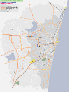
Chromepet is connected to the city of Chennai by public transportation services including the electric train service that was built during British rule. Chromepet is located on the Beach – Tambaram – Chengalpattu suburban railway network. See Chennai suburban railway
Chromepet is 3 km away from Chennai Airport. The Pallavaram – Perungudi bypass road connects Chromepet with Adambakkam, Nanganallur, Madipakkam, Medavakkam, Velacheri and Perungudi. Chitlapakkam main road connects Chromepet with Selaiyur and East Tambaram.
The Grand Southern Trunk Road (GST) that connects south Indian cities to Chennai passes through this township.
The MIT Flyover connects Grand Southern Trunk Road (GST) with Hasthinapuram and Chitlapakkam. The Flyover (near Ponds company) connects Tiruneermalai on the west and Thoraipakkam 100 feet outer ring road with the GST.
There is a bus stand in Hasthinapuram, a neighborhood on the eastern side of Chromepet Railway Station. Buses to Tambaram, Guduvanchery, T Nagar, High Court, Chengalpet, Avadi, Pallavaram, Velachery, vandalur, Pozhichalur, Broadway, etc. are available from Hasthinapuram.
Marriage halls
- Selvam Mahal A/c
- Shakthi Thirumana Maaligai
- Arasan Mahal
- Ananda Thirumana Maaligai
- Sree Balaji Mahal
- Kandhasamy thirumana Mandapam
- Radha Kalyana Mandapam
Buses
Main bus services from Hastinapuram are:
- 52 B – Hastinapuram to Highcourt via Saidapet, LIC – every 1 h.
- M52 B – Hastinapuram to Pozhichalur via Chromepet, Pallavaram – every 15 min.
- 152 B – Hastinapuram to Highcourt via Kotturpuram, Mylapore – every 1 h.
- H70 – Hastinapuram to pattabiram via CMBT, Avadi – every 2 h.
- M18G – Hastinapuram to Guduvancheri via Tambaram – every 2 h.
- 500 A – Hastinapuram to Chengalpet via Tambaram – every 2 h.
- 52 T – Thirumalai Nagar to Pallavaram via Hastinapuram – every 2 h.
- 52E – Nemilicheri To Highcourt via Saidapet.
- 52 C – Hastinapuram to T. Nagar via Saidapet – every 1 h.
- 66 A – Hastinapuram to Kundrathur
- 52 S — Nemilicheri To Pozhichalur via Nehru nagar
- 66 A — Hastinapuram To Poovirunthavali via Nehru nagar
There is also a route from Tambaram West to Velachery via Hastinapuram. (21B)
Institutions in and around Chromepet
Institutions
- Mass Overseas Education Consultants
Schools
- Holy Queen Matriculation School
- Hilton Matriculation School
- Government Board High School
- Sri Sankara Vidyalya Matric.hsc school pammal 75
- Nappinnai Matriculation School
- N. S. N Matriculation Higher Secondary School
- St. Mark's Matriculation Higher Secondary School
- Olive Public International School
- Smt.Ramkuwar Devi Fomra Vivekananda Vidyalaya
- Smt.Sundravalli Memorial School
- Fatima Convent
- Viignesh Vinayagar school, Bharathipuram
- Sri Sathya Sai Institute of Educare, Chromepet
- Modern Matriculation School, Cholvaram Nagar
- Saviour Jesus Matriculation Higher Secondary School
- Holy Angels Matriculation Higher Secondary School
- Neelaram Matriculation Higher Secondary School
- Sri Seshadri Matriculation School
- S.C.S Matriculation Higher Secondary School
- Prakash Institute, Opp. MIT
- Sampath institute
- Ayyasami school, Nehru nagar
- Violet scchool
- GGN Matriculation School
- Smt.Lakshmi Ammal Memorial School
- Shiksha Matriculation higher Secondary School
- Hello Kids Bunnies — Preschool/ Play School / Kindergarten / Nursery / Day Care, Reserve Bank Colony, Chambers Colony Main Road, Chromepet, Chennai - 600044
- Jordans International Preschool
- Narayana e-techno School
- Government Boys Higher Secondary School
Colleges
- Madras Institute of Technology
- S.D.N.B Vaishnav College for Women
- Sree Balaji Medical College and Hospital
- Eva Stalin Business School
- Tagore Arts and Science College
- I.R.T Polytechnic College
- Anna University K B Chandrashekar Research Center
- Anna University of Technology Coimbatore Directorates of Online & Distance Education
- Annamalai University Study Center
Hospitals
- Government General Hospital
- Sree Balaji Medical College and Hospital
- Deepam Health Care
- Chennai Krishna Hospital
- Parvathy Hospital
- Chromepet Government Hospital
- Royal Balaaji Hospitals
- Subhiksha hospital
- R.K.Nursing Home- Multi-speciality Centre.
- Rasi hospital
- Deepam Hospital
SGS Nursing Home
Temples
- 300 years old Arulmigu Angalaparameswari Amman temple, Nagalkeni, near TAG Corporation.
- Sri Sanjeevi Varatha Anjaneyar Temple - 10th Street, Thirumalai Nagar
- Immaculate conception (near Holy Angels school)
- Thiruneermalai Perumal Temple 5 km away,a divya desam
- Arulmigu Suyambu Durgai Amman Temple [Lakshmipuram]
- Maathamman Maheswari Temple [Chambers Colony] 110 years old
- Padavettamman Koil, (Zameen Royapettai)
- Kumaran Kundram Murugan Temple, Nehru Nagar
- Sri Varasidhi Vinayagar Aaalayam, Nehru Nagar
- Hanuman Temple near MIT College
- Sri Muthu Mari Amman Temple (in Laksmipuram)
- Sri Sundara Vinayagar Temple – New colony
- Sri Agatheeswarar temple, Nemilicherry
- Sri Chengachjery Amman Temple – Radha Nagar
- Arulmigu Sri Durgai Amman Temple;- Station Road
- Ponni Amman Koil (Vembuli Amman Kovil)- Thirumalai Nagar
- Sri Sathya Sai Baba Temple – Venkatraman Nagar
- Vijaya Vinayakar Temple, 3rd Cross St, Purushotham Nagar
- Sri Rama Anjaneya Temple, Radha Nagar
- Rama Anchenayar Koil, Maruthi Nagar, Hastinapuram
- Chittarai amman temple and Garden near Chrome Leather Tannery
- Vembarasu Vinayakar Temple near Periya Eri
- Kodanda Rama Temple — Nehru Nagar
- Gangai amman temple, Nemilicherry
- Sri Lakshminarayana perumal Temple, Nehru Nagar
- Sri Abista Varadha Mahaganapathy Temple, Ganapathipuram
- Shri Varasidhi Vinayagar Temple, Cholavaram Nagar
- Shri Rama Anjaneyar Temple — Hasthinapuram, Maruthi Nagar
- Shri Vilvanathar Temple
- Sakthi Ganapathi Temple — Lakshmi Nagar, Near Vaishnava College
Theatres
- Vetri
- Rakesh
- Varadharaja
- LAKSHMI
Thalaiva IMAX
Government Offices
- Pallavaram Municipality
- Commercial Sales Tax Office
- Post Office
- Sub Registrar Office
- Police Station
- BSNL Telephone Exchange
- Fire Station
- Siddha Institute
- TNEB
Notes
References
| Wikimedia Commons has media related to Chromepet. |