Frederick County, Virginia
| Frederick County, Virginia | ||
|---|---|---|
|
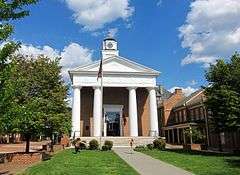
The Old Frederick County Courthouse in Winchester | ||
| ||
 Location in the U.S. state of Virginia | ||
 Virginia's location in the U.S. | ||
| Founded | 1743 | |
| Named for | Frederick, Prince of Wales | |
| Seat | Winchester | |
| Largest town | Stephens City | |
| Area | ||
| • Total | 416 sq mi (1,077 km2) | |
| • Land | 414 sq mi (1,072 km2) | |
| • Water | 2 sq mi (5 km2), 0.5% | |
| Population (est.) | ||
| • (2015) | 83,199 | |
| • Density | 200/sq mi (77/km²) | |
| Congressional district | 10th | |
| Time zone | Eastern: UTC-5/-4 | |
| Website |
www | |

Frederick County is a county located in the Commonwealth of Virginia. As of the 2010 census, the population was 78,305.[1] Its county seat is Winchester.[2] The county was formed in 1743 by the splitting of Orange County. It is Virginia's northernmost county.
Frederick County is included in the Winchester, VA-WV Metropolitan Statistical Area, which is also included in the Washington-Baltimore-Northern Virginia, DC-MD-VA-WV-PA Combined Statistical Area.
History
The area that would become Frederick County, Virginia was inhabited and transited by various indigenous peoples for thousands of years before European colonization. The "Indian Road" refers to a historic pathway made by local tribes.
Frederick County was established in 1743 from parts of Orange County. (At that time, "Old Frederick County" encompassed all or part of four counties in present-day Virginia — Shenandoah, Clarke, Warren, and Frederick — and five in present-day West Virginia — Hardy, Hampshire, Berkeley, Jefferson and Morgan.) The Virginia Assembly named the new county for Frederick Louis, Prince of Wales[3] (1707–1751), the eldest son of King George II of Great Britain.
Colonial Era
As Commander-in-Chief of the new Colonial Virginia regiment in 1754, Colonel George Washington's headquarters were located in Winchester before and during the French and Indian War. He resigned from military service in 1758; only to be appointed General by the Continental Congress sixteen years later. Meanwhile, Washington represented Frederick County in his first elective office, having been elected to the House of Burgesses in 1758 and 1761. Daniel Morgan was another famous General during the American Revolutionary War, from (present day Clarke County).
American Civil War
Winchester changed hands between the Confederate and Union Armies on average once every three weeks during the war. Many battles were fought in Frederick County. Some of those battles include:
- First Battle of Kernstown, March 1862
- First Battle of Winchester, May 1862
- Second Battle of Winchester, June 1863
- Second Battle of Kernstown, July 1864
- Third Battle of Winchester (Battle of Opequon), September 1864
- Battle of Cedar Creek, October 1864
The first constitution of West Virginia provided for Frederick County to be added to the new state if approved by a local election.[4] Unlike those of neighboring Berkeley and Jefferson counties, Frederick County residents voted to remain in Virginia despite being occupied by the Union Army at the time.
Geography
According to the U.S. Census Bureau, the county has a total area of 416 square miles (1,080 km2), of which 414 square miles (1,070 km2) is land and 2 square miles (5.2 km2) (0.5%) is water.[5] This is the northernmost county in the Commonwealth of Virginia.
Adjacent counties
|
|
National protected areas
- Cedar Creek and Belle Grove National Historical Park (part)
- George Washington National Forest (part)
Demographics
| Historical population | |||
|---|---|---|---|
| Census | Pop. | %± | |
| 1790 | 19,681 | — | |
| 1800 | 24,744 | 25.7% | |
| 1810 | 22,574 | −8.8% | |
| 1820 | 24,706 | 9.4% | |
| 1830 | 26,046 | 5.4% | |
| 1840 | 14,242 | −45.3% | |
| 1850 | 15,975 | 12.2% | |
| 1860 | 16,546 | 3.6% | |
| 1870 | 16,596 | 0.3% | |
| 1880 | 17,553 | 5.8% | |
| 1890 | 17,880 | 1.9% | |
| 1900 | 13,239 | −26.0% | |
| 1910 | 12,787 | −3.4% | |
| 1920 | 12,461 | −2.5% | |
| 1930 | 13,167 | 5.7% | |
| 1940 | 14,008 | 6.4% | |
| 1950 | 17,537 | 25.2% | |
| 1960 | 21,941 | 25.1% | |
| 1970 | 28,893 | 31.7% | |
| 1980 | 34,150 | 18.2% | |
| 1990 | 45,723 | 33.9% | |
| 2000 | 59,209 | 29.5% | |
| 2010 | 78,305 | 32.3% | |
| Est. 2015 | 83,199 | [6] | 6.2% |
| U.S. Decennial Census[7] 1790-1960[8] 1900-1990[9] 1990-2000[10] 2010-2012[1] The drop from 1830 to 1840 was because Clarke and Warren counties were split off. | |||
As of the census[11] of 2000, there were 59,209 people, 22,097 households, and 16,727 families residing in the county. The population density was 143 people per square mile (55/km²). There were 23,319 housing units at an average density of 56/square mile (22/km²). The racial makeup of the county was 94.99% White, 2.62% Black or African American, 0.16% Native American, 0.66% Asian, 0.02% Pacific Islander, 0.56% from other races, and 1.01% from two or more races. 1.70% of the population were Hispanic or Latino of any race.
There were 22,097 households out of which 36.60% had children under the age of 18 living with them, 62.50% were married couples living together, 8.80% had a female householder with no husband present, and 24.30% were non-families. 19.20% of all households were made up of individuals and 6.80% had someone living alone who was 65 years of age or older. The average household size was 2.64 and the average family size was 3.02.
In the county, the population was spread out with 26.40% under the age of 18, 7.00% from 18 to 24, 31.90% from 25 to 44, 24.10% from 45 to 64, and 10.60% who were 65 years of age or older. The median age was 37 years. For every 100 females there were 100.10 males. For every 100 females age 18 and over, there were 96.70 males.
The median income for a household in the county was $46,941, and the median income for a family was $52,281. Males had a median income of $35,705 versus $25,046 for females. The per capita income for the county was $21,080. About 4.00% of families and 6.40% of the population were below the poverty line, including 7.30% of those under age 18 and 6.90% of those age 65 or over.
Government
Board of Supervisors
Chairman: Richard C. Shickle (R)
Back Creek District: Gary A. Lofton (R)
Gainesboro District: Robert Hess (R)
Opequon District: Robert Wells (R)
Red Bud District: Blaine P. Dunn (R)
Shawnee District: Gene E. Fisher (R)
Stonewall District: Charles S. DeHaven, Jr. (R)
Constitutional Officers
Clerk of the Circuit Court: Rebecca P. "Becky" Hogan (D)
Commissioner of the Revenue: Ellen E. Murphy (R)
Commonwealth's Attorney: Ross Spicer (R)
Sheriff: R.T. "Bob" Williamson (R)
Treasurer: C. William Orndoff, Jr. (R)
Frederick is represented by Republican Jill Holtzman Vogel in the Virginia Senate, Republicans J. Randy Minchew, Mark Berg, and Joe T. May in the Virginia House of Delegates, and Republican Barbara Comstock in the U.S. House of Representatives.
Transportation
- Winchester Transit provides weekday transit for the city of Winchester.
Major Highways
Education
Frederick County is served by Frederick County Public Schools, which includes several elementary, middle, and high schools. Frederick County is also part of the region served by the Mountain Vista Governor's School that offers upper level classes to intellectually gifted high school students.
Schools
Elementary Schools
|
|
|
Middle Schools
- Admiral Richard E. Byrd Middle School
- Frederick County Middle School
- James Wood Middle School
- Robert E. Aylor Middle School
High Schools
Colleges
Universities
Libraries
Communities

Despite being the county seat, Winchester, like all cities under Virginia law, is an independent city—politically independent of any county.
Towns
Unincorporated communities
- Albin
- Armel
- Bartonsville
- Brucetown
- Burnt Factory
- Canterburg
- Cedar Grove
- Cedar Hill
- Clear Brook
- Cross Junction
- De Haven
- Gainesboro
- Good
- Gore
- Gravel Springs
- Greenwood
- Green Spring
- Grimes
- Hayfield
- Indian Hollow
- Jordan Springs
- Kernstown
- Klines Mill
- Lake Frederick
- Leetown
- Lehew
- Marlboro
- McQuire
- Meadow Mills
- Mill Race Estates
- Mount Pleasant
- Mount Williams
- Mountain Falls
- Mountain Falls Park
- Nain
- Opequon
- Parkins Mills
- Rest
- Reynolds Store
- Ridings Mill
- Rock Enon Springs
- Round Hill
- Shawnee Land
- Shockeysville
- Siler
- Star Tannery
- Stephenson
- Vaucluse
- Welltown
- Whitacre
- White Hall
- Wilde Acres
See also
- National Register of Historic Places listings in Frederick County, Virginia
- List of routes in Frederick County, Virginia
References
- 1 2 "State & County QuickFacts". United States Census Bureau. Retrieved January 2, 2014.
- ↑ "Find a County". National Association of Counties. Retrieved 2011-06-07.
- ↑ Gannett, Henry (1905). The Origin of Certain Place Names in the United States. Govt. Print. Off. p. 131.
- ↑ http://www.wvculture.org/HISTORY/statehood/constitution.html, Article I, Section 2
- ↑ "US Gazetteer files: 2010, 2000, and 1990". United States Census Bureau. 2011-02-12. Retrieved 2011-04-23.
- ↑ "County Totals Dataset: Population, Population Change and Estimated Components of Population Change: April 1, 2010 to July 1, 2015". Retrieved July 2, 2016.
- ↑ "U.S. Decennial Census". United States Census Bureau. Retrieved January 2, 2014.
- ↑ "Historical Census Browser". University of Virginia Library. Retrieved January 2, 2014.
- ↑ "Population of Counties by Decennial Census: 1900 to 1990". United States Census Bureau. Retrieved January 2, 2014.
- ↑ "Census 2000 PHC-T-4. Ranking Tables for Counties: 1990 and 2000" (PDF). United States Census Bureau. Retrieved January 2, 2014.
- ↑ "American FactFinder". United States Census Bureau. Retrieved 2011-05-14.
External links
- Official Website for the County of Frederick
- Frederick County Public Schools
- Winchester-Frederick County Chamber of Commerce
- Winchester Frederick County Convention and Visitor Bureau
- Winchester Frederick County Circuit Court Clerks
 |
Morgan County, West Virginia | Berkeley County, West Virginia | | |
| Hampshire County, West Virginia | |
Clarke County | ||
| ||||
| | ||||
| Hardy County, West Virginia and Shenandoah County | Warren County |
| Battles |  | |
|---|---|---|
| Raids and expeditions | ||
| Units | ||
| People | ||
| Places and tourism | ||
Coordinates: 39°13′N 78°16′W / 39.21°N 78.26°W